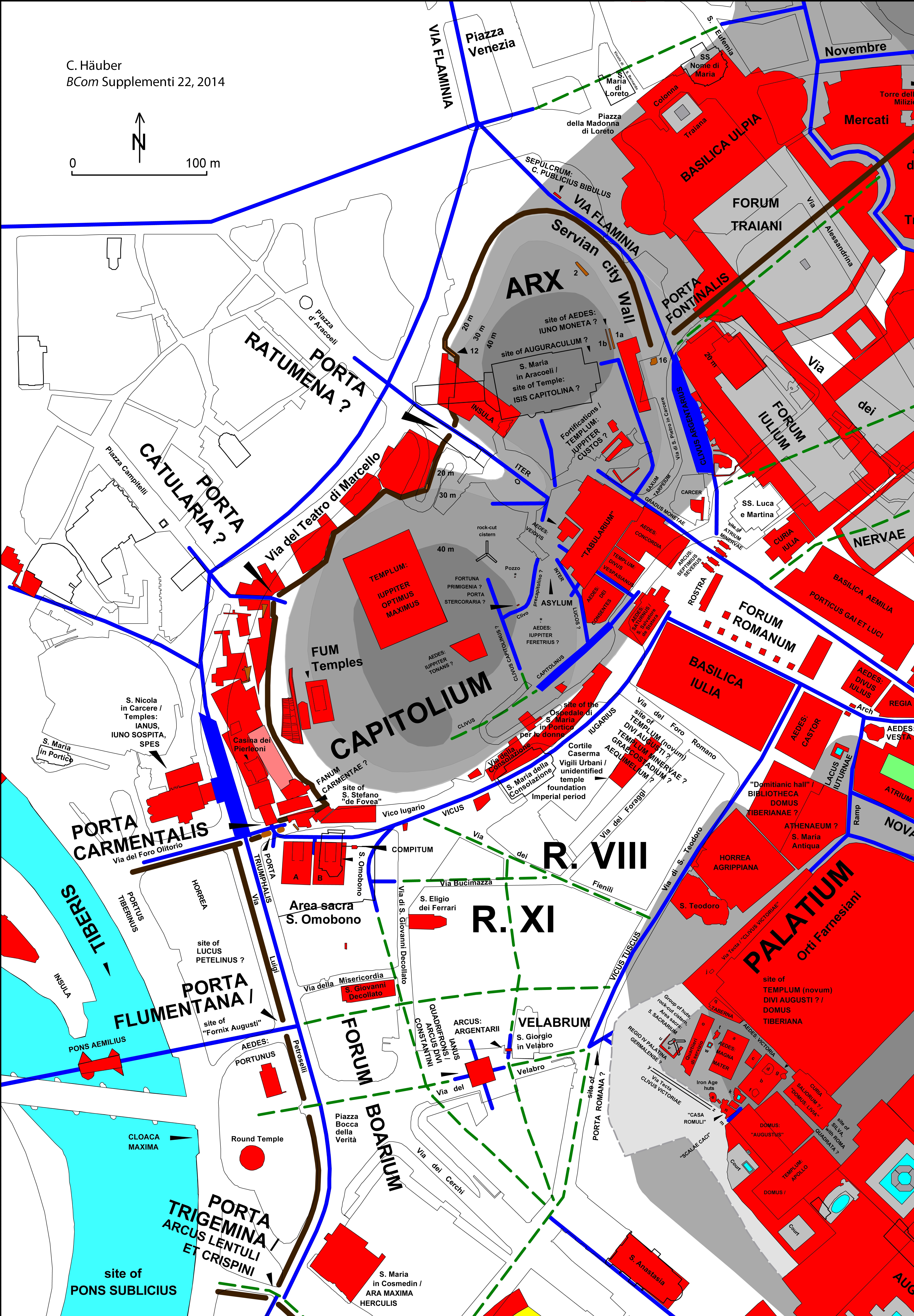
Diese Karte des Kapitols und des Palatins wurde als Map 5 veröffentlicht in:
Chrystina HÃĪuber, The Eastern Part of the Mons Oppius in Rome: the Sanctuary of Isis et Serapis in Regio III, the Temples of Minerva Medica, Fortuna Virgo and Dea Syria, and the Horti of Maecenas. With Contributions by Edoardo Gautier di Confiengo and Daniela Velestina, 22. Suppl. BullCom, Roma: <<L'ERMA>> di Bretschneider 2014.
Die folgenden (veränderten) Textpassagen stammen aus diesem Buch.
Häuber (2014, 874-875, Kapitel: "EXPLANATIONS FOR OUR MAPS"):
"Map 5: The Capitoline Hill and the valley between the Capitoline and the Palatine. Only topographical features, which can be certainly located are integrated into this map. Red areas indicate the ground-plans of ancient buildings. The sizes and shapes of the red areas do not represent in all cases the original sizes and shapes of the ground-plans of the ancient structures and buildings in question, because many of these were already heavily destroyed when found or documented, or had occurred in building sites, where it was impossible to document them in their entirety. Light grey areas within these read [corr.; red] areas are open air spaces, dark areas within those open air spaces are bases of monuments. Raised areas by which plateaus of hills were enlarged are indicated as light grey areas, bordered by dotted lines. Ancient roads are drawn as 3 m wide dark blue lines, and reconstructed ancient roads as dotted green lines. The Tiber, cisterns and water basins are drawn as blue areas, and gardens as green areas. The shaded relief was drawn after G.B. Nolli's Rome map (1748); following recent studies, the relevant cartographic information was at some points corrected.
This map was made with the ``AIS ROMAÂīÂī and is based on the photogrammetric data of the Comune di Roma (now: Roma Capitale). C. Häuber & F.X. Schütz, actual state September 13th, 2013, reconstruction. The photogrammetric data were generously provided by the Sovraintendenza ai Beni Culturali (BB.CC.) of the Comune di Roma (now: Roma Capitale). These data were generated for the ``Centro di Documentazione Forma RomaeÂīÂī, and are the basis of the project ``Nuova Forma Urbis RomaeÂīÂī; cf. chapter Acknowledgements and Introduction, of which C. Häuber and F.X. Schütz are cooperation partners".
Häuber (2014, 26, Kapitel: "2. The potential of maps â applied to the ones published here"):
"Already in the archaic period the Romans built substructures for their buildings which they themselves later admired and that are in some cases partly extant. T.P. Wiseman regards them ``as one of the marvels of old Roman engineeringÂīÂī, referring to the substructures of the temple of Iuppiter Optimus Maximus on the Capitolium [with n. 180]. Nolli based his map [1748] on his own drawing of the natural landscape, but did not always realize when the plateaus of the hills he drew had actually been enlarged in antiquity, and in those cases where those substructures were visible (as on the Palatine), he did not offer reconstructions of them. Because we have integrated into our maps the known ground-plans of ancient buildings and at the same time Nolli's orography, many of our ancient buildings appear now as if partly or completely `floating in the airÂī (map 3).
Ammerman and Terrenato have created a contour map of the natural relief of the Capitoline hill which resulted in the important ``realization that the Temple of Jupiter was not located in the center of the southern summit but on the W[est] side of the hillÂīÂī, as Ammerman reports [with n. 181]. We integrated their reconstruction into our maps and it is the best example for the just described effect on our maps (map 5, labels: CAPITOLIUM; TEMPLUM: IUPPITER OPTIMUS MAXIMUS [with n. 182]). In this case I have decided not to offer a reconstruction of the relevant substructure, because too little of it is left [with n. 183]".
Note 180: "Wiseman 1998a, p. 13 with n. 4 (with bibliography)".
Note 181: "Ammerman 2006, p. 299 with n. 9, pp. 300, 304".
Note 182: "I do not follow any of the recent reconstructions of the ground-plan of the temple of Iuppiter Optimus Maximus on my maps, because of the ongoing debate; cf. Häuber 2005; Ridley 2005; Tucci 2006a; Cifani 2008, pp. 80-109, 287-298. Francesco Paolo Arata told me on September 23rd 2011 in Rome that he identifies the large foundation, drawn on my map, with the area Capitolina instead; cf. Id. 2010b, p. 592 with n. 76, pp. 594, 621 with ns. 253-257".
Note 183: "Cf. Häuber 2005, p. 22".
Häuber (2014, 302-303, Kapitel: "APPENDIX II AN UNPUBLISHED REPORT BY ANGELO PELLEGRINI, THE PUTICULI AND THE VINA MAECENATIANA"):
"During the `excavationsÂī at the turn of the 19th and 20th centuries, many natural springs and cuniculi systems, including cisterns, were found on the Esquiline (as elsewhere in Rome): ``Talora sono stati tagliati anche cunicoli, appartenenti a opere di drenaggio e di presa antiche, dove ancora alla fine del secolo scorso scorreva acquaÂīÂī; unfortunately it is in most cases impossible to locate these hydraulic installations precisely, as reported by Renato Funiciello [with n. 121]. Jacqueline Calzini Gysens has recently re-studied the complex hydraulic installations near and at the sanctuary of the `SyrianÂī gods on the Janiculum, which are especially interesting for the context discussed here.
There the excavator Paul Gauckler had described ``un pozzo antico circolare âĶ [more than 7 m deep], sul fondo del quale si immettevano quattro brevi gallerie a croce per il captaggio di una sorgenteÂīÂī, which has been identified with the natural spring within the lucus Furrinae [with n. 122] (cf. separate box in map 3, labels: TRANSTIBERIM; LUCUS FURRINAE). John Ward-Perkins described similar cisterns on the plateau of the Etruscan town of Veii (at his supposed temple at the Piazza dâArmi [with 123]; cf. B 11.), of ``the self-replenishing type familiar also from early Rome, i.e. vertical shafts with several short lateral gal- [page 303] leries opening off radially to tap water-bearing strataÂīÂī [with n. 124]. He convincingly compared these cisterns at Veii with the cistern found underneath the Palazzo dei Conservatori, which according to Colini predated the construction of the Aqua Marcia (140/139 BC); this cistern has also been identified with the favissae Capitolinae [with n. 125] (map 5, labels: CAPITOLIUM; rock-cut cistern1 [with n. 26]).
Here again Troll's [with n. 127] identification of quanat and cuniculi systems seems to prove right, since Andrew I. Wilson describes qanats like this: ``âĶ the mother well or head shaft may have several collecting galleries radiating from it, as in IranÂīÂī [with n. 128]. Paola Mazzei [with n. 129] suggests that a pozzo, found c.[irca] 18 m to the south-east of this cistern, belonged to the same hydraulic installation. I have mapped her finds, which occurred in the area of the Tesoreria Comunale, and follow her tentative identifications (map 5, labels: Pozzo [the tiny red dot below the asterisk represents this well]; CLIVUS CAPITOLINUS?; Clivo precapitolino?; FORTUNA PRIMIGENIA?; PORTA STERCORARIA?; AEDES: IUPPITER FERETRIUS? [with n. 130]). Because Mazzei locates the cult of Fortuna Primigenia here, the Porta Stercoraria should have stood near by, which presumably spanned the Clivus Capitolinus; her Clivo precapitolino represents in her opinion an earlier phase of that road. She also suggests the attribution of the concrete platform [with n. 131] south of the temple of Iuppiter Optimus Maximus to the temple of Iuppiter Tonans, which is recorded in the vicinity of the temple of Fortuna Primigenia (map 5, label: IUPPITER TONANS?). The pozzo is similar to those found on the Oppian and had a diameter [with n. 132] of 68 cm: it is the smallest feature so far shown in my maps which is drawn to scale and precisely located.
Patrizio Pensabene [with n. 133] and his équipe have found another such ``cisterna a più bracciÂīÂī, cut in the natural rock of the south-west slope of the Palatine. The concrete substructure which was later erected above it (cf. map 5, the substructure is indicated with a light grey area, bordered by a dotted line), and the buildings on top of its roof terrace, not only intentionally spared this older hydraulic installation, but a well was even driven down to it - at a time when the Palatine was already supplied with water by an aqueduct. According to Pensabene, similar situations are frequently encountered in modern excavations. Originally, this cistern had supplied a group of huts with water, and because the area was later spared Pensabene assumes an ``area sacraÂīÂī here, tentatively identifying it with the 5th sacrarium Germalense of the Argei [with n. 134] in Regio IV Palatina of the Regiones Quattuor [with n. 135] (map 5, labels: PALATIUM; Aqueduct; Group of huts, rock-cut cistern, Area sacra: 5. SACRARIUM REGIO IV PALATINA GERMALENSE?): the ground-plan of the cistern is drawn with a thin black line in order to indicate that it lies below ground, the round red circle in its centre is the pozzo above ground".
Note 121: "Funiciello 1995, pp. 194-195, who quotes ``Lanciani 1881ÂīÂī (cf. p. 210, ``BibliografiaÂīÂī: he refers to Lanciani 1880, without indicating the page number); cf. pp. 182, fig. 2, pp. 199, 256, 258".
Note 122: "J. Calzini Gysens 1996, s.v. Iuppiter Heliopolitanus (Reg. XIV), in LTUR, III, 1996, pp. 141-142, figs. 95, 96; cf. Friggeri 2001, pp. 184-187, figs. 27-31; C.J. Goddard, s.v. Furrinae Lucus, in LTUR, Suburbium, II, 2004, p. 279; cf. p. 280".
Note 123: "Cassatella 2005, p. 81, pls. 2; 3a. According to Bartoloni, Benedettini 2011, p. 781, fig. 6a, J. Ward-Perkins's hypothesis, according to which a temple had stood at the Piazza d'Armi, has now been proved to be wrong. The question remains of course what purpose those cisterns had served".
Note 124: "J. Ward-Perkins 1961, p. 48 with n. 1".
Note 125: "Cf. Colini 1941, pp. 83-85, figs. 1-2, pls. 3-4; Egelhaaf-Gaiser 2000, pp. 339-341 with n. 91, p. 349; Cassatella 2005, passim; Cifani 2008, pp. 78-79, no. 28, fig. 67".
Note 126: "I drew the ground-plan of this cistern after Colini 1941, p. 83, fig. 1 and Mazzei 2007, p. 146, fig. 1".
Note 127: "Troll 1963, pp. 328-329".
Note 128: "Wilson 2003, p. 136, see for `mother wellÂī his schematic section of a qanat, p. 133, fig. 11".
Note 129: "Mazzei 2007, passim, I copied the cartographic information from her figs. 1; 5".
Note 130: "Mazzei 2007, pp. 185-189; cf. Häuber 2005, pp. 19-20 (summarizing the earlier discussion)".
Note 131: "For the different buildings, to which it has been attributed, cf. Häuber 2005, pp. 42-43 with ns. 281-289".
Note 132: "Not circumference, as erroneously stated by Mazzei 2007, p. 190; cf. her fig. 1, letter o; fig. 29".
Note 133: "Pensabene 2007, pp. 336, 340, 341, figs. 1, v; 2; 9; for detailed discussions, cf. F. Coletti, S. Falzone, F. Caprioli 2006; Pensabene 2002; and Id. 2006. I thank Patrizio Pensabene for sending me these volumes".
Note 134: "Cf. F. Coarelli, s.v. Argei, Sacraria, Regio IV- Palatina, 5. Germalense: quinticeps, apud aedem Romuli, in: LTUR, I, 1993, pp. 124-125".
Cf. note 135: "D. Palombi, s.v. Regiones Quattuor (Topografia), in LTUR, IV, 1999, pp. 196-197".
Datenschutzerklärung | Impressum