Originallegende und Texte von Chrystina Häuber zur Karte
Originaltext FORTVNA PAPERS II, 2017, Seite 104:
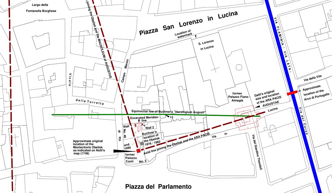
"Fig. 3.8. Detail of the map shown on Fig. 3.5. Map of the Campus Martius showing the area, where the
Montecitorio Obelisk and the Ara Pacis were found, with integration of Guglielmo Gattiʹs reconstruction of
the Ara Pacis.The map is oriented so that North is in the middle of the top border, or in other words, it is oriented
according to `grid north´. The grid is based on the following coordinate system: Roma 1940 Gauss Boaga Est
with a transverse Mercator projection. This map shows the output displayed by the ʺAIS ROMAʺ without
cartographic revision. The text relating to this map is continued on p. 106."
Original Fig. 3.8 = FORTVNA PAPERS II, 2017, Seite 105
Originaltext FORTVNA PAPERS II, 2017, Seite 106:
"The Mausoleum Augusti is drawn after the photogrammetric data. G. Gattiʹs reconstruction and location of the
Ara Pacis was copied after F. Filippi 2015, Tav. II (drawing: A. Blanco, D. Nepi, A. Vella), and drawn with
thin red lines. The centres of the Mausoleum and of the Ara Pacis are indicated by thin black broken lines that
intersect each other at a right angle. The original location of the socle of the Montecitorio Obelisk, as marked
on the second version of G.B. Nolliʹs large Rome map of 1748 (cf. here Fig. 3.1b) is drawn as a red area,
measuring ca. 3 x 3 m; label: Approximate original location of the Montecitorio Obelisk as indicated on
Nolliʹs map (1748). The (erroneous) original location of the Montecitorio Obelisk which was suggested by E.
Buchner in all his publications (1976; 1980; 1982; 1996a; 2000b) is indicated as a grey area, measuring ca. 3 x 3
m; label: Buchnerʹs locations of the Obelisk 1976/1982 and 1995; ‐ ʺand 1995ʺ refers to the socle of the
Montecitorio Obelisk, measuring ca. 3 x 3 m, surrounded by a bench on all sides (measuring ca. 7.70 x 7.70
m). Both are drawn with thin red broken lines and appear immediately to the west of Buchnerʹs first
suggested location for the Obelisk. This, his second location of the Obelisk with its bench, which Buchner
never published himself, was copied for this map after a plan first published by Buchnerʹs collaborator, G.
Leonhardt in 2014 (cf. id. 2014, 102, Fig. 1: drawing: G. Leonhardt 1995). Also the section of the Meridian
floor, comprising part of the Meridian line and its two bordering walls, was drawn after this plan; labels:
Wall 1; Excavated Meridian line; Wall 2. The equinoctial line of Buchnerʹs ʺHorologium Augustiʺ is drawn
with a green line, the imaginary axial lines joining the Obelisk and the Mausoleum of Augustus, and the
Obelisk and the Ara Pacis, are drawn with thick purple broken lines. The Via Flaminia/ Via Lata is drawn with
a 3 m wide dark blue line.
Cf. chapter II; The integration of Augustusʹ Meridian floor into the ʺAIS ROMAʺ and the orientation of the Saepta;
Again Augustusʹ Meridian floor and G. Gattiʹs reconstruction of the ʺCampo Marzio centraleʺ: his location of the
Saepta, and some new observations concerning the Iseum Campense; Appendix 2; chapter VII. SUMMARY: What
is left of E. Buchnerʹs hypotheses concerning his `Horologium Augusti´?; and the Contribution by F.X. Schütz in
this volume. For the locations of the two socles of the obelisks, as well as the two smaller foundations, all of
which stood on either side of the entrance to the Mausoleum Augusti, cf. now chapter VII; Post scriptum.
This map is based on the official photogrammetric data of Roma Capitale which appear in the background.
They were generously provided by the Sovraintendente ai Beni Culturali of Roma Capitale. C. Häuber,
reconstruction. This map was made with the ʺAIS ROMAʺ (C. Häuber and F.X. Schütz 2017)."
Originaltext Seite 591 aus dem Kapitel "VII. SUMMARY: What is left of E. Buchnerʹs hypotheses concerning his `Horologium Augusti´?":
"When we look in Fig. 3.7 at the positioning of the Montecitorio Obelisk/ Meridian and the Ara Pacis, which
are likewise interconnected by means of their (imaginary) axial line, those two monuments seem at first glance to be much less `important´ within
the overall design - in case there was anything like that at all (but see now a statement by E. La Rocca 2015a, VII, quoted below) - almost like
a mere Nebenschauplatz (`sideshow´). But, that is, of course, a matter of perspective. Because someone standing for example to the
south-east of the Montecitorio Obelisk and the Ara Pacis (at their original sites), approximately in the middle
between those two monuments, who looked north-west towards the Mausoleum, would have seen only those
three monuments (cf. here Fig. 3.8). This latter observation leads us to the question, raised by some
scholars [with note 338], whether Mausoleum, Montecitorio Obelisk and Ara Pacis were arranged in a right triangle. As a matter of fact,
this question can now be answered with: `most probably´, yes. Because the original location of the Montecitorio Obelisk, as indicated on Nolliʹs large Rome map (1748),
that we have integrated into our maps, is `most probably´ not far away from its true location [with note 339]. Under `normal circumstances´ [with note 340], I always trust
Nolli - also on my maps Figs. 3.5-3.10 the Obeliskʹs socle, as indicated on Nolliʹs map, is coloured red to indicate: ancient structure (meaning by
implication: at its correct location). But in this case, I rather wait for more evidence to come forth, verifying Nolliʹs location, considering the fact that
the Montecitorio Obelisk was used, together with its pertaining Meridian line, as a scientific instrument. Therefore, the lettering referring to Nolliʹs location
of the Montecitorio Obelisk on my maps 3.6-3.10 reads: Approximate original location of the Montecitorio Obelisk as indicated on Nolliʹs map
(1748) ‐ but see below.
In order to check, whether the three monuments discussed in this study were arranged in a right triangle, I have made two tests".
Note 338: "for example by Heslin 2014, 41 [2011, 75]; cf. Frischer and Fillwark 2014, 84-85. Of course already Buchner 1982,
365 Fig. 19 (= id. 1976, 365 Fig. 19) had visualized this idea in a plan. This was confirmed by La Rocca 2014, 123, Fig. 1 (= Buchnerʹs Fig. 19)".
Note 339: "so Frischer 2017".
Note 340: "cf. Häuber, Schütz 2004, 62-64, Fig. II.2; id. 2006, passim; Häuber 2014, 12, 14, 15, 16-17, and
passim".
On pp. 591-594 in the original Text these two tests are described.
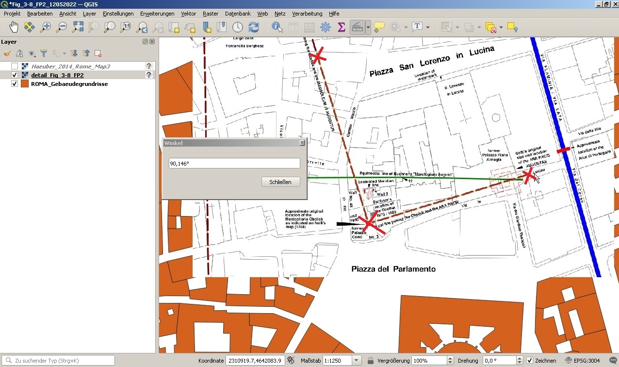
Originaltext Seite 597:
"Post scriptum
After this chapter was written, Amanda Claridge was so kind as to send me her contribution for this volume,
infra, p. 663ff. She asserts that the axial purple broken lines, drawn on my maps Figs. 3.5, 3.8‐3.10, that
connect the Mausoleum Augusti, G.B. Nolliʹs location of the Montecitorio Obelisk and G. Gattiʹs Ara Pacis
with each other, do not meet each other at a right angle at the Obelisk, but does not say, how she has
measured this angle. Measured in the ʺAIS ROMAʺ, these lines actually meet at a right angle. For the
projection we use, as well as for all kinds of possible problems involved when generating or using digital
maps, see the Contribution by Franz Xaver Schütz in this volume, infra, p. 691ff.
As mentiond above, we have so far a problem to locate the ground‐plans of the four foundations, remains of
which have been excavated in front of the Mausoleum Augusti (cf. here Figs. 3.5; 3.7; 3.8), two of them carried
the obelisks, the function of the two smaller foundations is disputed. This problem derives from the fact that
the available published plans do not show enough of the surrounding modern buildings or street fronts, that
would allow to find the necessary number of pass points in order to georeference these plans in reliable
fashion. Hoping that these colleagues had perhaps already come across the same problem, we made on 28th
September 2016 an appointment with Mirella Serlorenzi, Direttore Museo Nazionale Romano,
Soprintendenza Speciale, who directs the project `SITAR´, and met with her collaborators Andrea De
Tommasi, Arguna Cecchetti and Emanuela DʹIgnazio, in order to discuss the matter. For the same reason we
met on 30th September 2016 with Susanna Le Pera and Luca Sasso DʹElia, our co‐operation partners of the
project `Nuova Forma Urbis Romae´ of Roma Capitale. After meeting with all those specialists, who so far
have not themselves tried to map these specific details, we all agreed upon the following: we can only hope
that there is so far unpublished pertaining archival material, which contains such data, so that the correct
location of those features may be possible in the future."
Corrigendum:
In FORTVNA PAPERS II, 2017, Seite 597 ist der Name von ARJUNA CECCHETTI leider falsch geschrieben.
Mirella Serlorenzi sei herzlich für diesen Hinweis gedankt.
Datenschutzerklärung | Impressum
