Franz X. Schütz
This paper deals with digital modeling, reconstruction and visualization of urban landscapes, especially with the City of Rome. A new model is presented here: the landscape(t)-model. I will give a short summary of current attempts to model, reconstruct and visualize (ancient) Rome or parts of the City. A short overview on the development of digital spatio-temporal methods, especially on databases and technology of geographic information systems (GIS) is given to see the differences between conventional methods and my object-oriented approach concerning the landscape(t)-model. Apart from this I will present some other research questions and current subjects in geography like resources (urban mining) and sustainability in urban spaces, where geographers, archaeologists, historians and scholars from many other disciplines can work together in a very fruitful way. A central question in that research will be: what can we learn from the past for future developments? Such research needs an interdisciplinary, integrative approach with special attention to the human impact on cityscapes and the integration of archaeological and historical evidence.
Keywords: Geography, Archaeology, History, Landscape(t)-model, object-oriented database, reconstruction, Rome, Spatial Information Science, spatio-temporal modeling, sustainability, urban research, urban mining, visualization.
The area in which I tested the landscape(t)-model is located on the Esquiline Hill in the City of Rome. Fig. 1 shows the photogrammetric data of Rome within the Aurelianic City Wall with my test area highlighted in blue colour on the Esquiline Hill. I have chosen this area because Chrystina Häuber is conducting research on this area since 1981 (HÄUBER 1983) and because she provided me with many archaeological and historical data and information concerning this area. Since the last 20 years we are working together in this area. In VENTRIGLIA (1971), GIOIA (2004) and HEIKEN, FUNICIELLO, DE RITA (2005) we find a summary of the development from ca. 5 million years ago until today of the area of the current City of Rome from a geological perspective. An overview of the development of the city from a geographical perspective gives PASQUINELLI D'ALLEGRA (2007). CLARIDGE (2010) wrote about the City from an archaeological viewpoint.
Fig. 2 shows the area on the Esquiline Hill between the two buildings "Sette Sale" and the so-called "Auditorium of Maecenas". On Fig. 2a we see the photogrammetric data with an orthophoto as overlay as it looks like today. On Fig. 2b we see the same photogrammetric data with an overlay of Nolli‘s map (1748).
Fig. 1: The photogrammetric data of Roma Capitale within the Aurelianic City Wall with the test area
")
Fig. 2a: Detail of the test area, photogrammetric data and orthophoto (2012),
2b: Detail of the test area, photogrammetric data and Nolli’s map (1748)
Nolli's
map
is very
accurate and all "dark"
buildings are ancient structures (cf. for Nolli and GIS, BRIENZA
1998). We see on Fig.
2b that
at Nolli’s time the "Auditorium of Maecenas" was
covered with earth. Only parts of the "Sette Sale" were
visible. The
page 109
"Auditorium" was excavated in 1874, see below
and Fig.
5a.
I have chosen this area to demonstrate some functionalities of my
landscape(t)-model, such as spatio-temporal modeling, reconstruction
and visualization.
Modeling, Reconstruction and Visualization
Visualizations of the City of Rome were already created in antiquity. One in fragments still existing example is the "FORMA VRBIS ROMAE" (or "Forma Urbis Marmorea"), the Severan marble plan of Roma created at the time of the Roman emperor L. SEPTIMIUS SEVERUS (cf. OBERHUMMER 1907; Carettoni, Colini, Cozza, Gatti 1960, see also LA ROCCA in this book Fig. 1, p. 28 and Fig. 7, p. 32). On this marble plan the regions of Rome are indicated and until today Rome is divided into regions, today called "Rione", e.g. rione Esquilino.
With the development of new digital technologies it became possible to create digital models and visualizations of the City of Rome. According to LONGLEY, GOOD-CHILD, MAGUIRE, RHIND 2011, p. 404 "spatial models" have two key requirements: "1. There is a variation across the space being manipulated by the model" and "2. The result of modeling change when the locations of the objects change--location matters". The authors also point out that "Models do not have to be digital, and it is worth spending a few moments considering the other type, known as analog" (p. 404).
My idea to reconstruct the ancient landscape of Rome (as a digital model) is of course not new. For the field Geography I should like to mention for example Karl Diwald who was a geomorphologist from Vienna. His idea was to collect all information concerning "ruins" ("Ruinen") and all information pertaining excavations of the past ("aller erreichbaren früheren Grabungen") in the City of Rome. Unfortunately he died before he could publish his material. Armin von Gerkan published some of the research he had conducted together with Karl Diwald (GERKAN, 1952 p. 393) and later gave the material to Prof. Kirsten, then Institut für Historische Geographie und Antike Topographie der Universität Bonn (cf. GERKAN 1952, p. 433).
Lorenzo Quilici was in the 1960s one of the first, who, obviously paper-based ("analog", see above), tried to reconstruct the morphology of archaic Rome. His work has the title "Forma e Urbanistica di Roma Arcaica", cf. QUILICI (1990). Quilici quotes LUGLI 1951 and VENTRIGLIA 1971 as references for the changes of the geomorphology within the current area of the City of Rome. In QUILICI, 1990, p. 30 appears a map drawn by hand (L. QUILICI 1967), carrying the title "1 - Ricostruzione morfologica del suolo primitivo di Roma". In his figure 2 he shows an overlay with the current situation. This map has the title "2 - Proiezione della situazione topografica attuale sul piano di fondo dato alla figura precedente" and is signed: "LORENZO QUILICI - STEFANIA QUILICI GIGLI - 1974".
FACCENNA,
FUNICIELLO, MARRA (1995) have tried to visualize the morphology of
the area of the City of Rome before humans appeared. This 2D
visualization has the caption: "Fig. 13. - La morfologia
dell'area della città di Roma come doveva apparire
page 110
prima che
l'uomo, attraversa la propria attività millenaria, modificasse
i caratteri del paesaggio naturale" (FACCENNA, FUNICIELLO, MARRA
1995, p. 46).
HASELBERGER (2002, p. 28) mentions in the preface of his book "Mapping Augustan Rome" four "current digital projects". He used for the creation of the visualizations published in his book the software AutoCAD (cf. ROMANO et al. 2002, p. 31) and "surfer", using kriging interpolation (ROMANO et al. 2002, p. 32). Contrary to HASELBERGER who used as "primary basis" for his map "a set of 1 : 10 000 maps" (ROMANO et al. 2002, p. 29) my data basis are the official photogrammetric data of Roma Capitale in the scale 1:500.
The book ROME REBORN accompanied "an exhibition at the Library of Congress, January 6-April 30, 1993" (GRAFTON, p. vi). In this book we find many "analog" models and reconstructions of the City of Rome. Later a project directed by FRISCHER was also called "Rome reborn" (cf. WELLS, FRISCHER, ROSS, KELLER 2010). In this project the authors try to reconstruct the ancient City of Rome at the date "A. D. 320". The basis of this digital model is the large wooden model created by Italo Gismondi ("plastico di Roma in scala 1:250, il più grandioso (m2 200) ... iniziato per la Mostra augustea della Romanità nel 1937" TCI 1999, p. 833). There is no solid spatial basis, as noted by the authors themselves: "but since the Rome model was not georeferenced, the model would not export correctly" (p. 375). The authors describe also that they have tried to integrate their models into google earth: "Another problem arose from a conflict between the historic and current terrain of Rome. The terrain in and around the city has changed drastically in places over the past 2,000 years, both from natural causes and human intervention, to the point that a recreation of the terrain in A.D. 320 does not easily sit on the modern landscape. After some debate, Google Earth suggested that the historic terrain, and the 3D model, be suspended 40 meters above the ground." (p. 375). Let me add that in this project an earlier version of a software now called CityEngine was used for the generation of the models.
Another project, called "Virtual Rome", is described in PESCARIN et al. 2010. The authors try to reconstruct historic landscapes of Rome using as "back-end section ... a MySQL database" (PESCARIN et al. 2010, p. 311). They offer models generated for fixed dates.
TESTA, CAMPOLUNGHI, FUNICIELLO, LANZINI (2008) are discussing the problems of the changes caused by humans (cf. "Il problema dei riporti e le modificazioni della forma originaria" pp. 145-168). Their reference is the "map of Quilici 1990", who tried to reconstruct the ancient landscape in 2D (this map dates to 1967, see above and is still regarded as a standard ). On page 160 of TESTA et al. 2008 we will find a digitized map (the scale is ca. 1: 25,000): "Fig. 13 - Dalla digitalizzazione delle curve di livello della carta altimetrica del Quilici si è ricavato il D.E.M. a 5m della città di roma prima della fase antropica".
AMANTI,
CARA, PECCI 1995 published a shaded relief map, showing the current
surface of the historic center of Rome within the Aurelianic City
Wall. This model is based on a database of measured points all over
the city and was created with a TIN using ESRI ARC/INFO Rel. 6.0 (cf.
AMANTI, CARA, PECCI 1995, pp. 317, 321).
page 111
According to the authors
this is the first scientific digital model of the morphology of the
city. This model is still used in scientific publications, for
example by FUNICIELLO, HEIKEN, DE RITA, PAROTTO 2006 as "TAVOLA
II" (after p. 44).
PANELLA has published a new simulation of the spreading of the great fire in Rome in the year 64 AD ("Simulazione del propagarsi dell'incendio tra il 18 ed il 27 Iuglio del 64 d.C." PANELLA 2011, p. 87). In this simulation the progress of the fire by day was drawn in different shades of yellow/red.
In the proceedings of a conference on the "SITAR. Sistema Informativo Territoriale Archeologico di Roma" (SERLORENZI 2011, CARAVALE 2011) was described the current state of digital projects for the City of Rome.
Since 1994 I am conducting together with the Classical Archaeologist Chrystina Häuber and further cooperation partners interdisciplinary research on the City of Rome. Based on the object-oriented software FORTVNA, which we developed for the purpose ourselves, we try to model, reconstruct and visualize parts of the City of Rome. The objective of our project AIS ROMA is to draw a diachronic map of the City of Rome within the Aurelianic City Wall (cf. HÄUBER, SCHÜTZ 1997, SCHÜTZ, HÄUBER 2001, SCHÜTZ, HÄUBER 2003, SCHÜTZ 2010, SCHÜTZ 2013, www.rom.geographie.uni-muenchen.de [last visit: 16-XII-2014]).
To sum up, we can say that already in the past many projects have tried to reconstruct and model the entire City of Rome or parts of the city, others still try this today. For most of these applications commercial or free available software are used. This means that the relevant data have to be "pressed" into relational or other (older) data structures.
The objectives of the above mentioned projects and the methodology applied for them are very different. Many projects are still paper-based ("analog") - which is absolutely sufficient for many research questions. In some of these projects the aim was to model a specific historical phase of the area of the City of Rome, in other projects the development of the layout and/or the landscape of Rome was visualized. Some of these projects have a distinct scientific approach, others clearly not. The objectives of my own research projects can be characterized like this: I want to model continuous spatio-temporal phenomena in 3/4D, based on official (accurate) data ("3D" indicates the spatial dimension, "4D" the temporal dimension). "However, hitherto there is no ready-to-use 3D/4D geodatabase system on the market" (BREUNIG, SCHILBERG, THOMSEN, KUPER, JAHN and BUTWILOWSKI 2010, p. 83).
The landscape(t)-model - a digital method for modeling spatio-temporal phenomena
For the creation of digital models we need digital methods. In Geography these are mainly methods based on GIS-technology (Geographic Information Systems). The first GIS, called CGIS was published by Roger TOMLINSON (1976). Concerning the modeling of urban areas TOBLER published already in 1970 "A Computer Movie Simulating Urban Growth in the Detroit Region" (TOBLER 1970).
Since 1994, when I was a student of Geography, I am developing and using GIS-technology. In August of 1994 Chrystina Häuber told me about her archaeological research in the City of Rome and I told her about my work using GIS-methodology. Her first question was whether it is possible to reconstruct the ancient landscape of the City of Rome with the help of computers. You can read the results of this question in this book.
Since the last 20 years GIS-technology developed very fast and today it is a science in its own right, called Spatial Information Science (cf. GOODCHILD 2010). Concerning digital 3D-Visualizations, especially in urban areas today international standards are established like the OGC (Open Geospatial Consortium, cf. OGC 06-103r4; www.opengeospatial.org [last visit 16-XII-2014]) or the CityGML-Standard (cf. www.citygml.org [last visit 16-XII-2014]). Concerning more technical aspects of reconstructions the London Charter is very important. "The London Charter seeks to establish what is required for 3D visualisation" and "seeks to establish principles for the use of computer-based visualisation methods and outcomes in the research and communication of cultural heritage..." (www.londoncharter.org, seen 17-X-2012). In the London Charter detailed instructions are given how scientificly valid computer-based visualizations of cultural heritage can be created.
The basis of a Geographic Information System is in most cases a spatial database. So far different data models have been developed, each of which has advantages and disadvantages. In the historical order the important data models are: 1966 the "file system", 1968 the "hierarchical model", 1970 the "relational model", 1980 the "object-relational model" and 1983 the "object-oriented model" (cf. HÄUBER, SCHÜTZ 2004, p. 39). The relational model - the most important until today - was developed and published by CODD 1970. CODD writes in his acknowledgment that C.T. DAVIES convinced him of the fact of the independence of data in future information systems (cf. CODD 1970, p. 387). DATE (1986, pp. 179-202) compares the relational model with the hierachical model and gives a comprehensive account on relational databases. Since the 1980s scholars discuss an object-oriented approach with an object-oriented database in the background (cf. EGENHOFER, FRANK 1989, ATKINSON, M. et al. 1989, KIM 1990, KJENSTAD 2006).
Despite the research conducted since the 1980s, there are still many problems concerning spatio-temporal modeling in urban spaces. For example GOODCHILD (2001, p. 248) writes: "Three major impediments are identified to further development of the digital city: the lack of a common, integrated data model; the difficulty of modeling continuous phenomena in object-oriented data models; and the variable accuracy of diverse data sources". This is still true today. According to LESER, CONRADIN (2008, p. 21) there are still currently only a few part-models for spatio-temporal modeling of urban spaces: "Ideal wären komplexe rechenbare stadtökologische Modelle für räumlich umfassendere und über längere Zeiträume angelegte Stadtentwicklungen. Bislang lediglich in Teilmodellen ausnahmsweise realisiert". These two statements have been one motivation and starting point for me to develop the "landscape(t)-model".

Fig. 3: Comparison of relational/object-relational and object-oriented databases
(source: GREHAN s.a., p. 5)
Fig. 3 shows the difference between relational database management systems ("RDBMS") and object-oriented databases ("db4o"). The great advantage of an object-oriented database is that you can transfer the data model (the "objects") directly into the database (see Fig. 3 "db4o") instead of "pressing" them into relational structures (see Fig. 3 "RDBMS"). Object-oriented databases have a totally different concept than relational and object-relational databases. For the main differences between relational (tables), object-relational (tables) and object-oriented databases, cf. PATERSON, EDLICH, HÖRNING, HÖRNING (2006, p.4) who quote Esther Dyson: "Using tables to store objects is like driving your car home and then disassembling it to put it in the garage. It can be assembled again in the morning, but one eventually asks whether this is the most efficient way to park a car". KIM (1990, pp. 3-10) argues that complex data including the spatial and temporal dimension can not efficiently be handled with a relational approach. The idea behind the landscape(t)-model is that each point on the surface of the earth can change its attributes in time by natural events (water, natural hazards ...) or by human influence (digging, building work ...).
Fig. 4 shows the main classes/ the concept of the landscape(t)-model. I used "The Unified Modeling Language" (UML, cf. BOOCH et al. 2005) for modeling the classes of my landscape(t)-model. UML is object-oriented, and can be used for a direct implementation in an object-oriented programming language like C++ or Java. The starting point is the Gpoint class with an x(-coordinate), an y(-coordinate), a z(height above sealevel), and a t(ime) attribute. There are also some more attributes, for example accuracy and methods for this Gpoint object like draw(). The next class is "Human". With this class it is possible to model human objects. Humans have attributes like birthday, name and so on. The class "Human" inherits all attributes from the class Gpoint. On principle, each "Human" has at any given time (t) an x,y,z-coordinate, which, thanks to the object-oriented "philosophy" of the landscape(t)-model can now be visualized. We can thus "model" humans on the surface of the earth, also in a dynamic way because all of the just mentioned attributes can change over time. In the future it should be possible to use all objects as input for simulations, for example simulating "processions" or "traffic" in ancient Rome using the objects "Humans" and "Streets".
-model")
Fig. 4: main classes/concept of the landscape(t)-model
In addition to the already mentioned ones, the landscape(t)-model has among others the following classes: Surface, Street, Building. All these classes inherit attributes from the Gpoint class. This enables us for example to model the changes of the surface of the earth by humans. Another class, called "Landscape", inherits attributes from all other prior classes. Only by considering the classes Humans, Streets, Buildings etc., we can model the landscape at a fixed date (t), for example for the year 8 B.C.; and based on such a model we can then visualize the landscape in question at the defined time "t". Using a dynamic variable for "t", we can additionally model the spatio-temporal development of a landscape, the "moving landscape".
In theory (see above, TOBLER 1970!, TOBLER 2000), all this sounds very simple. The application to a "real" example is quite a different matter. The problem here lies of course in the fact that we need for an enterprise like this a huge amount of (continuous) data in the data base. In the following I will show you a preliminary model and visualization using as my example the so-called Auditorium of Maecenas.
Example: The so-called "Auditorium of Maecenas"
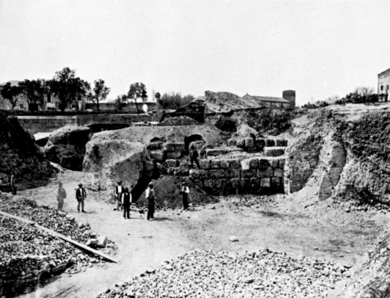
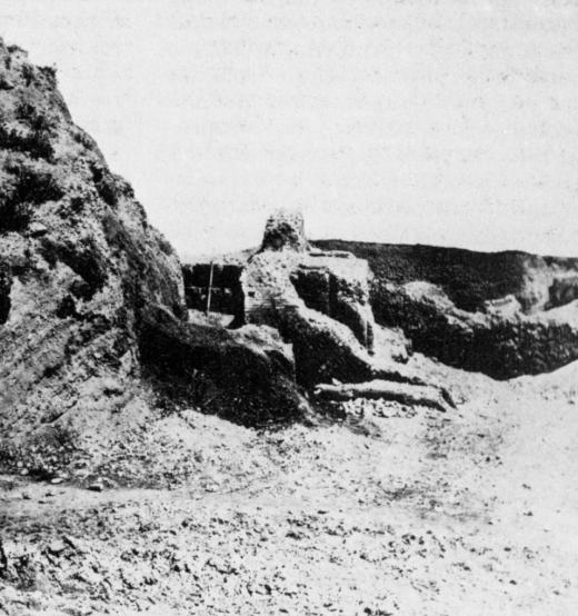
Fig. 5a shows one of the photos taken during the excavation of the so-called "Auditorium of Maecenas" in 1874. In the background we can see a church and some buildings that are still standing. Thanks to the fact that these buildings could be identified, we can be certain where the photographer was standing when he took the photo, and this means that the ancient building visible in the foreground is the so-called Auditorium of Maecenas. This was thoroughly published in 1874 by its excavators, who described in detail its relation to the surrounding landscape and still exists today.
|
Fig. 5a Photo Parker (source: a: COMUNE DI ROMA 1989, p. 210 (1874) |
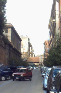
Fig. 5b (2010) |
|
|
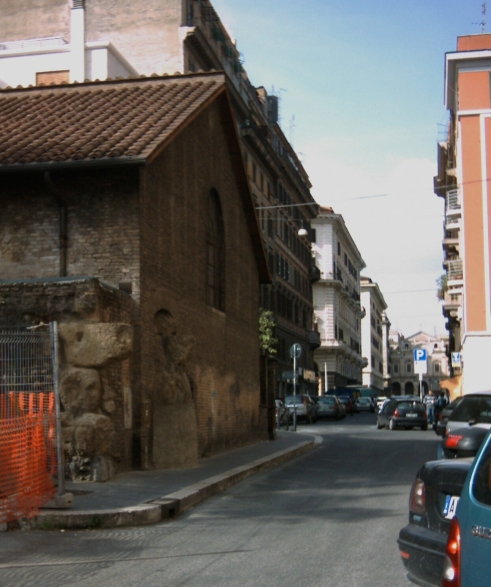
Fig. 5c (2004) |
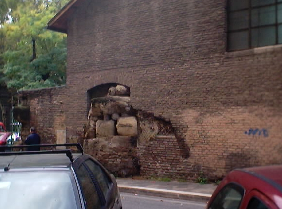
Fig. 5d (2000) |
|
Fig. 5a-d:The so-called Auditorium of Maecenas
Fig. 5b shows that the "Auditorium" protrudes into the modern road Via Leopardi. The two photos Fig. 5c and 5d show the "Auditorium" as it looks like today with remains of the Servian City Wall, into a gap of which the "Auditorium" was built. Assembling and analysing the relevant spatio-temporal data in the landscape(t)-model we can visualize the "moving landscape" around the "Auditorium".
The landscape(t)-model was implemented by using the object-oriented database db4o and the programming language Java, which is portable and independent from the operating system. This programming language is widely used for implementing GIS-technology (cf. WOOD 2002, GREHAN s.d., HERTER, KOOS 2006, LEONE, CHEN 2007). The prototype is called GIUrbs and is part of the research project AIS ROMA (cf. HÄUBER, SCHÜTZ 2004, p. 61, HÄUBER, SCHÜTZ 2010).

Fig. 6: "Moving landscape" in the area of the "Auditorium of Maecenas". Right: Detail of preliminary Visualization.
In Fig. 6 appears a preliminary visualization of the "moving landscape" around the "Auditorium". The green dots are measured points with x,y,z and t-coordinates. Other components of this picture are the current orthophoto (see Fig. 2a) and a reconstruction of the "Auditorium" with a "photo texture" on that side into which the remains of the Servian City Wall are integrated (see Fig. 5d). Above the "Auditorium" appears the relevant detail of Nolli's map (1748). At that time the "Auditorium" was still covered by a mound of earth (see Fig. 2b). In this visualization the "Auditorium" is the fixed "point" and the landscape is moving around it from 1748 until today. This state of the visualization does not yet comprise the phases between the time of Maecenas (end of the 1. century BC), who built the "Auditorium", and Nolli's map of 1748.

Fig. 7: Changing groundlevels at the Piazza Vittorio Emanuele II
Fig. 7 shows another example for a "moving landscape" at the north corner of the square Piazza Vittorio Emanule II (see also Fig. 1). We see two ground levels that have been changed in 1876; one with a tree (Fig. 7 right from the back side with the "Porta Magica" cf. HÄUBER, p. 48-67 in this book), which is the remainder of the previous ground level, and the current one (Fig. 7 left from the front side), the difference in height is about 3 m (z-coordinate).
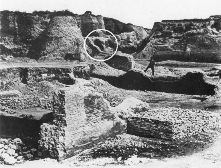
As a result of my research on photos of the collection Photo Parker I found two photos with unknown location. We see those photos on Fig. 8.
|
|
|
Fig. 8: Excavating the Esquinline (Photo Parker, source: left: SARTORIO 1983, p. 103, right: RAMIERI 1983, p. 23)
Comparing these photos that were taken during the building works in the late 19th century on the Esquiline Hill with other images and my preliminary visualizations, I found out that they contain the same structure (Fig. 8, right and structure in white circle on Fig. 8, left). I am convinced that in the end I will be able locate this structure very precisely in the photogrammetric data (see Fig. 1). Currently most scholars in the fields of archaeology and history believe that this is impossible. I think that it will be possible by using an interdisciplinary, integrative approach and methods from spatial information science. If it were possible to locate all the structures that are visible on those photos precisely this could become another important source on which we could base reconstructions of the "moving landscape" of the Esquiline Hill.
The focus of this paper was so far on the description of an object-oriented data model for 3/4D-modeling and visualization. When applying this model to the visualization of the historical landscape of Rome we saw different "levels" of landscape, derived from diverse sources and we have seen that a huge amount of earth had been moved in the course of time (see Fig. 6). The human impact in changing the surface of the earth is visible since antiquity and reached a new dimension with the beginning of industrialisation. I have discussed the following in SCHÜTZ 2013 in detail. Early works on the subject have been written by MARSH (1864) and SHERLOCK (1922). One of the first works concerning human impact in urban environments is SHERLOCK 1922 with his book "Man as a geological agent - an account of his action on inanimate nature". He analyses the human impact in the City of London and comes to the conclusion that in the City of London there is about 20 to 25 feet of débris and earth above the Roman ground level (SHERLOCK Chapter V, "London", p. 157-189). On p. 189 SHERLOCK (1922) wrote that "Exploration of ancient cities in various parts of the earth has shown that on the average they deposit a foot of débris per century, and this agrees with what we know of London". It would be a very interesting research topic to investigate and calculate all the documented "movements" of earth and débris on the Esquiline Hill in the City of Rome from antiquity until today (see below). Also GOUDIE (1987) is working on questions about the human impact changing the landscape (cf. GOUDIE 1987: "2 Geography and Archaeology: The Growth of a Relationship". He is a geomorphologist and in 2006 was published the 6th edition of his book "The Human Impact on the Natural Environment: past, present, and future".
RATHJENS
(1979) wrote the first book in German dealing with the human impact
on the landscape which has the title "Die Formung der
Erdoberfläche unter dem Einfluß des Menschen: Grundzüge
der Anthropogenetischen Geomorphologie". He has pointed out that
research in this field needs an interdisciplinary and integrative
approach and is also a bridge between physical and human geography:
"Zum Verständnis und zur Deutung anthropogener Formen
bedürfen wir aber vielfach auch der Hilfe anderer Wissenschaften
und Wissenschaftszweigen ... Die Untersuchung der vom Menschen
beeinflußten Oberflächenformung wird damit zu einem
wichtigen Bestandteil und einer Aufgabe der Geographie, in der sie
eine Brücke zwischen Natur- und Kulturgeographie schlagen hilft"
RATHJENS (1979, p. 17). DEVOTO (1985) gives some examples for changes
of the morphology by human impact, especially in his chapter
"Geomorfologia e archeologia" (chapter 6, pp. 151-171). He
mentions for example some hills constructed by humans like the "Monte
Testaccio" in Rome ("6.11. Geomorfogenesi antropica"
... "L'accumularsi di spessori talora enormi di detriti di
page 119
discariche, sia in forma di veri butti ... sotto forma di colline
artificiali, quali ad esempio il celeberrimo Monte Testaccio a Roma
(da testa: cocci di ceramica) e i già ricordati accumuli di
scorie ferrose etrusche del litorale toscano presso Piombino. Anche
la costruzione di tombe monumentali può influire direttamente
sulla morfologia: ne sono esempi classici i meloni di Cortona, i
monterozzi di Tarquinia, i tumuli di Cerveteri." p. 170). LESER,
CONRADIN (2008, p. 33) demonstrate with figure "Abb.
3.1.1.2.1-1: Entstehung flächenhafter Vollformen I: Aufhäufung
von Kulturschutt" how humans are changing the urban landscapes.
Other unresolved questions are concerning the calculations of the "real" landscape at a certain date/period and site in antiquity. Currently there are very few attempts to explore these questions in urban spaces. We could for example ask: where did the earth come from with which cemeteries on the Esquiline were covered at the time of Maecenas by several meters? What happened to the earth that was moved during the building works beginning in the 1870s on the Esquiline, e.g. the earth which covered the so-called Auditorium of Maecenas? These are very interesting questions, especially for the fields geography (see above) and geomorphometry (cf. HENGL, REUTER 2009). John Bodel (cf. BODEL p. 177-195 in this book) is dealing/interested in similar questions from the perspective of ancient history. But not only reconstructions of ancient structures and urban landscapes which are the result of human impact in the past can support geographic research. Many current themes in Geography, especially in urban geography have a close relationship to history and archaeology.
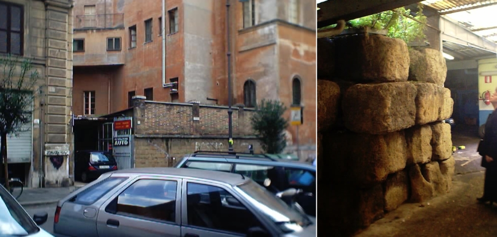
Another field of research, so far predominantly discussed in urban geography, is "gentrification" (= transformation of buildings "into luxury apartments" PACIONE 2001, p. 202), As the here chosen example shows, it is equally of interest for historians and archaeologists, as the author found out in recent discussions. I show you one example from the Esquiline Hill in Rome. Some years ago we found in Via Mecenate (see also Fig. 2) a garage ("Carrozzeria Riparazioni Auto") with remains of the Servian City Wall (Fig. 9, left).
|
|
|
Fig. 9: One example of "gentrification", Rome, Via Mecenate (left: 2000, right: 2010).
Much building work has recently been conducted in this quarter of the Esquiline. As the comparison of Fig. 9a with 9b demonstrates this section of the city wall has recently been restored. This occured in conjunction with the building of new "luxury apartments".
Let us now turn to another important research field in geography. Since Habitat II (the UN-conference on human settlements in 1996) the subject sustainability in urban spaces and their hinterlands is an integral part of research in historical, urban and regional geography (cf. FUSCO GIRARD et al. 2003, HALL 2003, ZAMAGNI 2003, MAZZOLA et al. 2010). Currently about 60% of humans live in such spaces, and the number is increasing. Until now computer-based methods, models and simulations for the development of such very complex spaces for both growing and shrinking cities do not exist, as we have seen before. If it were possible to simulate the development of a city like Rome this could efficiently support the creation of sustainable strategies concerning urban planning and urban development. A central question in this kind of research will be: what can we learn from the past for future developments? Such research needs an interdisciplinary, integrative approach (cf. GOUDIE 2006) with special attention to the human impact on cityscapes and the integration of archaeological and historical evidence. As ZAMAGNI (2003, pp. 133) comments: "without overcoming the limitations of scientific research that is too `sector-oriented´ and too little trans-disciplinary, the `new alliance´ between mankind and nature - to use the ichastic expression of I. Prigogine - will never be able to be achieved".
"Urban Mining" (RELLER 2013, p. 218) is currently a growing subject in the research fields resource management and resource strategies. This field is of special interest for urban geography. In topics that explore resources the spatio-temporal dimension is very important ("13.1.3 Die raum-zeitliche Dimension" RELLER 2013, p. 214), especially because of its potential to trace resources for example minerals, stones etc. in space and time (cf. "Traceability" RELLER 2013, p. 217). In my opinion we can use the object-oriented landscape(t)-model as a framework also in research topics that are focused on resources. Because of its object-oriented approach - as I have tried to demonstrate in this contribution (see above) - it is a much better tool than the relational-based tools used so far for this kind of research. We can thus model the spatio-temporal dimension very well and also "trace" the objects (resources) we are interested in.
Why work with geographers in reconstructions and visualizations of ancient Rome?
"As long ago as 1941, Carl Sauer described this process when he wrote 'the historical geographer must ... be a regional specialist for he must not only know the region as it appears today; he must know its lineaments so well that he can find in it traces of the past, and he must know its qualities so well that he can see it as it was under past conditions. One might say he needs the ability to see the land with the eyes of its former inhabitants, from the standpoint of their needs and capacities. This is about the most difficult task in human geography' (Leighly, 1963:362). Few archaeologists or landscape historians, particularly fieldworkers, would disagree with this sentiments." ROBERTS (1987, p. 81) . In my opinion computer based methods, like the landscape(t)-model can help - not only geographers - to reconstruct and visualize past environments, especially in urban environments like that of the City of Rome.
To conclude: considering major research questions in human (cultural) and physical geography, such as sustainability and resource management, it is plain to see that it is essential (not only fruitfull) for geographers to work with archaeologists, historians and scholars from many other disciplines.
Acknowledgements
I would like to thank Prof. Eugenio La Rocca for providing our research project AIS ROMA with digital data of the City of Rome in 1999, and the Sovraintendente Dr. Claudio Parisi Presicce for renewing this agreement in 2014, as well as Chrystina Häuber for many discussions.
References
ALDENDERFER, M., MASCHNER, H.D.G (Eds.)(1996): Anthropology, Space, and Geographic Information Systems. New York, Oxford.
ALLEN, K.M.S., GREEN, S. W., ZUBROW, E. B. W. (Eds.)(1990): Interpreting space: GIS and archaeology. London, New York, Philadelphia.
AMANTI, M., CARA, P., PECCI, M. (1995): Modello digitale della superficie reale del centro storico della città di Roma. In: FUNICIELLO et al. 1995, pp. 309-321.
ATKINSON, M. et al. (1989): The Object-Oriented Database System Manifesto. In: Proceedings of the conference on Deductive and Object-Oriented Databases (DOOD) (Kyoto 1989), pp. 40-57.
BENDER, O., EVELPIDOU, N., KREK, A., VASSILOPOULOS, A. (Eds.)(2009): Geoinformation Technologies for Geocultural Landscapes: European Perspectives. Boca Raton, London et al.
BOOCH, G., RUMBAUGH, J., JACOBSON, I. (2005): UML: The Unified Modeling Language user guide [thoroughly updated - the ultimative tutorial to the UML from the original designers; covers UML 2.0] The Unified Modeling Language user guide. 2nd ed., 2nd print, Upper Saddle River et al.
BREUNIG, M., SCHILBERG, B., THOMSEN, A., KUPER, P.V., JAHN, M., BUTWILOWSKI, E. (2010): DB4GeO, a 3D/4D Geodatabase and Its Application for the Analysis of Landslides. In: KONEČNÝ, M., ZLATANOVA, S., BANDROVA, T. L. (Eds.): Geographic Information and Cartography for Risk and Crisis Management. Berlin, Heidelberg: Springer-Verlag. pp. 83-101. DOI 10.1007/978-3-642-03442-8_6.
BRIENZA, E (1998): Cartografia storica e cartografia numerica. La pianta del Nolli e il GIS. In: BEVILACQUA, M. (1998): Roma nel secolo dei Lumi. Architettura erudizione scienza nella Pianta di G.B. Nolli «celebre geometra». Napoli: Electa Napoli. pp. 199-202, (Bibliografia pp. 203-214).
BROCCHI, G. (1820): DELLO STATO FISICO DEL SUOLO DI ROMA. MEMORIA PER SERVIRE D`ILLUSTRAZIONE ALLA CARTA GEOGNOSTICA DI QUESTA CITTÀ. DI G. BROCCHI. Con due tavole in rame. Roma MDCCCXX: Nella Stamperia de Romanis.
CARAVALE, A. (2011): Recensione: "M. SERLORENZI (ed.), SITAR, Sistema Informativo Territoriale Archeologico di Roma. Atti del I Convegno (Roma, Palazzo Massimo, 2010), Roma 2011, Iuno Edizioni." In: Archeologia e Calcolatori, 22, 2011, pp. 451-454.
Carettoni, G., Colini, A. M., Cozza, L., Gatti, G. (a cura di) (1960): La pianta marmorea di Roma Antica. Forma Urbis Romae. Roma.
CARTER, H. (1975): The Study of Urban Geography, 2. Ed. 1975, London.
CARTER, H. (1983): An Introduction to Urban Historical Geography. London.
CHENALL, R. (1968): The impact of computers on archaeological theory: an appraisal and a projection. In: Computers and Humanities 3, pp. 15-24.
CLARIDGE, A. (2010): Rome. An Oxford Archaeological Guide. With contributions by Judith Toms and Tony Cubberley. Oxford. Second edition, revised and expanded.
CODD, E.F. (1970): A Relational Model for Large Shared Data Banks. Communications of the ACM, 13(6), pp. 377-387.
COMUNE DI ROMA (Ed.)(1989): Un Inglese a Roma. 1864·1877. La Raccolta Parker nell'Archivio Fotografico Comunale. Roma.
CRAWFORD O.G.S. (1924): AIR SURVEY AND ARCHAEOLOGY. Ordnance Survey Professional Papers, New Series, No. 7. (I used the copy in The British School at Rome).
DATE, C.J. (1986): Relational Database: Selected Writings. Reading et al.
DEVOTO, G. (1985): GEOLOGIA APPLICATA ALL'ARCHEOLOGIA. Roma.
DORAN, J., HUDSON F.R. (1975): Mathematics and Computers in Archaeology. Edinburgh: Edinburgh University Press.
DYOS, H.J. (Ed.) (1968): The Study of Urban History. London.
EGENHOFER M.J., FRANK A.U. (1989): Object-oriented modeling in GIS: Inheritance and propagation. Auto-Carto 9 Proceedings. Baltimore.
FACCENNA, C., FUNICIELLO, R., MARRA, F. (1995): Inquadramento geologico strutturale dell'area romana. In: FUNICIELLO et al. 1995, pp. 31-47.
FELS, E. (1935): Der Mensch als Gestalter der Erde. Leipzig.
FRUTAZ, A.P. (a cura di)(1962): Le Piante di Roma I. II. III. Roma.
[FUNICIELLO et al. 1995] FUNICIELLO, R. (Coordinamento scientifico), AMANTI, M., BENCIVENGA, M. et al. (a cura di)(1995): La Geologia di Roma. Il Centro Storico. Roma. (= Memorie descrittive della Carta Geologica D'Italia, Volume L).
[FUNICIELLO et al. 2006] FUNICIELLO, R., HEIKEN, G., DE RITA D., PAROTTO, M. (2006): I SETTE COLLI. Guida geologica a una Roma mai vista. Milano (Edizione originale Grant Heiken, Renato Funiciello and Donatella De Rita, The Seven Hills of Rome, 2005, Princeton University Press)
FUSCO GIRARD, L. et al. (Eds.)(2003): The Human Sustainable City: Challenges and Perspectives from the Habitat Agenda. Aldershot et al.
GERKAN, A. v. (1952): Die morphologische Stellung des Palatins. In: Festschrift für Rudolf Egger zum 70. Geburtstag, Beiträge zur älteren europäischen Kulturgeschichte I 1952.Wieder abgedruckt in: BOEHRINGER, E. (1959): Von antiker Architektur und Topographie. Gesammelte Aufsätze von Armin von Gerkan. Stuttgart, pp. 393-430.
GIOIA, P. (a cura di)(2004): Elefanti a Roma. Roma.
GRAFTON, A. (Ed.)(1993): ROME REBORN. The Vatican Library and Renaissance Culture. Washington et al.
GOODCHILD, M.F. (2001): The Digital City: Inventory and Prospect. In: Urban Geoinformatics. International Conference Proceedings, School of Urban Studies, Wuhan University. Wuhan: Publishing house of Surveying and Mapping, pp. 248-257.
GOODCHILD, M.F. (2010): Twenty years of progress: GIScience in 2010 (Invited Keynote Article). In: Journal of Spatial Information Science, Number 1 (2010), pp. 3-20. doi:10.5311/JOSIS.2010.1.2 .
GOUDIE, A. S. (1987): "2 Geography and Archaeology: The Growth of a Relationship". In: WAGSTAFF 1987, pp. 11-25. (The Bibliography for all articles in the book is on pp. 192-228) .
GOUDIE, A. (2006): The Human Impact on the Natural Environment: past, present, and future. 6. ed. Oxford et al.
GREHAN, R. (s.d.): Whitepaper. db4o | Die Open Source Objektdatanbank | Java und .NET. The Database Behind the Brains. s.l., 13 pages.
HÄUBER, C. (1983): 7d. Ricerca sui confini e l´apparato decorativo degli Horti Mecenatiani. In: Roma Capitale 1870-1911, 7: L´archeologia in Roma capitale tra sterro e scavo. Venezia: pp. 204-208.
HÄUBER, C., SCHÜTZ, F. X. (1997): FORTVNA. Ein multimediales Geographisch-Archäologisches Informationssystem GIS[A] am Beispiel der Adelspaläste im antiken Rom. In: F. Dollinger, J. Strobl (Hrsg.): Angewandte Geographische Informationsverarbeitung (AGIT) IX. Beiträge zum GIS-Symposium. Salzburg. pp. 263-268.
HÄUBER, C., SCHÜTZ, F. X. (2004): Einführung in Archäologische Informations-systeme (AIS). Ein Methodenspektrum für Schule, Studium und Beruf mit Beispielen auf CD. Mainz am Rhein.
HÄUBER, C., SCHÜTZ, F. X. (2010): The Sanctuary Isis et Serapis in Regio III in Rome: Preliminary Reconstruction and Visualization of the ancient Landscape using 3/4D-GIS-Technology. In: Bollettino di Archeologia on line I 2010. Volume Speciale D / D3 / 7. pp. 82-94. Rome.
HALL, P. (2003): The Sustainable City in an Age of Globalization. In: FUSCO GIRARD et al., pp. 55-69.
[HASELBERGER et al. 2002] Haselberger, L., in collaboration with Romano, D. G., edited by Dumser, E. A. (2002): Mapping Augustan Rome, 50. Suppl. JRA, reprinted with corrections 2008.
HASELBERGER, L. (2002): Mapping Augustan Rome: introduction to an experiment. In: HASELBERGER et al. 2002, pp. 9-28.
HEIKEN, G., FUNICIELLO, R., DE RITA, D. (2005): THE SEVEN HILLS OF ROME. A Geological Tour of the Eternal City. Princeton, New Jersey: Princeton University Press.
HERTER, M., KOOS, B. (2006): Java und GIS. Programmierung - Beispiele - Lösungen. Heidelberg.
HENGL, T., REUTER, H.I. (Eds.)(2009): Geomorphometry. Concepts, Software, Applications. 1st edition, reprinted 2009, Amsterdam et al. (= Developments in Soil Science - Volume 33).
HOLCOMB, D.W. (1996): Radar Archaeology: Space Age Tool Aid in Uncovering the Past. In: EOM (Earth Observation Magazine), Volume 5, Number 9, September 1996, pp. 22-26.
KIM, W. (1990): Introduction to object-oriented databases. Cambridge. (= Computer systems series Massachusetts Institute of Technology).
KJENSTAD, K. (2006): On the integration of object-based models and field-based models in GIS. In: International Journal of Geographical Information Science. Vol. 20, No. 5, May 2006, pp. 491-509.
LANGRAN, G. (1989): A review of temporal database research and its use in GIS applications. In: International Journal of Geographical Information Systems, 3, 3, July-September 1989, pp. 215-232.
LAVEDAN, P. (1926a): Qu´est-ce que l´Urbanisme. Paris.
LAVEDAN, P. (1926b): Histoire de l´urbanisme I. Antiquité - Moyen Age. Paris.
LEONE, A., CHEN, D. (2007): Implementation of an object oriented data model in an information system for water catchment management: Java JDO and Db4o Object Database (Short communication). In: Environmental Modelling & Software 22 (2007), pp. 1805-1810. DOI: 10.1016/j.envsoft.2007.05.016 (Avaiable online at www.sciencedirect.com).
LESER, H. unter Mitarbeit von K. CONRADIN (2008): Stadtökologie in Stichworten. 2. völlig neu bearb. Aufl., Berlin, Stuttgart. (= Hirts Stichwörterbücher)
LONGLEY, P.A., GOODCHILD, M.F., MAGUIRE, D.J., RHIND, D.W. (2001/2011): Geographic Information Systems and Science. Chichester et al. [Third Edition 2011].
MARSH, G.P. (1864): MAN AND NATURE; OR, PHYSICAL GEOGRAPHY AS MODIFIED BY HUMAN ACTION. London: Sampson Low and Marston.
MAZZOLA, E. M. (2010): La città sostenibile è possibile. Una strategia possibile per il rilancio della qualita urbana e delle economie locali/ The sustainable city is possible: a possible strategy for recovering urban quality and local economies. Traduzione di Philip Rand, Anna Maria Viglialoro. Roma.
OBERHUMMER, E. (1907): 6. Der Stadtplan, seine Entwickelung und geographische Bedeutung. Von Prof. Dr. Eugen Oberhummer in Wien. (2. Sitzung). In: Verhandlungen des 16. Deutschen Geographentages zu Nürnberg: vom 21. bis 26. Mai 1907. Berlin. S. 66-101. (= Verhandlungen des Deutschen Geographentages; 16).
[OGC 06-103r4] OPEN GEOSPATIAL CONSORTIUM INC., HERRING, J.R (Ed.)(2011): OpenGIS® Implementation Standard for Geographic information - Simple feature access - Part 1: Common architecture. 2011-05-28, OGC 06-103r4, 1.2.1, Corrigendum. s.l.
PACIONE, M. (2001): Urban geography. London et al.
PANELLA, C. (2011): Nerone e il grande incendio del 64 d.C. In: TOMEI 2011, pp. 76-91.
PASQUINELLI D'ALLEGRA, D. (2007): La forma di Roma. Un paesaggio urbano tra storia, immagini e letteratura. Roma: Carocci editore (2a ristampa, aprile 2007, = Ambiente Società territorio 2, Collana dell'Associazione Italiana Insegnanti Geografia).
PATERSON, J., EDLICH, S., HÖRNING, H., HÖRNING, R. (2006): The Definitive Guide to db4o. Berkeley, CA: Apress.
PESCARIN, S. et al. (2010): Virtual Rome. In: Proceedings CAA 37 (Williamsburg, VA, March 22-26, 2009), Oxford et al., BAR Int. ser. 2079, S. 308-312 [I used the text on CD-ROM].
Quilici, L. (1990): Forma e Urbanistica di Roma Arcaica. In: Cristofani, M. (a cura di): La Grande Roma dei Tarquini. Roma. pp. 29-44.
RAMIERI, A.M. (1983): L'archeologia in Roma capitale: le scoperte, i metodi e gli studi. In: L'archeologia in Roma capitale tra sterro e scavo, 7, Venezia, pp. 18-29.
RATHJENS, C. (1979): Die Formung der Erdoberfläche unter dem Einfluß des Menschen : Grundzüge der Anthropogenetischen Geomorphologie. Stuttgart. (= Teubner Studienbücher Geographie).
RELLER, A., MARSCHALL, L., MEIßNER, S., SCHMIDT, C. (Hrsg.)(2013): Ressourcenstrategien. Eine Einführung in den nachhaltigen Umgang mit Ressourcen. Darmstadt.
ROBERTS, B. K. (1987): "6 Landscape Archaeology". In: WAGSTAFF 1987, pp. 77-95. (The Bibliography for all articles in the book is on pp. 192-228).
ROMANO, D. G., STAPP, N. L., GALLIA, A. B. (2002): Making the map. In: HASELBERGER L. et al. 2002, pp. 29-39.
SARTORIO, G. P. (1983): L'Esquilino nell'antichità. In: Roma Capitale 1870-1911. L'archeologia in Roma capitale tra sterro e scavo. Venezia. pp. 101-105. (= Roma Capitale 1870-1911, 7).
SCHÜTZ, F.X., HÄUBER, C. (2001): Reconstructing Ancient Rome, using Remote sensing and GIS-technology: The Archaeological Information System FORTVNA. In: C. Jürgens (Hrsg.): Remote Sensing of Urban Areas / Fernerkundung in urbanen Räumen, Abstracts and Full Papers (on Supplement CD-ROM) of the 2nd International Symposium held in Regensburg/ Germany, June 22-23, 2001. Regensburg. pp. 283-294. (= Regensburger Geographische Schriften 35).
SCHÜTZ, F. X., HÄUBER, C. (2003): Creating Precise Archaeological Maps for the City of Rome: the Advantage of the Usage of Photogrammetric Data over `Paper based´ Methods. In: The International Archives of the Photogrammetry, Remote Sensing and Spatial Information Sciences (ISPRS). Proceedings of the 4th Symposium Remote Sensing of Urban Areas in Regensburg, 27-29 June, 2003. pp. 170-175.
SCHÜTZ, F. (2010): Stadtforschung und Geoinformatik. Beispiele Rom und Regensburg. In: Kunstchronik, 63. Jg., Heft 9/10 2010, pp. 474-478.
SCHÜTZ,
F. X. (2013): Object-oriented Modeling and Visualization of
Historical Urban Landscapes - A Case Study of the Changes of the
Esquiline Hill in the City of Rome by Human Impact from 600 B.C.
until Today. Habilitationsschrift vorgelegt am 7. Mai 2013 der
Mathematisch-Naturwissenschaftlichen Fakultät der Eberhard Karls
page 126
Universität Tübingen (unpublished, to be published as "The
FORTVNA Papers", Volume I, München).
SEROLENZI, M. (a cura di)(2011): SITAR. Sistema Informativo Territoriale Archeologico di Roma. Atti del Convegno (Roma, Palazzo Massimo, 2010). Roma.
SHERLOCK, R.L. (1922): MAN AS A GEOLOGICAL AGENT. AN ACCOUNT OF HIS ACTION ON THE INANIMATE NATURE. WITH A FOREWORD BY A.S. WOODWARD. London: H. F. & G. WITHERBY.
[TCI 1999] Touring Club Italiano (1999): Guida d'Italia. Roma. Decima edizione. Milano.
TESTA, O., CAMPOLUNGHI, M.P., FUNICIELLO, R., LANZINI, M. (2008): Il problema dei riporti e le modificazioni della forma originaria. In: FUNICIELLO et al. 2008, pp. 145-168.
TOBLER, W.R. (1970): A Computer Movie Simulating Urban Growth in the Detroit Region. Economic Geography (Supplement) 46 (2), pp. 234-240.
TOBLER, W.R. (2000): The development of analytical cartography - a personal note. Cartography and Geographic Information Science 27 (3), pp. 189-194.
TOMLINSON, R.F. (Principal Investigator) (1976): The Canada Geographic Information System (CGIS). In: UNESCO: Computer handling of geographical data. An examination of selected geographic information systems: Natural resources research XIII. Paris. pp. 27-73.
VENTRIGLIA, U. (1971): La geologia della città di Roma (with 6 maps). Roma. (I used the copy of the library of the British School at Rome)
VRANA, R. (1989): Historical data as an explicit component of land information systems. In: International Journal of Geographical Information Systems. Band 3, Nr. 3, July-September 1989. pp. 33-49.
WAGSTAFF, J. M. (Ed.)(1987): Landscape and Culture. Geographical and Archaeological Perspectives. Oxford, New York.
WELLS, S., FRISCHER, B., ROSS, D., KELLER, C. (2010): Rome Reborn in Google Earth. In: FRISCHER, B., CRAWFORD, J.W., KOLLER, D. 2010, Oxford et al., BAR International Series 2079, pp. 373-379 (pp. 365-371 on CD-ROM).
WIRTH, E. (1976): Die Vergangenheit der Stadt und ihr Verhältnis zur Gegenwart. In: Akademie für Raumforschung und Landesplanung, Arbeitskreis "Geschichtliche Entwicklung des Stadtraumes": Die historischen Gegebenheiten in ihrer Bedeutung für die Stadtentwicklung. Arbeitsmaterial 1976-4. Als Manuskript vervielfältigt. Hannover, pp. 47-72.
WOOD, J. (2002): Java Programming for Spatial Sciences. Boca Raton, London, New York.
ZAMAGNI, S. (2003): Sustainable Development, the Struggle against Poverty and New Structures of Governance in the Era of Globalization. In: FUSCO GIRARD et al. 2003, pp. 121-140.