In leicht veränderter Form erschienen in:
Proceedings of the XVth International Congress of Classical Archaeology, Amsterdam, July 12-17, 1998. Classical Archaeology towards the Third Millennium: Reflections and Perspectives. Text. Allard Pierson Series - Volume 12. ISBN 90-71211-31-2. Pages 194-196, Figs. 70,71.
Chrystina Häuber, Franz Xaver Schütz
Many students and scholars are interested in data concerning the ancient city of Rome, but sometimes such data are difficult or inconvenient to come by. Another even more serious problem is the fact that these data need to be transformed into `usable information´ in order to be understandable (cf. Jaeschke et al. 1992). The obvious solution to these problems seems to be the creation of a computer network, which will provide the original data, and, in addition, provide both their historical and spatial context (cf. Allen/Green/Zubrow 1990) as discussed by scholars who have studied these areas. An information system of this kind would facilitate individual research and communication among different researchers, and also offer new perspectives to both the users and suppliers of these data.
We are currently developing the GIS[A] FORTVNA (Formulating outlines of a geOgraphic Rome data bank: Texts, Visual and computer-Networks in Archaeology). The subject on which we will test our system is the ancient topography of the eastern part of the Mons Oppius (the Esquiline Hill) in Rome between the modern roads of the Via Merulana and the Via Labicana. The building activities of the late nineteenth and early twentieth centuries transformed this hillside with vineyards into a modern residential quarter. It also turned up a vast number of archaeological finds (almost as many as earlier centuries) which included sculpture and the remains of a number of ancient buildings which had not been visible before. It is unknown who commissioned these sculptures, for what buildings they were intended, or what purposes they served because they were not found in situ but were, in most cases, objects re-used as building material. The City's archaeological officers published their notes concerning these finds in Bullettino Comunale and Notizie degli Scavi. From the ancient literary sources we learn something about the domus (homes) and horti (`gardens´/estates) in this area. One of these structures which we are studying is the porticus with piscina, which was excavated when the Via Buonarroti was being built (today: the Via A. Poliziano). Since then, the porticus has been identified with different buildings known from the ancient literary sources and from inscriptions. We shall try to reconstruct the outline of the so-called Servian city wall, which may or may not have determined in which Augustan Regio the ancient building in question belonged. It is our intention to develop and test our FORTVNA information system in the area of the Mons Oppius and then to offer the results, as well as the system itself, as a research tool on the World Wide Web. Our second aim is to develop a user friendly tool.
The FORTVNA research project, with which we hope to render the aforementioned services, is based at the ‘Geographische Institute’ of the University of Bonn. Directed by the geographer Klaus Greve, the team members are the classical archaeologist Chrystina Häuber and the programmer and cand.geogr. Franz Xaver Schütz. We have reached our `pre-project phase´ by which we mean we have found the partners with whom we wish to collaborate and to exchange data. Our partners are the archaeological agencies of the city of Rome and university professors from Bonn, Perugia and Exeter. Last May we and our partners defined the above-mentioned test area.
The main objective of the project is to reconstruct contexts (topographical, historical, etc.), employing interdisciplinary techniques and methods. Our aim is to provide an interactive tool which facilitates research such as the analysis of the great wealth of scholarship published in recent topographical lexicons. Ancient literary sources, historical photographs, archival material, historical maps and land surveys relating to the topography of ancient Rome are equally important. Following W.F. Jashemski's method of studying Roman gardens (1979, 1993), we wish to integrate data collected by other scholars, using not only ancient literary sources, archaeological finds, maps, land surveys and aerial photographs, but also satellite images and data collected by geologists, which have been analyzed and visualized by the method of remotely sensed image processing and Geographical Information Systems (GIS). The GIS[A] FORTVNA will be accessible over networks such as the Internet, it is ‘object-based’. We are using, among others, the computer language C++ and the interfaces are developed by using the OpenGIS Specification of the Open GIS Consortium (cf. OGC).
The first GIS was developed in 1963 as a research tool for forest and land management in Canada (cf. Tomlinson 1976). Since 1983-85, GIS has been applied to archaeological field work in various ways (cf. Lock-Stančič). GIS is often used to document architectures and/or topographical features in vast areas for which few or no maps and plans are available (cf. Kvamme 1995; F. Vermeulen in this volume p. 438-441). The student of the topography of the city of Rome faces a very different situation. Some of the ancient structures in question were only visible for a short time around the turn of the last century, when they were found in building sites where modern construction was going up. This meant that soon afterwards they were destroyed. On the other hand, there is an incomparable number of historical maps, plans, cadastral maps (land surveys) and photographs available (cf. Frutaz 1962). Since the Renaissance, these materials have been produced for and have been discussed by scholars. No information system would ever be able to contain all this material in its entirety. Therefore, we wish to supply the user with software which would offer the possibility of analyzing and comparing these old maps and plans or, of comparing the older materials with current land surveys (see Figs. 70-71). The obvious choice of systems for pursuing this kind of research is GIS because, contrary to computerized cartography or similar tools and methods, GIS allows detailed spatial analysis. In addition to this, the maps and plans are rectified, georeferenced and digitized. Given the vast number of published and unpublished maps and plans relating to the city of Rome which may be found in Roman archives or elsewhere, we assume that there are many users who might be interested in analyzing their own maps and plans with the research tool FORTVNA.
The following examples show that sometimes excavation reports are incomprehensible, because the land surveys to which they are keyed have changed. The reconstructions were made by using the GIS[A] FORTVNA.
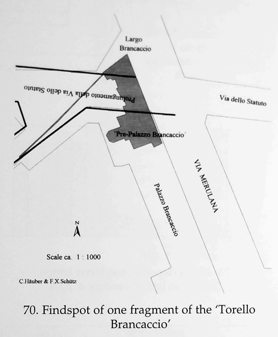
Figure 70 shows the findspot of one fragment of the `Torello Brancaccio´, a statue of an Apis bull made of a rare black stone. Rome, Palazzo Altemps (inv. no. 182594). It was found `under the Palazzo Brancaccio´, or else "presso Via dello Statuto in suolo annesso al palazzo Brancaccio" (NSc 1886, 50, 121; BullCom 14, 1886, 208; Lanciani 1888; Häuber 1990, 48 n. 109). Today it seems difficult to judge, whether the latter note was correct or not, because the Palazzo Brancaccio and the road Via dello Statuto are divided by the modern road of the Via Merulana, which was built in the year 1575. Figure 70 consists of two digitized and geo-referenced layers, using an aerial photograph (1: 1000), taken on June 11th, 1990 (Atlante, pls. 128; 129), and a detail of a land survey, owned by the family of the painter Francesco Gai (1: 500; ca. 1874; cf. Häuber 1990, 12, 41-42, n. 88, fig. 24), which shows the landsurvey of 1866 (Häuber 1990, fig. 34.1), with the predecessor of the Palazzo Brancaccio (= `Pre-Palazzo Brancaccio´), as well as the future Largo Brancaccio. The `Pre-Palazzo Brancaccio´ was destroyed in order to build the Palazzo Brancaccio, and the multiple junction between the square Largo Brancaccio and two roads (today: Via Giovanni Lanza), the latter is labelled on this land survey: "prolungamento della Via dello Statuto". We intersected both layers. The result suggests that the fragment of the `Torello Brancaccio´ was found somewhere between Palazzo Brancaccio and the then western part of the Via dello Statuto (today: Largo Brancaccio).
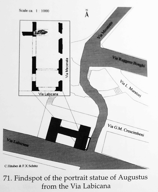
Figure 71 shows the findspot of the portrait statue of Augustus from the Via Labicana (Rome, Museo Nazionale Romano, Paazzo Massimo inv. no. 56230). The statue was found in a foundation wall of a modern building. A plan was published by A. Pasqui (NSc 1910, 223-228, esp. 224, fig. 1), see the inserted box on figure 71, top left. According to Pasqui's plan the building stood at the junction of the modern roads of the Via Labicana and the Via Mecenate; notice that both roads form in plan a right angle. Lanciani's Forma Urbis Romae (fol. 30) does not show a junction of the Via Mecenate (at his time: Leopardi) and the Via Labicana, nor does it exist today. An aerial photograph, taken on February 11th, 1919 (Atlante, fig. 24), which shows the junction of the Via Mecenate and the Via Labicana, solves the problem. Figure 71 was made by intersecting two digitized and geo-referenced layers: using the aerial photograph taken in 1919 (ca. 1: 10 000) and the aerial photograph taken in 1990 (1: 1000; Atlante, pl. 167). In addition to this we inserted Pasqui's plan of the findspot (1: 500; NSc 1910, 224, fig. 1). We are fully aware of the fact, that the intersection of plans which differ in scale from 1: 1000 to 1: 10 000 cannot result in a very precise plan. But if we had not already known that the statue of Augustus was found while constructing a building, which is today the Albergo Delta on the Via Labicana (de Vos 1993, 88), our figure 71 would have shown us.
References
K.M.S. Allen - St.W. Green - E.B.W. Zubrow (eds.) 1990: Interpreting Space: GIS and archaeology, London, New York, Philadelphia
Comune di Roma (ed.) 1996: Atlante di Roma. La forma del centro storico in scala 1: 1000 nel fotopiano e nella carta numerica4, Venezia
A.P. Frutaz 1962: Le Piante di Roma I-III, Roma 1962
A. Jaeschke et al. 1992: Metawissen als Teil von Umweltinformationssystemen, 115, in O. Günther et al. (eds.), Konzeption und Einsatz von Umweltinformationssystemen, Proceedings, Berlin (= Informatik Fachberichte 301)
W.F. Jashemski 1979, 1993: The Gardens of Pompeii Herculaneum and the Villas destroyed by Vesuvius I.II, New Rochelle, NY
K.L. Kvamme, A view from across the water: the North American experience in archaeological GIS, in Lock - Stančič 1995, 1-14; R. Lanciani 1893-1901: Forma Urbis Romae, Milano
G. Lock - Z. Stančič (eds.) 1995: Archaeology and Geographical Information Systems: A European Perspective
Open GIS Consortium: URL <http://www.opengis.org/info/brochure/brochure_2.htm> (last visit 22-IX-1998)
R.F. Tomlinson 1976: The Canada Geographic Information System (CGIS), in UNESCO, Natural resources research XIII, Paris, 27-73;
References concerning FORTVNA:
C. Häuber - F.X. Schütz 1997: FORTVNA: Ein multimediales Geographisch-Archäologisches Informationssystem GIS[A], in F. Dollinger - J. Strobl (eds.), Angewandte Geographische Informationsverarbeitung, Salzburger Geographische Materialien 26, 263-268;
eadem 1997: FORTVNA. Ein multimediales Geographisch-Archäologisches Informationssystem GIS[A]. Erste Anwendungsbeispiele, in Gesellschaft zur Förderung angewandter Informatik e.V. Berlin - VASARI ENTERPRISES Aldershot (eds.), EVA ´97 Berlin. Konferenzband. Elektronische Bildverarbeitung & Kunst, Kultur, Historie, Berlin, paper no. 10.
References concerning our test area:
F.A. Bauer 1997: Einige weniger bekannte Platzanlagen im spätantiken Rom, in Pratum Romanum, Richard Krautheimer zum 100. Geburtstag, Wiesbaden, 27-54, esp. 37-41
A.L. Cubberley (ed.) 1988: Notes from Rome by Rodolfo Lanciani, British School at Rome, 205-207 (= The Athenaeum vol. 3191, 855, December 22nd, 1888)
S. Ensoli 1997: in Exhibition-catalogue Iside. Il mito il mistero la magia, Milano, 306-321, esp. 309, 320
F. Guidobaldi 1996: Domus: Petronius Maximus, in LTUR II
C. Häuber 1990: Zur Topographie der Horti Maecenatis und der Horti Lamiani auf dem Esquilin in Rom, KJ 23, 11-107; id. 1996: Horti Maecenatis, in LTUR III; id. 1998: "Art as a weapon". Von Scipio Africanus maior bis Lucullus, domus, horti und Heiligtümer auf dem Esquilin, in M. Cima - E. La Rocca, Horti Romani, 6. Suppl. BullCom, 83-112
C. Lega 1995: Forum Petronii Maximi, in LTUR II
S. Panciera 1996: Il precettore di Valentiniano III, in Studi in onore di Albino Garzetti, Brescia, 277-297, esp. 284, 296
L. Richardson 1993, A new Topographical Dictionary of Ancient Rome, Baltimore-London, s.v. domus: Petronius Maximus; forum Petronii Maximi
M. de Vos 1993: Il tempio di Iside in Via Labicana a Roma, in A. Mastrocinque (ed.), I Grandi Santuari della Grecia e L'Occidente, Trento, 81-91; id. 1994: Aegyptiaca Romana, PP 49, 130-159; id. 1996: Iseum Metellinum (Reg. III), in LTUR III.
Figs. 70 and 71 in separate Volume "Plates"
Datenschutzerklärung | Impressum