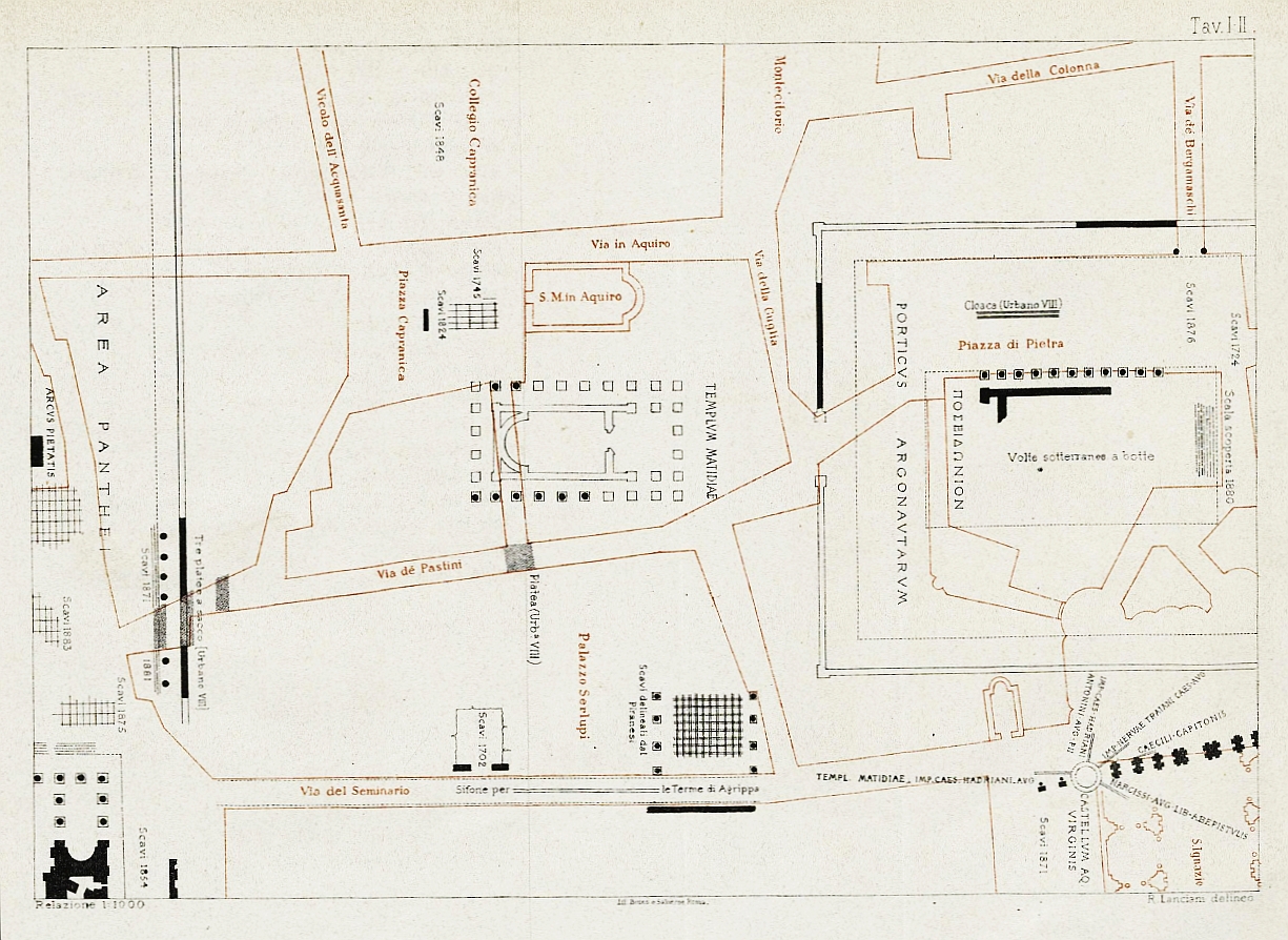
Fig. 66.4. R. Lanciani's plan (1883a, Tav. I-II) and the sheet of his map FUR (1893-1901, fol. 15), which document the here-so-called `Lanciani's porticus´. This plan and his map, created by Lanciani, belong to his discussion (1881, 270; 1883a, 15) of a porticus, excavated and documented by him in 1871, 1879 and 1881 `at the junction of the square in front of the Pantheon with the Via dei Pastini´, or, when we look at his plan and his map: this porticus stood immediately to the north-west and to the south of the junction of the roads Via dei Pastini and Via degli Orfani (cf. here Fig. 66). Whereas Lanciani himself (erroneously) attributed this porticus to an (alleged) colonnaded forecourt of the Pantheon, his porticus stood in reality within the area of the Precinct of Diva Matidia.
Lanciani (1881; 1883a, Tav. I-II; FUR, fol 15) excavated his porticus, which he (erroneously) attributed to the (alleged) colonnaded forecourt of the Pantheon, in reality within the area of Beste's and von Hesberg's Precinct of Diva Matidia (cf. here Fig. 64). `Lanciani's porticus´ was oriented to the west (!) (cf. here Fig. 66.4). Its existence precludes Beste's and von Hesberg's entire reconstructions of their Precinct and Temple of Diva Matidia. The reason being that Beste and von Hesberg (2015, 242, Fig. 28; Tav. II, K; cf. here Fig. 64) assume within their reconstructions of the Precinct and Temple of Diva Matidia the western branch of their "portico su tre lati", which is oriented to the east (!), at exactly the same site, where `Lanciani's porticus´ actually stood.
The reason for Lanciani's relevant error was the fact that he himself had not realized that the cadastre, on which he had based his plan of 1883a, as well as his map FUR (both here Fig. 66.4), contained an error in this area. Because of this error, `Lanciani's porticus´ appears on his own plan and map circa 13 m to the west of its true location. This fact, in its turn, had the effect that on Lanciani's plan and map (here Fig. 66.4) `Lanciani's porticus´ actually seems to be located immediately to the north-east of the Pantheon (!). Lanciani's relevant error concerning his porticus, that had allegedly belonged to a (never existing) colonnaded forecourt of the Pantheon, has been followed by almost all subsequent scholars.