
Mit neuer Lokalisierung der Porta Capena, mit der Quelle und dem heiligen Hain der Nymphen Camenae (fons et lucus Camenarum), sowie Diskussion des Scipionengrabes (sepulcrum [Corneliorum] Scipionum)
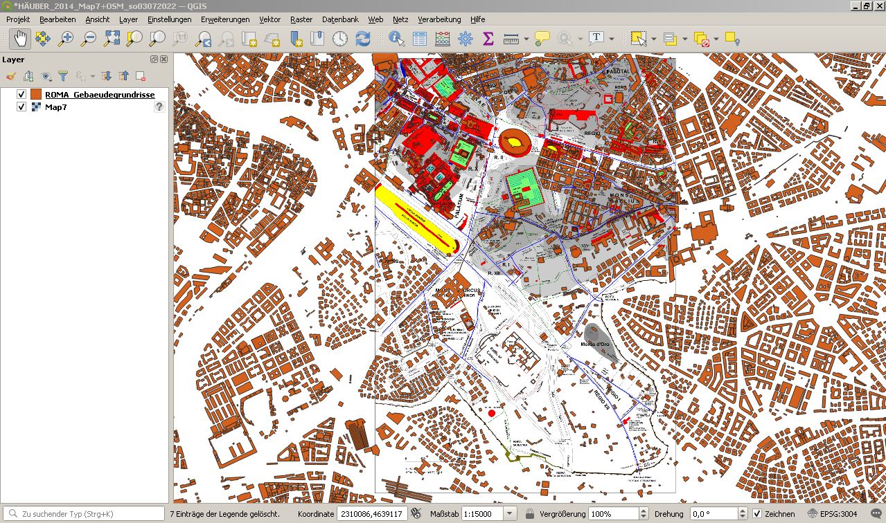
Romkarte. Die antike Via Appia zwischen der Porta Capena in der sogenannten Servianischen Stadtmauer und der Porta Appia/ Porta S. Sebastiano in der Aurelianischen Stadtmauer.
Mit neuer Lokalisierung der Porta Capena, mit der Quelle und dem heiligen Hain der Nymphen Camenae (fons et lucus Camenarum), sowie Diskussion des Scipionengrabes (sepulcrum [Corneliorum] Scipionum)
Es handelt sich um die von Chrystina Häuber (2014) publizierte Karte:
Map 7: The area between the Porta Capena and the Porta Appia/ Porta S. Sebastiano.
Vergleiche für eine Karte mit allen Stadtmauern Roms hier Karte mit allen Stadtmauern Roms
Im Text, der diese Karte erläutert, wird unter anderem die neue Rekonstruktion der sogenannten Servianischen Stadtmauer auf der Ostseite der Stadt Rom zwischen der Porta Esquilina bis zur Porta Capena vorgestellt, die Chrystina Häuber, The Eastern Part of the Mons Oppius ..., 22. Suppl. Bull Com (2014) vorgeschlagen hat. Mehrere Wissenschaftler sind diesem Vorschlag gefolgt: Eric M. Moormann (2015), James C. Anderson (2016), Mario Torelli (2016), Pierre Gros (2016) und T.P. Wiseman (2021).
Siehe auch die Karte, die im Buch von Chrystina Häuber (2014) `Map 3´, heißt. Diese Karte schließt an die hier diskutierte Karte `Map 7´ im Norden an und wird im folgenden Text häufig zitiert.
Siehe hier: Map3 aus HÄUBER 2014Im folgenden Text, der zu der hier publizerten Karte `Map 7´ gehört, wird ausführlich die neue Lokalisierung der Porta Capena innerhalb der Servianischen Stadtmauer begründet, die Chrystina Häuber (2014) vorgeschlagen hat.
Gleichzeitig, aber unabhängig von Chrystina Häuber, hat sich auch Ronald T. Ridley mit der Lokalisierung der Porta Capena beschäftigt. Ridley stützt sich dabei auf ein ganz anderes Methodenspektrum und ganz andere Daten als Häuber (2014), gelangt jedoch, was seinen Vorschlag der korrekten Lokalisierung der Porta Capena betrifft, zu genau demselben Ergebnis wie sie.
Vergleiche Ronald T. Ridley, "The `discoveries´ of the Porta Capena", RendPontAcc 88 (2015-2016) S. 567-585.
Die hier abgedruckten Texte wurden im Buch von Chrystina Häuber (2014) veröffentlicht, zusammen mit der hier gezeigten Karte, die in diesem Text als `Map 7´ bezeichnet wird.
Die folgenden Texte bestehen aus:
- der Legende zur `Map 7´ (2014)
- und dem Text, in dem die topographischen Details der `Map 7´ erläutert werden.
Für die Bibliographie zum Buch von Chrystina Häuber (2014), vergleiche:
Bibliography aus HÄUBER 2014
Legende zur hier veröffentlichten `Map 7´; vergleiche Chrystina Häuber (2014, S. 873):
"EXPLANATIONS FOR OUR MAPS
Introductory remarks
Our maps published here are based on the photogrammetric data (scale 1: 500) of the Sovraintendenza ai Beni Culturali (BB.CC.) of the Comune di Roma (now: Roma Capitale), which were generously provided by this institution. These data were generated for the ``Centro di Documentazione Forma Romae´´, and are the basis of the project ``Nuova Forma Urbis Romae´´; cf. the chapter Acknowledgements and Introduction. The maps were drawn with the Archaeological Information System ``AIS ROMA´´. This information system is based on the object-oriented software ``FORTVNA´´, into which functionalities of 3/4D-GIS are incorporated. This and the ``AIS ROMA´´ Franz Xaver Schütz and I developed for the purpose ourselves. We are both cooperation partners of the project ``Nuova Forma Urbis Romae´´. The cartographic data of these maps were thus integrated by using GIS-technology. The applied methodology allowed also the integration of cartographic information from Giambattista (G.B.) Nolli’s Rome map (1748; cf. map 1)".
Vergleiche Chrystina Häuber (2014, S. 875):
"Map 7: The area between the Porta Capena and the Porta Appia/ Porta S. Sebastiano.
Only topographical features, which can be certainly located are integrated into this map. Red areas represent ground-plans of ancient buildings, including in some cases churches. Pink areas adjacent to them, and bordered with dotted lines are reconstructed parts of those buildings. Grey areas within the ground-plans of ancient buildings are open air spaces. The adjacent light grey areas, bordered by dotted lines, are reconstructed parts of these open air spaces. The sizes and shapes of the red areas do not represent in all cases the original sizes and shapes of the ground-plans of the ancient structures and buildings in question, because many of these were already heavily destroyed when found or documented, or had occurred in building sites, where it was impossible to document them in their entirety. Excavated sections of the Servian city Wall are drawn as 4 m wide light brown lines, the reconstructed course of the Servian city Wall as 4 m wide dark brown lines. The Aurelianic Walls appear in a different brown shade. Their ground-plan was drawn after the photogrammetric data. Ancient roads are drawn as 3 m wide dark blue lines, and post-antique roads, copied after G.B. Nolli's Rome map (1748; cf. map 1), as light blue lines, reconstructed ancient roads as dotted green lines, cisterns and water basins as blue areas, and gardens as green areas. Raised areas, by which the plateaus of hills were enlarged, are indicated with a light grey area bordered by a dotted line. The shaded relief was drawn after G.B. Nolli’s Rome map (1748); following recent studies, the relevant cartographic information was at some points corrected.
This map was made with the ``AIS ROMA´´ and is based on the photogrammetric data of the Comune di Roma (now: Roma Capitale). C. Häuber & F.X. Schütz, actual state September 13th, 2013, reconstruction. The photogrammetric data were generously provided by the Sovraintendenza ai Beni Culturali (BB.CC.) of the Comune di Roma (now: Roma Capitale) These data were generated for the ``Centro di Documentazione Forma Romae´´, and are the basis of the project ``Nuova Forma Urbis Romae´´; cf. chapter Acknowledgements and Introduction, of which C. Häuber and F.X. Schütz are cooperation partners".
Der folgende Text ist (verändert) aus Chrystina Häuber (2014, S. 274-289) übernommen.
"Appendix I The Reconstruction of the Servian city Wall on the Oppian and Caelian
...
The Servian wall between the Arcus Dolabellae et Silani and the Porta Capena [n. 223]
Nicholas Purcell [n. 224] has drawn a vivid picture of the area outside the Porta Capena of the Servian city wall, which was the starting point of the ancient Via Appia [n. 225], and Laura Asor Rosa [n. 226] dedicated recently an excellent topographical study to it, including a survey of extant architectural finds. She can for example precisely locate the fragment of the Severan marble plan which represents the Mutatorium Caesaris [n. 227] outside the Porta Capena, where emperors changed from military to civilian garb on returning from campaign; hitherto it was assumed to be further [page 275] down the Via Appia to the south-east [n. 228]. Because the Area Radicaria [n. 229] is also visible on the same fragment of the Severan marble plan, Asor Rosa can likewise locate that building, the ``uffici del dazio di porta Capena´´ [n. 230]. I have integrated Asor Rosa's findings into our map (maps 3; 7, labels: site of MUTATORIUM CAESARIS; site of AREA RADICARIA). The relevant fragment of the Severan marble plan shows a section of the ancient Via Appia, and because it includes the letterings (m)VTATORIVM (caesaris) (which the ‘Constantinian’ regionary catalogues list for Regio I) on the north-east side of the Via Appia, and AREARADICARIA (i.e. area radicaria, which the ‘Constantinian’ regionary catalogues list for Regio XII) on its south-west side [n. 231], it is evident that the Via Appia divided those two Regiones (maps 3; 7, labels: R. I; R. XII).
The precise location of the Mutatorium Caesaris is also important in so far as Emilio Rodríguez Almeida convincingly suggests that another service area outside the Porta Capena was probably related to it, the Area Carruces, listed by the ‘Constantinian’ regionary catalogues in Regio I [n. 232]. Here service men called carrucarii loaded and unloaded the leaving and incoming carriages - private carriages were not allowed to circulate in the City of Rome. We know from Juvenal (3.316-318) that the Area Carruces was within ear-shot, as well as visible, from the near by lucus Camenarum [n. 233]. So far it is impossible to locate the Area Carruces. This is also true for the Senaculum [n. 234], which likewise stood in this area (outside the pomerium), one of the three buildings of that name, where the senate met with the magistrates cum imperio and with foreign ambassadors.
Because of the existence of the studies just mentioned, the following remarks are concentrated only on the topographical features shown on our map [= map 7]. Especially important for my own work is the fact that Asor Rosa has introduced a new crossroad of the Via Appia, visible on the Severan marble plan, which led in south- west north-east direction from the ancient Via Appia to the Mutatorium Caesaris. She rightly observes that this road was still visible on Nolli's map (cf. here map 1) [n. 235], and that Antonio Maria Colini had identified it with the Vicus Camenarum [n. 236]. Because I ‘moved’ the Porta Capena from its hitherto assumed position to the north-west, all my identifications of the crossroads of the ancient Via Appia (to be discussed below) are hypothetical. In our maps, I have tentatively identified the road leading to the Mutatorium Caesaris with the Vicus Drusianus (map 3 [; 7], label: VICUS DRUSIANUS?), of which we know that it was located between the Vicus Camenarum and the Vicus Sulpicius ulterioris [n. 237].
Colini was first to locate the Porta Caelimontana of the Servian city wall at the site of the Arcus Dolabellae et Silani (map 3 [; 7], labels: Servian city Wall; PORTA CAELIMONTANA?/ARCUS DOLABELLAE ET SILANI), and he located the Porta Capena of the Servian wall at the point, where in 1867-1868 John Henry Parker had ‘excavated’ ancient structures which in his opinion [page 276] belonged to the Porta Capena and to the Aqua Appia; this is still the prevailing view [n. 238]. In addition, Colini identified (in my opinion correctly) the Piazza di S. Giovanni in Laterano with the Campus Caelemontanus [n. 239], and suggested also that ‘Campus Caelemontanus’ and ‘Campus Martialis’ were synonyms [n. 240]. Like Säflund [n. 241], but based on different evidence, I locate the Porta Caelimontana on the ‘Via Tusculana’/Via dei Santi Quattro Coronati, north of the point of its junction with the ‘Via Caelimontana’/Via di S. Stefano Rotondo. That the Porta Caelimontana stood here and not, as Colini believed, near the Arcus Dolabellae et Silani, is proved by the toponym of the former Cappella di S. Gregorio in Martio [n. 242] (map 3, label: site of S. Gregorio in Martio), because that refers to the Campus Martialis [n. 243] (i.e. the Campus Caelemontanus = Piazza di S. Giovanni in Laterano; cf. map 3, labels: CAMPUS CAELEMONTANUS (MARTIALIS); Piazza S. Giovanni in Laterano). The Cappella di S. Gregorio in Martio stood on the south-east side of the former Via della Ferratella (today: Via dell'Amba Aradam) [n. 244], close to the junction of that road with the Piazza di S. Giovanni in Laterano, and immediately west of the Baptistery of S. Giovanni in Laterano (map 3, labels: Piazza S. Giovanni in Laterano; S. Giovanni in Laterano; Baptistery; Via dell' Amba Aradam (former Via della Ferratella)). Colini’s location of the Porta Caelimontana at the site of the Arcus Dolabellae et Silani is nevertheless the prevailing view. That Via dell'Amba Aradam replaces the former Via Ferratella is shown by a comparison with Nolli's map (1748; map 1, index no. 2: Strada della Ferratella) [n. 245] and a remark by Colini [n. 246] (the extension of Via dell'Amba Aradam to the south-west is called Via Druso, map 7 [n. 247]). Note that there is currently another road called ‘Via della Ferratella’ [n. 248], which runs south of the former one, and parallel to the Aurelianic Walls on its north side (map 3, label: Via della Ferratella).
[page 277]
If the Piazza di S. Giovanni in Laterano was indeed the Campus Caelemontanus, then the Porta Caelimontana also stood near-by because the gates and squares, sharing common names, obviously served common functions, and were therefore immediately adjacent: Campus Caelemontanus and Porta Caelimontana [n. 249], Campus Esquilinus and Porta Esquilina [n. 250] (cf. map 3), Campus and Porta Viminalis [n. 251], with the further characteristic, that all these campi lay immediately outside the Servian city wall [n. 252]. These spaces were multifunctional. As already mentioned, in the case of the Porta Capena the Area Carruces is recorded for Regio I, and assumed to be outside the gate where the carrucarii loaded and unloaded the raedae (carriages) leaving and arriving [n. 253].
Since we also integrated the orography of Nolli’s map into our map (map 3 [; 7]), updated with the reconstruction of the orography of the Caelian (especially on its southern side) by Colini [n. 254], which was based on his own excavations, it is obvious that ‘in front of’ (i.e. outside) the Arcus Dolabellae et Silani there is not enough space for the Campus Martialis [n. 255]. We know from literary sources that, whenever the regular festival of the Equirria [n. 256] in honour of Mars was made impossible because the Campus Martius was under water, it was celebrated at the Campus Martialis on the Caelian instead [n. 257].
Colini assumed the Porta Capena to be where Parker believed he had found remains of the Porta Capena and of the Aqua Appia - the course of which passed close by this city gate, as we know from literary sources. Säflund [n. 258] and Lanciani also followed Parker’s suggestion (FUR, fol. 35; map 2, labels: MVRUS SERVII; P.A CAPENA; Scavi Parker 1866-1867), and Pavolini follows Colini [n. 259].
Recently Antonio Mucci [n. 260] has observed that the architectural remains found by Parker cannot be identified with the Aqua Appia (built in 312 BC), which means in my opinion that the Porta Capena may not be located near this site either. Mucci’s new finding is important, since in the literary sources many topographical features are described in relation to the Porta Capena – thus this whole ‘cluster’ of toponyms has lost its centre.
[page 278]
Mucci himself mentions this finding only in passing, but he is clearly right, since the aqueducts ‘excavated’ by Parker (and by others at the same site) date to later periods [n. 261]. Besides, the channel of the Aqua Appia, almost entirely subterranean, near the Porta Capena was carried on substructions and arches for a section of 60 paces (c.[irca] 89 m) in length [n. 262], which has led Lawrence Richardson jr. to assume that the aqueduct crossed the valley between Caelian and Aventine on arches [n. 263]. In addition to this we hear that the Rivus Herculaneus, a branch of the Aqua Marcia (built 144- 140/139 BC) [n. 264], crossed above the Porta Capena, which was hence described as dripping (madida), and has been identified with the Arcus Stillans, recorded by literary sources [n. 265]. Parker’s finds, and later ones at the same site, do not fit these ancient descriptions [n. 266]. The fact that the Arcus Stillans is described as ante Septem Solium (i.e. the Septizonium) in the Mirabilia [n. 267] seems to fit my location of the Porta Capena better than the traditional one (cf. here map 7, labels: PALATIUM; Septizonium; PORTA CAPENA; Via Appia).
The topology [n. 268] (sequence) of the cross- roads of the Via Appia outside the Porta Capena is known: Vicus Honoris et Virtutis, Vicus Camenarum, Vicus Drusianus, Vicus Sulpicius ulterioris, Vicus Sulpicius citerioris [n. 269]. For the location of the Vicus trium Ararum a consensus has been established, which is not yet true in the case of the Vicus Fortunae Obsequentis and of the Vicus Pulverarius, likewise recorded for Regio I (cf. infra; here maps 3; 7) [n. 270]. Our integration of Colini’s reconstructed orography shows that his location of the ‘valley of the Nymph Egeria’ (Vallis Egeriae) is convincing. Besides, there was only one valley in the south-west slope of the Caelian, and it is conceivable that my Porta Capena was visible from there [n. 271] (and people working in the vicinity of my Porta Capena would be audible at the Vallis Egeriae), as described by the literary sources on the Vallis Egeriae. They mention in addition to this that people who came from the Porta Capena went ‘down’ to the Vallis Egeriae, and that it comprised the shrine, a meadow, and the fons et lucus Camenarum [n. 272]; ‘fons Camenarum’ and ‘fons Egeriae’ were obviously synonyms [n. 273], and we hear that this fons was in a grotto [n. 274]. The lucus Camenarum was outside the Porta Capena, and [page 279] close to the gate, as Emilio Rodríguez Almeida [n. 275] rightly deduces from Juvenal (3.10-20) (map 3 [; 7], label: VALLIS EGERIAE). The lucus Camenarum had further importance, as Filippo Coarelli has observed, because it ``appartenait .. à la petite couronne des luci di confin´´, like the lucus Furrinae, and as I suggest, the lucus of the Mons Oppius/of the Querquetulanae Virae [n. 276] (cf. map 3 and separate box; maps 9; 10).
I follow grosso modo the sequence of Colini’s topographical features in this area, who mapped it only as far south as his Vicus Drusianus, with the great difference that my Porta Capena, and consequently all the other topographical features, are to be found more to the north-west. Note that I tentatively identify on our maps Colini’s Vicus Drusianus with the Vicus Sulpicius citerioris (map 3, [; 7], label: VICUS SULPICIUS citerioris?). The area studied by Colini thus includes the ancient building located to the north-east of the ancient Via Appia, which accommodates the church of S. Maria in Tempulo (maps 3; 7, label: S. Maria in Tempulo). Originally this had been an oratorium, called ‘S. Agatha in monasterio Tempuli’; its first building phase is datable to the 6th century AD [n. 277].
Rodolfo Lanciani located the Vallis Egeriae in an area south-east of the one just mentioned, north-east of the ancient Via Appia, south-east of my Vicus Sulpicius citerioris, north-west of the current Via Druso and south-west of Via della Navicella (FUR, fol. 36; map 2, label: VALLIS EGERIAE; maps 3; 7). We may wonder whether from Lanciani’s Vallis Egeriae, which is not exactly close to his own Porta Capena, this was visible, and people working there, audible at all. Note that the valley found by Colini on the western slope of the Caelian and shown in his reconstruction of the ancient landscape, which we incorporated into our map (map 3 [; 7], label: VALLIS EGERIAE), was not visible at Lanciani’s time. If it had been, he himself would probably have located the Vallis Egeriae there. The photogrammetric data show a lineament, which is also a ‘persistent’ line [n. 278], between the Arcus Dolabellae et Silani and the ancient Via Appia, running in an almost straight line from the north-east to the south-west (cf. infra). On its north-west side stood an ancient building in Nolli’s time, which is partly extant and also visible in the photogrammetric data; we copied its ground-plan after Nolli’s map (map 1). It was described by Parker and Colini and appears also in the FUR, fol. 35 (map 2): to the north-west of this building we read in the FUR: ``AED. HON. ET VIRTVTI Grandiosi avanzi di un tempio? (Fea)´´ [n. 279]. The building itself is labelled ``FONS MERCURII? Lanciani Acq. p. 10 [n. 280], Scavi Parker; FONTES ET NYMPHAE CIL, 166´´. Asor Rosa calls this building ``un complesso di muri in opera reticolata e laterizia nel Parco di S. Gegorio´´, which ``resta in piedi, in precario stato di conservazione´´ [n. 281].
The spring of the Camenae [n. 282] was located in a lucus through which the Vicus Camenarum [page 280] passed [n. 283]; this was a crossroad of the ancient Via Appia. Among the Nymphs venerated at Rome, the Camenae had special importance and Egeria was counted among them. Giovanni Colonna quotes a remark by Festus, according to which ``alle Camene, chiamate Camelae virgines … supplicare nupturae solitae erant´´ [n. 284], also the Vestals, the ``perpetuae nubendae´´ [n. 285] drew their daily water from the spring of the Camenae. C. Robert Phillips suggests that the name of the ``water goddess`` Egeria derives perhaps from egerere, `to deliver´; pregnant women sacrificed to her for easy delivery [n. 286]. ...
I suggest that the `persistent´ line mentioned above should be identified with the ancient Vicus Camenarum, passing through the lucus Camenarum, and that the ancient building documented in plan by Nolli and Asor Rosa is the ruin of their fons, or another building belonging to the temple of the Camenae in the lucus Camenarum (maps 3; 7, labels: VICUS CAMENARUM?; site of FONS ET LUCUS CAMENARUM?). I assume some other buildings here, since already in Horace's day and later the collegium poetarum met in this grove [n. 292]; according to ancient belief, drinking the water of a spring sacred to the Nymphs could stimulate poetic inspiration [n. 293].
It has also been suggested that the collegium poetarum met in the temple of Hercules and the Muses in the Circus Flaminius [n. 294], and Nicholas [page 281] Purcell believes that from the second half of the 1st century BC ``the aedes Herculis Musarum and the porticus surrounding it had become something of a centre for poets rather after the general model of the Museum at Alexandria´´ [n. 295] ...
[page 282]
In my reconstruction, the Vicus and the lucus Camenarum are located within my Vallis Egeriae (map 3 [; 7], labels: VICUS CAMENARUM?; site of FONS ET LUCUS CAMENARUM?; VALLIS EGERIAE). In theory, the collegium poetarum could also have met in the temple proper (aedes) [n. 320] of the Camenae, which is only once mentioned by Pliny (Nat. Hist. 34, 19); but where was it?
[page 283]
On Nolli’s map (map 1) the ancient building, here identified with a structure in the lucus Camenarum, stood in the ``Vig.(na) de Monaci Camaldolesi in S. Gregorio´´, on the north side of a wall, which divided this property from Villa Mattei (map 3 [; 7], labels: Villa Mattei/Celimontana; Casino Villa Mattei/Celimontana). In 1817-1819 Carlo Fea [n. 321] `excavated´ a spring in the Vigna of the monks of S. Gregorio, which he took for the Aqua Mercurii [n. 322], and immediately above it ``i grandiosi avanzi di un tempio, la costruzione del quale attribuì a Marco Aurelio´´, as reported by Asor Rosa [n. 323]. Antonio Nibby described those finds as ``un antico nobile fabbricato di costruzione laterizia e reticolata dei tempi migliori [n. 324] … in cui sgorgava un'acqua limpidissima´´, which he too identified with the Aqua Mercurii - but this was a spring for which no shrine is recorded [n. 325]. Lanciani was unable to say where Fea's finds had occurred [n. 326], but see his tentative location and identification of these finds as the temple of Honos and Virtus (FUR, fol. 35; map 2; cf. supra). In the course of past centuries, many springs were `excavated´ on the south and south-west slopes of the Caelian [n. 327], but none with a temple. If we follow Colini's and my location of the Vallis Egeriae, and consider that Fea found a spring next to a temple, which stood in exactly that Vigna where we might duly expect them to appear, it follows that Fea had found the fons and temple of the Camenae. The fons Camenarum was regarded as one of the ``fonti medicinali´´ [n. 328] and ``sorgenti sacre´´ of Rome and was ``celebrato per la purezza delle acque´´ [n. 329].
As already mentioned above, Lanciani had tentatively identified (cf. FUR, fol. 35; map 2) the ancient building, here assumed to have belonged to the fons et lucus Camenarum (map 3 [; 7], labels: VICUS CAMENARUM?; site of FONS ET LUCUS CAMENARUM?), with the fons Mercurii, and the lettering on the FUR at this site reads: ``FONTES ET NYMPHAE CIL, 166´´. This inscription (CIL, VI, 166; fig. 147) appears on a Roman marble relief in the Musei Capitolini, Palazzo Nuovo; cf. B 35. ...
[page 284]
Some scholars believe that the Regio I extended south-west over the ancient Via Appia [n. 335]; according to them the Vicus Sulpicius pre-dated the ancient Via Appia, was divided by it, and its resulting parts were henceforth called Vicus Sulpicius ulterioris and citerioris. I follow Lanciani [n. 336], Domenico Palombi [n. 337] and Claudia Lega [n. 338], who rightly believe that the Regio I was bounded to the south-west by the ancient Via Appia (cf. supra), and that the names Vicus Sulpicius ulterioris and citerioris refer to two different roads, located in the north-west south-east sequence shown here (map 3 [; 7], labels: R. I; VICUS SULPICIUS ulterioris?; VICUS SULPICIUS citerioris?). Lega identifies the Vicus Sulpicius with Via Druso [n. 339].
The temple of Fortuna Obsequens [n. 340] stood on the Vicus Fortunae Obsequentis, another crossroad of the Via Appia, located between the Vicus Sulpicius citerioris and the Vicus Pulverarius [n. 341]. Lega [n. 342] assumes that the temple of Fortuna Obsequens was at the point where the Via Appia and the Via Latina divided, therefore it faced on modern Via Druso, Lega's Vicus Sulpicius. But because the temple of Fortuna Obsequens stood on the Vicus Fortunae Obsequentis, I tentatively identify Via Druso with that Vicus. Note that my identification of Via Druso with the Vicus Fortunae Obsequentis is only possible because I ‘moved’ the Porta Capena to the north-west (map 3 [; 7], labels: VICUS FORTUNAE OBSEQUENTIS?; Via Druso; S. Sisto Vecchio; site of AEDES: FORTUNA OBSEQUENS?).
Because Lanciani followed Parker’s location of the Porta Capena, he also followed his location of the fons et lucus Camenarum at a site south-east of the one suggested here [n. 343]. The structure in question had already been characterized as ancient by Nolli; it stood in his time in the Vigna of the Monache di S. Lorenzo in Panisperna and was used as their Casino (map 1: label: Vign.[a] delle Monache di S. Lorenzo in Panep.a). Today this ancient building is located within the Semenzaio Comunale and one part of it accommodates the Ufficio Tecnico del Servizio Giardini del Comune di Roma [n. 344]. Lanciani [n. 345] identified it with the ‘Fonte Lolliano’ [n. 346], a Nymphaeum found in 1558 and documented by Pirro Ligorio in plan and elevation [n. 347] (cf. FUR, fol. 35; map 2, labels: Locus NYMPHAEI a Ligor. Taur. xv delineate?? Nolli n. 1994-1995 (De Rossi [n. 348]) FONS CAMENARUM CIL, VI 155 - 165) [n. 349].
[page 285]
Asor Rosa [n. 350] observes that the function of this ancient building cannot be determined, and that it is impossible to identify it either with the Nymphaeum drawn by Ligorio or with the fons et lucus Camenarum (maps 3; 7, label: Casino delle Monache di S. Lorenzo in Panisperna/unidentified building Nolli/Parker). Directly to the south of this ancient building, the following finds are documented in the FUR (fol. 35; map 2, label: Orto del Carciofolo [n. 351] delle Monache di Panisperna già Belardi 1670); and on the north-east side of the ancient Via Appia: ``Grandi scavi 1670-71 >Molte stufe< Bartoli m.[emoria] 13 Mosaici CIL. VI. 10203´´. Two wall mosaics with gladiatorial fights were found here, which Cardinal Camillo Massimo [n. 352] bought for his collection of ancient paintings and mosaics [n. 353]; cf. B 1. According to Lucilla de Lachenal, these mosaics were found ``nel 1670 nell'orto di proprietà delle monache di S. Lorenzo in Panisperna, alle pendici del Celio verso Porta Capena e la cd. [cosiddetta] valle delle Camene, in località detta >il Carciofolo<´´, in a room equipped with numerous fistulae aquariae and defined ``bagnio´´ or ``natatorio´´ by its `excavators´.
Some scholars [n. 354] identify these finds with the bath building of some rich domus [n. 355], and the Thermae Severianae, recorded for Regio I, have also been located at this site [n. 356]. So also by Susann S. Lusnia [n. 357]. The Thermae Severianae et Commodianae are listed in the ‘Constantinian’ regionary catalogues for Regio I [n. 358]. Since Regio I was bounded to the south-west by the ancient Via Appia (map 3 [; 7], label: R. I), I do not follow the identification of the Thermae Severianae [n. 359] with the ancient building underneath the church of S. Cesareo de Appia [n. 360], located on the south-west side of the Via Appia, where a large black- and-white mosaic with marine scenes, typical for bath buildings, was found (this area belonged to Regio XII). I tentatively locate at this site the shrine or temple of Isis Athenodoria, recorded for Regio XII (map 7, labels: R. XII; S. Cesareo de Appia/Building 2. century AD/site of ISIS ATHENODORIA?).
My hypotheses concerning the crossroads of the ancient Via Appia seem to be further supported by two facts, firstly the location of the Horti of Drusus Caesar (which lay ``subito fuori porta Capena´´ [n. 361]) near my Vicus Drusianus, and secondly the fact that between my Vicus Camenarum and my location of Porta Capena there is an- [page 286] other lineament visible in the photogrammetric data. It leads down from the south-western slope of the Caelian, ends on the north-east side of the ancient Via Appia, and was interpreted by Colini as a `persistent´ line, `recording´ the former course of the Servian city wall [n. 362]. I tentatively identify this `line´ with the crossroad of the ancient Via Appia called Vicus Honoris et Virtutis [n. 363] (map 3 [; 7], label: VICUS HONORIS ET VIRTUTIS?), because the sequence of the crossroads of the Via Appia between the Porta Capena and the Porta Appia/Porta S. Sebastiano has been established by Lanciani as: Vicus Honoris et Virtutis, Vicus Camenarum, Vicus Drusianus, etc. [n. 364]. Modern commentators assume that the Vicus Honoris et Virtutis led to the temple of that name, which stood outside the Servian wall and close to Porta Capena. I tentatively locate this temple on this Vicus, on the north-east side of the Via Appia [n. 365] (map 3 [; 7], label: site of AEDES: HONOS et VIRTUS?) [n. 366]. If the location of this temple could be established, it would allow the approximate locations of further buildings. We know that in 19 BC the senate erected an altar to celebrate the return of Augustus from Syria, the Ara Fortunae Reducis (RG 11), which stood in front of this temple, and is known from coins [n. 367].
In 233 BC Q. Fabius Maximus Verrucosus Cunctator built and dedicated the temple of Honos after his war with the Ligurians [n. 368]. Out of it grew the double temple of Honos and Virtus at the wish of M. Claudius Marcellus cos. 222 BC, who dedicated there important statues which he had taken following the capture of Syracuse in 212 BC. It contained also the ancient bronze shrine, originally dedicated by king Numa in the nearby lucus Camenarum, the Aedicula Camenarum which was later placed in the temple of Hercules Musarum (cf. supra). The temple of Honos and Virtus was dedicated by M. Claudius Marcellus's homonymous son, in 205 [n. 369]. It was of great importance and is still mentioned in the 4th century AD. We do not know whether the Transvectio Equitum started here or at the temple of Mars [n. 370]. `Perhaps inspired by the monumenta of the Scipiones, further down on the ancient Via Appia, the Marcelli built themselves in the middle of the 2nd century BC an ostentatious tomb in the vicinity of the double temple of Honos and Virtus´ [n. 371]. `Earlier the dictator A. Atilius Calatinus and a fourth great family of the [page 287] age of the first two Punic Wars, the gens Servilia, had chosen this area for their family tombs´ [n. 372], but it is so far impossible to locate the latter two.
Nicholas Purcell observes that horti or suburbana are recorded for the Scipiones [n. 373] as well as for the Marcelli, and he convincingly suggests that the monumenta and the tombs of those families stood within these estates [n. 374] (cf. map 7, label: SEPULCRUM (CORNELIORUM) SCIPIONUM/site of HORTI/PRAEDIUM: CORNELII SCIPIONES?). By monumenta Purcell refers in the case of the Scipios to the temple of the Tempestates, dedicated by L. Cornelius Scipio cos. 259 BC (of which no remains are known), which scholars convincingly place close by the tomb of the Scipios, and in the case of the Marcelli to the temple of Honos and Virtus. According to Israël Shatzman [n. 375], M. Claudius Marcellus, the conqueror of Syracuse, was the first senator known to us as an owner of horti, and since no other location has been suggested, I tentatively locate this estate in the area under scrutiny here (map 3 [; 7], labels: site of HORTI/PRAEDIUM: CLAUDII MARCELLI? site of AEDES: HONOS et VIRTUS? of SEPULCRUM: CLAUDII MARCELLI ? of ARA: FORTUNA REDUX?).
I locate the Porta Capena [n. 376] near the church of S. Gregorio Magno (map 3 [; 7]), where Francesco Piranesi described in 1785 a `grande porta antica´: ``… uno scavo fatto, non ha gran tempo, nella vigna di s. Gregorio sul Celio [cf. Nolli’s map 1748; map 1, index no. 954, labels: S. Gregorio; Vig.[na] de Monaci Camaldolesi in S. Gregorio], che resta immediatamente presso il circo [i.e. the Circus Maximus; cf. maps 3; 7], ha presentato alla vista i ruderi di una porta grande a due ingressi´´. He adds later: ´´siccome però non siamo perfettamente sicuri che quelle, che sembravano ruine di una porta lo fossero certamente, piuttosto che avanzi di altra fabbrica arcuata; …´´ [n. 377].
From G.A. Guattani (1805) we learn: ``Dal dotto antiquario Orazio Orlandi, mio maestro, fui assicurato che in uno scavo, fatto nell`orto de' Padri di S. Gregorio, apparvero gli stipiti di una gran Porta, che fu creduta la Capena´´ [n. 378]. Lanciani believed that Orlandi had found the Porta Capena ``alla fine del '700´´, and reported that John Henry Parker had `excavated´ these finds again´ [n. 379]. On his FUR, fol 35; map 2, labels: ``P.A CAPENA; ARCVS STILLANS; Stipiti di una gran porta (Guattani)´´, Lanciani identifies Orlandi's finds with Parker's Porta Capena, which in his reconstruction has only a single arch, exactly as described by Parker [n. 380]. Lanciani referred only to Orlandi and Parker, whereas Säflund thought that Orlandi had also ``molto probabilmente´´ referred to the `grande porta antica´ seen by Francesco Piranesi [n. 381]. Säflund also believed that a second arch of Parker's alleged Porta Capena had later been found [n. 382]. This seemed to support his assumption that Parker had `excavated´ the `gate with two arches´ described by Pi- [page 288] ranesi - but in my opinion this is not necessarily the case.
An ``altra fabbrica arcuata´´ (Francesco Piranesi) could also have been an aqueduct - could it be possible that Francesco Piranesi had seen two arches of the Aqua Appia, instead of the Porta Capena? Parker found arches, which he took for those of the Aqua Appia [n. 383], an identification now refuted by Mucci [n. 384] - but is it conceivable that Piranesi could have described these relatively modest structures documented by Parker [with n. 385] as ``ruderi di una porta grande a due ingressi´´? I rather believe not.
Domitian is said to have restored the Porta Capena (Chronogr. a. 354, 146 [n 386]). In theory this could be explained as follows: `When he [Nero] entered Rome [returning from his victorious `concert tour´ in Greece in the Spring of 68 AD], a portion of the wall was torn down and a section of the gates broken in because some asserted that each of these ceremonies was customary upon the return of crowned victors from the games´ [n. 387] (Cass. Dio 62, 20, 1). Because Nero came from the east, it has been assumed that the Porta Capena was also torn down [n. 388] - although if so, obviously only partly, as Cassius Dio says, since the Rivus Herculaneus, a branch of the Aqua Marcia, crossed above the gate [n. 389].
My location of the Porta Capena city gate seems to fit nicely with the fact that Laura Ferrea [n. 390] has identified a wall of ``Grotta Oscura´´ with a section of the Servian wall of the 4th century BC. This wall, here interpreted as part of the Servian wall, is located to the east of the church of S. Gregorio Magno, and adjacent to the Oratorio di S. Silvia (cf. FUR, fol. 35; map 2, where this section of the wall is mapped; maps 3; 7, labels: Oratoria di S. Silvia, Servian city Wall, the light brown section of it to the west of the Oratorio is the one discussed here). Amanda Claridge [n. 391] seems to locate the Porta Capena at the same site as suggested here, although she refers to Ferrea's section of the Servian wall as: ``part of some republican structure (C2 BC)´´ [n. 392]. Carlo Pavolini [n. 393] objects to Ferrea's suggestion: ``la sua [this wall’s] appartenenza alla fortificazione è stata in genere negata´´ [n. 394].
I maintain my reconstruction of the Servian wall [n. 395], described here, because (1) Colini's identification of the Vallis Egeria is correct; (2) Parker’s identification of the Aqua Appia, and hence of the Porta Capena, is wrong; (3) Parker’s identification of the fons et lucus Camenarum is wrong; and (4) a road to the east of the church of S. Gregorio Magno, leading from the Clivus Scauri to the south-west, has been identified with the Vicus trium Ararum, which was located inside the Servian city wall [n. 396] (maps 3; 7, la- [page 289] bels: CLIVUS SCAURI; VICUS TRIUM ARARUM); to the west of S. Gregorio Magno, this road had a junction with another road, directed south-eastwards towards the ancient Via Appia [n. 397]. The Porta Capena stood, therefore, on the ancient Via Appia, to the north-west of the site suggested by Parker, Lanciani (FUR, fol. 35; map 2) and Colini, somewhere between the location assumed here for the Vicus Honoris et Virtutis, and the Vicus trium Ararum (maps 3; 7). If so, Ferrea’s wall seems to qualify as a section of the Servian city wall in this area. If on the other hand this wall belonged to some other Republican structure, it was possibly set against the inside of the Servian wall [n. 398], thus nevertheless documenting the course of the city wall as suggested by Ferrea [n. 399], and confirming the location of the Porta Capena as suggested here. Therefore, (5) a `grande porta antica´, described by Francesco Piranesi near S. Gregorio Magno, may well have been the ruin of the Porta Capena, or else of two arches of the Aqua Appia?; cf. supra.
Besides, we should ask ourselves what kind of remains modern `excavators´ since the 18th century could possibly have found of the former Porta Capena. Interestingly, already Samuel Ball Platner and Thomas Ashy had suggested that the city gate Porta Capena had been replaced by an arch [n. 400], and as the context shows, they meant `by an arch of an aqueduct´. And Emilio Rodríguez Almeida comments on the ``Camenae come termine topografico … Da Giovenale 3.10-20 si deduce la loro posizione al di fuori e quasi a ridosso della porta Capena o di ciò che allora rimaneva della vecchia porta repubblicana: gli acquedotti Marcio e Appio´´ [n. 401] (!)".
Note 223: "Cf. for my first treatment of this area, Häuber 2005, pp. 13-18".
Note 224: "Purcell 1987, pp. 27-29; cf. Verzár-Bass 1998, pp. 406-408".
Note 225: "Cf. J.R. Patterson, s.v. Via Appia, in LTUR, v, 1999, pp. 130-133. M.G. Granino Cecere, s.v. Appia Via (74). Il Tracciato, in LTUR, Suburbium I, 2001, p. 96, starting the description of the road outside Porta Latina, states: ``Tuttavia il punto ove terminava il I miglio non può considerarsi sicuro, con sonseguente incertezza anche per i miliari seguenti´´ (with references). This seems to indicate that this author too has some doubts concerning the current location of the Porta Capena".
Note 226: "Asor Rosa 2001".
Note 227: "Asor Rosa 2001, p. 148 with n. 8, pp. 160-161, figs. 1; 14. Gozzini 2012, p. 365, Tav. 149. ``Regione I. Mutatorium Caesaris, età imperiale´´ does not consider her findings".
Note 228: "Cf. Scagnetti, Grande 1979; D. Palombi's map of the Regiones quattuordecim, LTUR, IV, 1999, fig. 84".
Note 229: "Asor Rosa 2001, pp. 160-161, fig. 14".
Note 230: "So E. Rodríguez Almeida, s.v. Area Radicaria, in LTUR, I, 1993, pp. 119-120, fig. 68".
Note 231: "Cf. for both, D. Palombi, s.v. Regiones quattuordecim (Topografia), in LTUR, IV, 1999, pp. 199-204, fig. 84".
Note 232: "Cf. D. Palombi’s map of the Regiones quattuordecim, LTUR, IV, 1999, fig. 84".
Note 233: "Cf. E. Rodríguez Almeida, s.v. Area Carruces, in LTUR, I, 1993, p. 118; Asor Rosa 2001, p. 148 n. 9".
Note 234: "Cf. Quilici 1989, p. 21; F. Coarelli, s.v. Senaculum, in LTUR, IV, 1999, pp. 264-265".
Note 235: "Asor Rosa 2001, p. 160 with n. 72, fig. 14, cf. p. 153, fig. 6".
Note 236: "Asor Rosa 2001, p. 160 with n. 72, fig. 14; Colini 1944, pl. 24; Pavolini 2006, fig. 2".
Note 237: "C. Lega, s.v. Vicus Drusianus, in LTUR, v, 1999, p. 162, fig. 83".
Note 238: "Cf. F. Coarelli, s.v. >Murus Servii Tullii<; mura repubblicane: Porta Capena; in LTUR, III, 1996, p. 325; Id., s.v. Arcus Stillans, in LTUR, I, 1993, p. 107; Id. 2008b, pp. 274-275 (map of the Caelian), pp. 276-277".
Note 239: "Coarelli 2008b, p. 280, reproduces the map published by Colini 1944, pl. 1, omitting some details; in this map the Piazza di S. Giovanni in Laterano is labelled: Campus Caelemontanus".
Note 240: "Colini 1944, pl. 1 (= LTUR, I, fig. 115). Both hypothese have recently been discussed by Pavolini 2006, p. 26 with n. 5; cf. pp. 13-15 (with references); on p. 26 he accepts Colini’s identification of the site of the Arcus Dolabellae et Silani with that of the Porta Caelimontana, and declares Colini's identification of the Piazza di S. Giovanni in Laterano with the Campus Caelemontanus/Campus Martialis ``probabile´´. Carandini 1997, p. 364-365 with n. 18, calls it the ``campus Caelimontanus or Martialis´´ and adds that ``il campus Martialis sarebbe stato nella zona dei Laterani´´".
Note 241: "Säflund 1932, "Pianta Generale (Congetturale)", after p. xv, ``Spiegazioni´´".
Note 242: "Cf. Hülsen 1927, pp. 258-259, s.v. S. Gregorii in Martio, Karte 1 (NT) after p. 32; Lombardi 1998, p. 66, Rione I MONTI, no. 53, ``Oratorio di S. Gregorio in Martio´´, figs. 1, 2 (ground-plan and site plan from earlier literature). I thank Susanna Le Pera for the reference; Häuber 2005, pp. 14-15 with n. 29 (with references), fig. 1, label: site of S. Gregorio in Martio; Colli et alii 2009, p. 1 with n. 6".
Note 243: "So already C. Buzzetti, s.v. Campus Caelimontanus, in LTUR, I, 1993, p. 218, fig. 115".
Note 244: "Cf. C. Lega, s.v. Vicus Sulpicius, in LTUR, v, 1999, p. 193, who identifies it with the current Via Druso, the extension of the Via dell’Amba Aradam to the west; cf. next notes".
Note 245: "Ehrle 1932; p. 7 (``Indice dei numeri della pianta´´) ``2 Strada della Ferratella´´".
Note 246: "Colini 1944, p. 70 with n. 14".
Note 247: "Cf. supra, p. 266 n. 134".
Note 248: "This habit of calling different roads by the same name over the centuries, is one of the reasons why studying the topography of ancient Rome is sometimes not exactly easy; cf. Häuber, Schütz 2004, p. 109 (``Topographisches Manifest´´; for an update, cf. Häuber 2013); Häuber 2005, pp. 30-31 with ns. 147, 148 (on two different roads called `Via di Monte Caprino´); fig. 5, label: Via di Monte Caprino. This is why, when Cristina Gianotta (Baltimore/Köln) and I discussed the Campus Martialis on the Caelian some years ago in Bonn, we were unable to locate it because we could not find the old Via della Ferratella".
Note 249: "So also Pavolini 2006, p. 26 with n. 5".
Note 250: "F. Coarelli, s.v. Campus Esquilinus, in LTUR, 1, 1993, pp. 218-219; Id., s.v. >Murus Servii Tullii<; Mura Repubblicane: Porta Esquilina, in LTUR, III, 1996, pp. 326- 327; Id. 2008b, p. 252".
Note 251: "F. Coarelli, s.v. Campus Viminalis, in LTUR, I, 1993, p. 226; E. Lissi Caronna, s.v. Castra Praetoria, in op. cit., pp. 251-254; F. Coarelli., s.v. >Murus Servii Tullii<; Mura Repubblicane: Porta Viminalis, in LTUR, III, 1996, p. 334; Gautier di Confiengo 2007a; cf. for the Collis Viminalis (Viminal), here map 3, label: COLLIS VIMINALIS; F. De Caprariis, s.v. Viminalis, Collis, in LTUR, V, 1999, pp. 205-206, figs. IV, 83; 88-89".
Note 252: "So already Jordan, Hülsen 1907, pp. 225-226 with n. 17; and also Cifani 2012, p. 82".
Note 253: "Cf. E. Rodríguez Almeida, s.v. Area Carruces, in LTUR, I, 1993, p. 118".
Note 254: "Colini 1944, pl. 1 (= LTUR, I, 1933, fig. 115); for new findings related to the orography of the northern slope of the Caelian, cf. H.E. De Wit, in Pavolini 1993, pp. 213- 218; Pavolini 2006, p. 70 n. 81; Carandini 1997, § 458, pp. 593-594".
Note 255: "For the difficulties to locate the Campus Caelemontanus and the Campus Martialis at other sites than suggested here, cf. Häuber 2005, pp. 14-15 with n. 29, fig. 1; Pavolini, 2006, p. 26; cf. pp. 13-15".
Note 256: "The equir(r)ia took place on February 27th and March 14th; cf. König, König 1991, p. 53 with n. 82".
Note 257: "Platner, Ashby 1929, p. 94, s.v. Campus Martialis; cf. Häuber 2005, pp. 14-15 n. 29".
Note 258: "Säflund 1932, pp. 34-39, 146-148".
Note 259: "Pavolini 2006, pp. 13, 14, 70, 99-101, figs. 2; 71. So also G. Varinlioğlu, s.v. Porta Capena, map index 284, in: Haselberger et alii 2002, p. 193 (= Id., in Haselberger et alii 2008, p. 193); and Coarelli 2007, pp. 17, 213, 214, 367, 403".
Note 260; A. Mucci, s.v. Aqua Appia, in LTUR, I, 199 [corr: 1993], p. 62: ``… non sembrano pertinenti [i.e. to the Aqua Appia], invece, le strutture indagate da Parker nell'area della porta Capena´´; cf. F. Coarelli, s.v. Murus Romuli: Porta Romana, Romanula; s.v. >Murus Servii Tullii<; Mura repubblicane: Porta Capena, in LTUR, III, 1996, pp. 318- 319; 325-326; Häuber 2005, p. 16 n. 37 (with references)".
Note 261: "Cf. Säflund 1932, pp. 34-39, 146-148, esp.[ecilly] pp. 147-148; Platner, Ashby 1929, p. 405, s.v. Porta Capena".
Note 262: "Cf. Platner, Ashby 1929, p. 21, s.v. Aqua Appia".
Note 263: "Richardson jr. 1992, pp. 15-16, s.v. Aqua Appia".
Note 264: "Cf. supra, p. 115 n. 611".
Note 265: "Bruun 1991, p. 127 n. 41; Häuber 2005, p. 16 with n. 37 (with references)".
Note 266: "All these finds are documented by Säflund 1932, pp. 34-39, 146-148".
Note 267: "Cf. G. De Spirito, s.v. Arcus Stellae, in LTUR, I, 1993, pp. 106-107. Lusnia 2004, p. 517 writes: ``... the Septizodium once dominated a large plaza at the terminus of the Via Appia´´. This is also what her fig. 16 shows, where the lettering `Porta Capena´ appears approximately where I locate this city gate (cf. here maps 3; 7). Lusnia, op.cit., does not discuss the choice of her location of this gate - note that it happens to be also that of the current ``Piazza di Porta Capena´´; cf. TCI-guide Roma 199910, map 19.
Note 268: "Cf. on this technical term, Häuber, Schütz 2001b, p. 228".
Note 269: "Cf. R. Lanciani, in LTUR, V, 1999, fig. 83 (plan); cf. D. Palombi, s.v. Regiones quattuordecim (Topografia), in LTUR, IV, 1999, fig. 84".
Note 270: "Cf. D. Palombi, s.v. Regiones quattuordecim (Topografia), in LTUR, IV, 1999, pp. 199-204, fig. 84; Asor Rosa 2001, p. 149 with ns. 12, 13; C. Buzzetti, s.v. Vicus Trium Ararum, in LTUR, V, 1999, p. 195, fig. IV, 84; E. Rodríguez Almeida, s.v. Camenae, Camenarum fons et lucus, in LTUR, I, 1993, p. 216, fig. 117; N. Pollard, s.v. Vicus Honoris et Virtutis, in LTUR, V, 1999, pp. 167-168, figs. 83 (R. Lanciani’s ``Schema ricostruttivo degli assi viari compresi fra porta Capena e porta Appia´´), I,116; C. Lega, s.v. Vicus Drusianus, in LTUR, V, 1999, p. 162, fig. 83; C. Lega, s.v. Vicus Fortunae Obsequentis; s.v. Vicus Pulverarius; s.v. Vicus Sulpicius, in LTUR, V, 1999, pp. 165-166; 185-186; 192-194".
Note 271: "Cf. Asor Rosa 2001, p. 148 with n. 9".
Note 272: "Cf. Lanciani 1880, p. 11; Z. Mari, s.v. Egeriae vallis (298), in LTUR, Suburbium II, 2004, pp. 219-220".
Note 273: "E. Rodríguez Almeida, s.v. Camenae, Camenarum Fons et Lucus, in LTUR, I, 1993, p. 216, fig. 117".
Note 274: "Lavagne 1988, p. 279 with n. 117 (with references)".
Note 275: "E. Rodríguez Almeida, s.v. Camenae, Camenarum Fons et Lucus, in LTUR, I, 1993, p. 216, fig. 117; La Rocca 2006a, p. 107 with n. 66: ``Esse [the Camenae] abitavano un boschetto (un piccolo lucus) quasi a ridosso della porta Capena, all'epoca di Giovenale ormai ridotto a pochi alberelle´´; ``Giovenale 3, 10-20´´".
Note 276: "Cf. supra, p. 168 n. 160".
Note 277: "Quilici 1989, p. 29; M.C. Cartocci, s.v. S. Agatha in monasterio Tempuli, oratorium, in LTUR, I, 1993, p. 25, fig. 10; Gozzini 2012, p. 359".
Note 278: "Cf. for the technical terms, lineament (line structure) and `persistent line´, used by geographers and geologists, Häuber, Schütz 2004, pp. 35, 92, 93, 97, 103, 142, 143".
Note 279: "Lanciani's suggestion to identify Fea's findings with the remains of the temples of Honos and Virtus was followed by D. Palombi, s.v. Honos et Virtus, Aedes, in LTUR, III, 1996, pp. 31-33, fig. II, 143".
Note 280: " = R. Lanciani 1880, p. 10 (here Lanciani identifies the spring, `excavated´ by Fea, with the Aqua Mercurii)".
Note 281: "Asor Rosa 2001, p. 156 with n. 52, fig. 1 (map, label: muri romani nel parco di s. gregorio); cf. Colini 1944, pp. 213-214, figs. 173-174".
Note 282: "Grimal 1984, pp. 32, 169-172, 300, 308; Lavagne 1988, pp. 237, 279-280, 620-622 (with wrong location within the Caffarella Park; cf. for that, Z. Mari, s.v. Egeriae vallis (298), in LTUR, Suburbium II, 2004, pp. 219-220; Claridge 2010, pp. 421-422); for the correct site immediately outside Porta Capena within the Servian wall, cf. Bodel 1994, p. 70 with ns. 224-226; E. Rodríguez Almeida, s.v. Camenae, Camenarum, fons et lucus, in LTUR, I, 1993, p. 216; cf. V, 1999, p. 233; Asor Rosa 2001, p. 147 with n. 3, pp. 149, 157-158".
Note 283: "Lanciani 1880, p. 11; Asor Rosa 2001, p. 149 with n. 12".
Note 284: "Paul. Fest. 55 L; Colonna 1991, p. 230 with n. 68, quoting M. Torelli 1984, p. 187".
Note 285: "Cf. Colonna 1991, p. 230".
Note 286: "So C.R. Phillips, s.v. Egeria, OCD,19963, p. 510; cf. N. Purcell, s.v. Camenae, in op.cit., p. 283".
Note 292: "So Jory 1970, pp. 234, 236".
Note 293: "Cf. infra, p. 533 n. 25".
Note 294: "Cf. Lavagne 1988, p. 280 with n. 125; La Rocca 2006a, p. 111 with ns. 119, 120".
Note 295: "Purcell 1983, pp. 142-143 with n. 101; cf. further on poets and scribae, pp. 145, 162; La Rocca 2006a, p. 111 with n. 118".
Note 320: "Cf. for the literary sources, mentioning the aedicula or the aedes within this sacred grove, Platner, Ashby 1929, pp. 89-90, s.v. Camenae; Camenarum Aedes, Aedicula".
Note 321: "Cf. Ridley 1992, pp. 145-149".
Note 322: "Platner, Ashby 1929, p. 27, s.v. Aqua Mercurii; Richardson jr. 1992, p. 18, s.v. Aqua Mercurii; D. Palombi, s.v. Aqua Mercurii; s.v. Balneum Mercuri in LTUR, I, 1993, p. 69; pp. 161-162; Funiciello 1995, p. 200".
Note 323: "Asor Rosa 2001, p. 156 with n. 49".
Note 324: "Note that the date attributed by Nibby to this structure is exactly the same as that of the still extant one, mentioned above! (maps 3; 7, labels: VICUS CAMENARUM?; site of FONS ET LUCUS CAMENARUM?); cf. Asor Rosa 2001, p. 156 with n. 52, fig. 1 (map, label: muri romani nel parco di s. gregorio)".
Note 325: "Cf. supra, n. 322".
Note 326: "So Asor Rosa 2001, p. 156 n. 49".
Note 327: "Cf. for the springs found in this area, Funiciello 1995, pp. 199-200".
Note 328: "Lanciani 1880, p. 8, § 3 (according to Frontinus)".
Note 329: "Gasperini 2006b, p. 9; cf. La Rocca 2006a, p. 107 with n. 68: ``La fonte delle Camene era considerata di tale purezza da essere scelta per le funzioni collegate al culto di Vesta. Le Vestali andavano giornalmente alla fonte fuori porta Capena raccogliendo in un vaso senza piede l’acqua che serviva per le esigenze del tempio´´".
Note 335: "So Scagnetti, Grande 1979".
Note 336: "Cf. LTUR, V, 1999, fig. 83".
Note 337: "D. Palombi, s.v. Regiones quattuordecim (Topografia), in LTUR, IV, 1999, pp. 199-204, fig. 84".
Note 338: "C. Lega, s.v. Vicus Fortunae Obsequentis; s.v Vicus Pulverarius; s.v. Vicus Sulpicius, in LTUR, V, 1999, pp. 165- 166; pp. 185-186; pp. 192-194".
Note 339: "C. Lega, s.v. Vicus Sulpicius, in LTUR, V, 1999, p. 193".
Note 340: "Cf. L. Chioffi, s.v. Fortuna obsequens, aedes, in LTUR, II, 1995, p. 273; Gozzini 2012, p. 361 with n. 53 (I 123)".
Note 341: "C. Lega, s.v. Vicus Fortunae Obsequentis, in LTUR, V, 1999, p. 165".
Note 342: "C. Lega, s.v. Vicus Fortunae Obsequentis, in LTUR, V, 1999, p. 165".
Note 343: "So also G. Varinlioğlu, s.v. Camenae; Camenarum Fons, map index 282, in Haselberger et alii 2002, p. 72 (= Id., in Haselberger et alii 2008, p. 72)".
Note 344: "Asor Rosa 2001, p. 148, fig. 1 (map), pp. 155-159".
Note 345: "Most of the inscriptions mentioning it are regarded as forgeries; so J. Aronen, s.v. Fons Lollianus, (Pal(atinus?), Scaurianus, in LTUR, II, 1995, pp. 258-259, fig. I, 117; cf. L. Chioffi, s.v. Balineum Gratiarum, in LTUR, I, 1993, pp. 160-161; La Rocca 1998, pp. 209-210, fig. 8; Wiseman 2009, p. 544 with n. 97. E. Schraudolph 1993, p. 163, in her discussion of the relief here fig. 147 (cf. B 35.) does not address this problem; but see Bruun 1991, p. 144; cf. pp. 143-145; Id. 1997b, 389 ff., at 3: ``… these inscriptions might well contain trustworthy information´´".
Note 346: "So also Carandini, Carafa 2012, Tav. 150. ``Regione I. Fons Lollianus, 50-100 d.C.´´".
Note 347: "Asor Rosa 2001, pp. 149-152, figs. 3, 4; Pirro Ligorio, AST, Cod. Taur., xv, f. 63v and f. 60".
Note 348: "This reference relates to the original handwritten notes by G.B. Nolli, which were the basis of his map (1748; cf. here map 1); cf. G.B. De Rossi, G. Gatti 1884; Borsi 1993; quoted by Asor Rosa 2001, pp. 153-156 with ns. 44- 46, pp. 158, 161".
Note 349: "Cf. Asor Rosa 2001, p. 152, fig. 5".
Note 350: "Asor Rosa 2001, pp. 158-159, figs. 7-10".
Note 351: "The name is explained by Asor Rosa 2001, p. 152 n. 31".
Note 352: "Cf. supra, p. 52 n. 11".
Note 353: "Cacciotti 1996, pp. 229-230, figs. 95, 96 with ns. 82-85".
Note 354: "So also Asor Rosa 2001, p. 158 with ns. 65, 66; cf. p. 153 with n. 35".
Note 355: "L. De Lachenal, in Borea, Gasparri 2000, II, pp. 656-657, cat. nos. 25, 26; based on Cacciotti 1996, pp. 229-230, figs. 95, 96 with ns. 82-85".
Note 356: "Cf. Asor Rosa 2001, p. 158 n. 66 (with references). On D. Palombi's map of the Regiones quattuordecim, LTUR, IV, 1999, fig. 84, the Regio I is bordered in the south-west by the ancient Via Appia. His no. 5,``Thermas Severianas et Commodianas´´, is located on the north-east side of the ancient Via Appia, a little to the south of the site of the Casino delle Monache di S. Lorenzo in Panisperna/ unidentified building Nolli/Parker (cf. here map 7); Gozzini 2012, p. 365 with n. 182, fig. 126, Tavole fuori testo 26 (I 124) locates them to the north of this building; cf. C. Lega, s.v. Vicus Sulpicius, in LTUR, V, 1999, pp. 193-194 (who discusses also the question, whether the Augustan Regio I extended south-west over the ancient Via Appia, an opinion she herself rightly refuses). N. Pollard, s.v Thermae Severianae, in LTUR, V, 1999, p. 64, fig. IV.84, remarks that they are generally located to the south of the thermae Antonianae (i.e. to the south-west of the ancient Via Appia)".
Note 357: "Lusnia 2004, pp. 534-536, fig. 16; cf. Schmölder- Veit 2011, p. 18 with n. 122".
Note 358: "Cf. D. Palombi's map of the Regiones quattuordecim, in LTUR, IV, 1999, fig. 84".
Note 359: "So Coarelli 2003b, p. 257; cf. Id. 2007, p. 214, where he states that the location of the Thermae Commodianae, assumed to be by some scholars at this site, is in reality uncertain".
Note 360: "Cf. Quilici 1989, pp. 25, 29. This church was built in the 7th century on the site of a building of the 2nd century AD; cf. TCI-guide Roma 199910, p. 522".
Note 361: "So L. Chioffi, s.v. Horti: Drusus Caesar, in LTUR, III, 1996, p. 60".
Note 362: "Colini 1944, pls. 1 (= LTUR, I [1993] fig. 115); 24; Pavolini 2006, fig. 2".
Note 363: "Asor Rosa 2001, pp. 148-149 with n. 11; N. Pollard, s.v. Vicus Honoris et Virtutis, in LTUR, V, 1999, pp. 167-168, figs. I, 116; 83".
Note 364: "Cf. Buonocore 1997-2002, I (1997), Cod. Vat. Lat. 13031, p. 45, f. 119. C. Lega, s.v. Vicus Drusianus, in LTUR, V, 1999, p. 162, fig. 83".
Note 365: "Also Platner, Ashby 1929, p. 259, s.v. Honos et Virtus, Aedes, wrote that it ``probably´´ stood on the north- east side of the Via Appia".
Note 366: "So also on D. Palombi's map of the Regiones quattuordecim, LTUR, IV, 1999, fig. 84; cf. Id., s.v. Honos et Vi tus, Aedes, in LTUR, III, 1996, pp. 31-33, fig. II, 143; cf. L. Haselberger, T.W. Parment, s.v. Honos et Virtus, Aedes (ad Portam Capenam), map index 283, in L. Haselberger et alii 2002, pp. 138-139 (= Id., in Haselberger et alii 2008, pp. 138-139). In Häuber 2005, p. 16 n. 37, fig. 1, label: ``Torre di Porta Capena´´/site of Temple of HONOS and VIRTUS?, I had erroneously located this temple on the opposite, south-west, side of the Via Appia, in the vicinity of the ancient structure called `Torre di Porta Capena´; cf. Asor Rosa 2001, p. 148, fig. 1 (map); Quilici 1989, p. 21".
Note 367: "Richardson jr. 1992, p. 157, s.v. Fortuna Redux, Ara; C. [corr.: F.] Coarelli, s.v. Fortuna Redux, Ara, in LTUR, II, 1995, p. 275, fig. 103".
Note 368: "So Purcell 1987, p. 28 with n. 17; and Platner, Ashby 1929, pp. 258-259, s.v. Honos et Virtus, Aedes. D. Palombi, s.v. Honos et Virtus, Aedes, in LTUR, III, 1996, pp. 31-33, fig. ii, 143, believes instead that this temple was already dedicated to Honos and Virtus".
Note 369: "D. Palombi, s.v. Honos et Virtus, Aedes, in LTUR, III, 1996, pp. 31-33, fig. II, 143; Orlin 1997, pp. 131-132, 136, 170".
Note 370: "F. Coarelli, s.v. Martis, aedes, templum, lucus (510), in LTUR, Suburbium IV, 2006, pp. 44-45, assumes that this parade started at the temple of Mars; cf. on this temple, infra, p. 588 n. 22".
Note 371: "Cf. Purcell 1987, p. 28 with ns. 17, 18; F. Coarelli, s.v. Sepulcrum: M. Claudius Marcellus, in LTUR, IV, 1999, pp. 279-280".
Note 372: "Purcell 1987, p. 28 with n. 19".
Note 373: "The estate owned by P. Cornelius Scipio Africanus maior on the Quirinal, Collis Latiaris, is variously called horti and villa in the sources; cf. Häuber 1994b, p. 912; F. Coarelli, s.v. Auguraculum (Collis Latiaris), in LTUR, I, 1993, p. 143; cf. p. 124 (``villa Scipionis´´). Verzár-Bass 1998, pp. 416-417, fig. 14, provides further evidence in favour of the location of these Horti in this area. Frass 2006, pp. 262-263, ``P. Cornelius Scipio Aemilianus Africanus (c.[irca] 185/4 - 129 v. Chr.)´´, mentions that the Cornelii Scipiones owned property in the vicinity of Rome, but according to her there is no information available which could allow its location(s)".
Note 374: "Purcell 1987, p. 31 with n. 31; cf. Bodel 1997" [Cf. F. Zevi ("Sepulcrum (Corneliorum) Scipionum", in: LTUR IV [1999] 281-285, Fig. III, 190, Figg. 136-138)].
Note 375: "Shatzman 1975, pp. 12, 246 n. 11; cf. Frass 2006, pp. 15, 245-246 with ns. 1274-1280, 1282".
Note 376: "Häuber 2005, pp. 16, 18 with n. 37, fig. 1".
Note 377: "F. Piranesi, Monumenti degli Scipioni, Roma 1785, p. 1 n. 6; quoted after Säflund 1932, p. 35 n. 2; cf. Gozzini 2012, p. 361 with n. 46 (I 81); cf. p. 95 with ns. 22, 23 (M. Turci)".
Note 378: "G.A. Guattani, Roma descritta ed illustrata2 I, Roma 1805, p. 36 n. 2; quoted after Säflund 1932, p. 35 n. 3. cf. Säflund 1932, p. 35".
Note 379: Lanciani 1985, p. 73".
Note 380: "Cf. Säflund 1932, p. 36 n. 4".
Note 381: "Säflund 1932, p. 35".
Note 382: "Säflund 1932, p. 36 with n. 5, fig. 17, p. 146".
Note 383: "Cf. Platner, Ashby 1929, p. 21, s.v. Aqua Appia".
Note 384: "A. Mucci, s.v Aqua Appia, in LTUR, I, 1993, p. 62".
Note 385: "Cf. Säflund 1932, pp. 34-39, 146-148, figs. 16-19, esp. p. 38: ``P. Cap. c. Fig. 19. Alla distanza di poco più di un metro da questo cavo se ne aprì un altro [cf. the previous one, op.cit., p. 38], profondo 5 m. Si rinvennero tre archi appartenenti a due acquedotti l'uno sull'altro non molto ampi …´´".
Note 386: "Cf. Säflund 1932, p. 147, with n. 6, p. 224, text no. 167: ``hoc imperatore (Domitiano) multae operae publicae fabricatae sunt … portam Capenam´´".
Note 387: "Translation: Cary 1961".
Note 388: "So M. Andreussi, s.v. >Murus Servii Tullii<; Mura Repubblicane, in LTUR, III, 1996, p. 321; cf. F. Coarelli, s.v. Porta Capena, op.cit., p. 325; Platner, Ashby 1926, p. 405, s.v. Porta Capena
; G. Varinlioğlu, s.v. Porta Capena, map index 284, in Haselberger et alii 2002, p. 193 (= Id., in Haselberger et alii 2008, p. 193)".Note 389: "Häuber 2005, p. 16 with n. 37 (with references)".
Note 390: "Ferrea 2002, pp. 64-65 with ns. 233-236, fig. 64".
Note 391: "Cf. Claridge 1998, p. 305, Map: Fig. 149 (``Porta Capena´´), cf. pp. 58, 184, 306, 319; Ead. 2010, p. 342, map Fig. 153 (``Porta Capena´´), p. 356. So also Lusnia, op.cit.; cf. supra, p. 278 n. 267".
Note 392: "Claridge 1998, p. 318; Ead. 2010, p. 355".
Note 393: "C. Pavolini 2005, p. 14 with n. 6 (= A.M. Colini 1944, p. 202)".
Note 394: "So also Säflund 1932, p. 39 with n. 3".
Note 395: "Cf. Häuber 2005, pp. 12-18, fig. 1".
Note 396: "So D. Palombi, s.v. Regiones quattuordecim (Topografia), in LTUR, IV, 1999, p. 201, fig. 84; Colini 1944, pp. 44, 72, 74, 199, pl. 24; C. Buzzetti, s.v. Vicus Trium Ararum, in LTUR, V, 1999, p. 195".
Note 397: "This road is visible on the FUR, (f. 35; map 2). I copied this road after Panella 1996, fig. 152: ``Planimetria generale degli edifici e delle strutture attribuibile alla Domus Aurea (in rosso), nel contesto della topografia antica (in nero [like this road]) e moderna (in ocra) (ricerche ed elaborazione di G. Schingo, trattamento informatico di G. Schingo e M. Fano)´´, where it is integrated into the current cadastral map".
Note 398: "If it is true that Ferrea's wall had ``La sua facciata rivolta all'interno della città´´; cf. Säflund 1932, p. 39 n. 3".
Note 399: "Ferrea 2002, pp. 61-65 with ns. 233-236, fig. 64; followed by Häuber 2005, p. 16 with n. 37; contra: Pavolini 2006, p. 14 with ns. 2-6".
Note 400: "Platner, Ashby 1929, p. 405, s.v. Porta Caelimontana: ``It is generally supposed that the mediaeval Arcus Basilidis (q.v.), an arch in the rivus Herculaneus over the line of an ancient street a short distance north-west of the Lateran, replaced the old porta Caelimontana as a similar arch did the porta Capena´´".
Note 401: "E. Rodríguez Almeida, s.v. Camenae, Camenarum Fons et Lucus, in LTUR, I, 1993, p. 216; cf. La Rocca 2006a, p. 107 with n. 66: ``Giovenale 3, 10-20. All'epoca di Giovenale il tracciato delle mura Serviane in questo tratto della città era definito dal tracciato degli acquedotti Marcio e Appio´´".
Datenschutzerklärung | Impressum