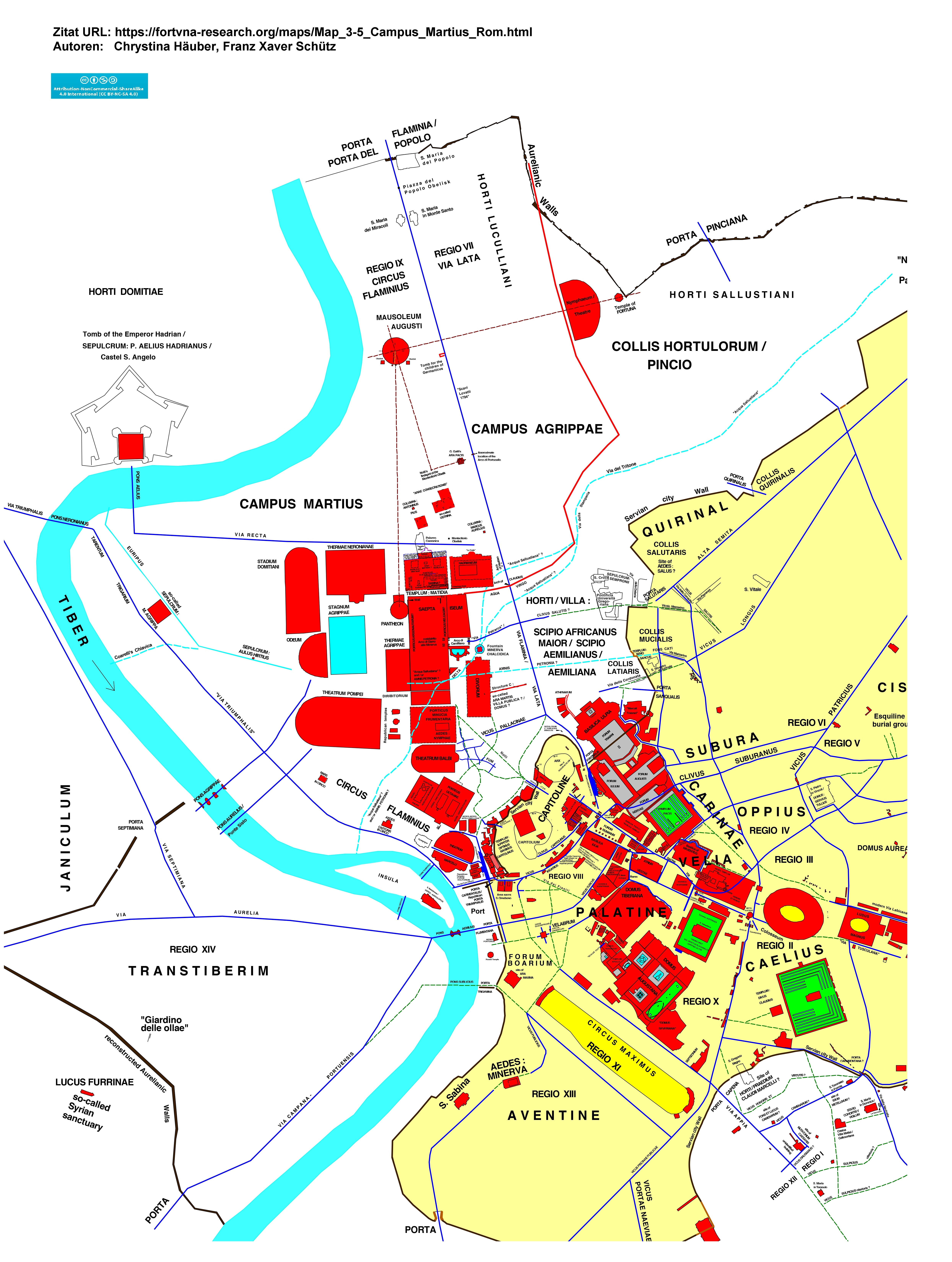
Romkarte. Marsfeld
Legende zur hier veröffentlichten Map 3.5; vergleiche Chrystina Häuber (2017, Seite 62):
"Fig. 3.5
. Map of the Campus Martius in Rome in the Imperial period, with the immediately adjacent quarters of the City within the Servian city Wall. The map is based on the official photogrammetric data of Roma Capitale and is oriented so that North is in the middle of the top border, or, in other words, it is oriented according to `grid north´. The grid is based on the following coordinate system: Roma 1940 Gauss Boaga Est with a transverse Mercator projection. This map shows the output displayed by the "AIS ROMA" without cartographic revision.The ground-plans of ancient buildings that can be securely located are drawn as red areas. The locations and sizes of some ancient buildings are not precisely known; the contour lines of their ground-plans are therefore drawn with broken lines. Ancient roads are drawn with 3 m wide dark blue lines, reconstructed ancient roads as broken dark green lines, gardens as dark green areas, squares as light grey areas, and socles of monuments, standing on squares, as dark grey areas. Water basins are drawn as light blue areas, and water courses are shown either as light blue areas or are marked as light blue lines. The city, bounded by the Servian city Wall, is marked as a yellow area, the documented, and the still extant sections of the Servian city Wall are drawn with light brown lines, the reconstructed course of the Servian city Wall with 3 m wide dark brown lines. The piers of the Arco di Camilliano and of the cosiddetto Arco di Giano alla Minerva are drawn after A. Ten (2015, 57 Fig. 27 and p. 67 Fig. 42).
The photogrammetric data were generously provided by the Sovraintendente ai Beni Culturali of Roma Capitale. C. Häuber, reconstruction. This map was made with the "AIS ROMA" (C. Häuber and F.X. Schütz 2017)."
Download kompletter Band: FORTVNA PAPERS II (77 MB)
Der folgende Text ist (verändert) aus Chrystina Häuber (2017, Seiten 147-153) übernommen:
"By looking at my map Fig. 3.5, it seems plausible to assume the following: the "Via Petrarca"/ Clivus Salutis?, coming up from the Campus Martis, after entering the City by the Porta Salutaris, was divided into two branches, one led to the north-east to the Temple of Salus, the other branch led in a south-easterly direction (following the course of the current Vicolo Mazzarino) and ended at the Via della Consulta/ Vicus Salutis. The latter road, which at times had certainly been called Clivus Salutis, came up from the Vicus Longus, and led likewise to the Temple of Salus. Or in other words: from the south-east (from the Vicus Longus) came a road called Clivus Salutis, and from the south-west, from the Campus Martius, came the "Via Petrarca", leading to the same Temple, which was possibly likewise called Clivus Salutis. In addition to that is seems as if both `branches´ of the road Clivus Salutis (if that is what they were) were interconnected by means of a road, which is currently called Vicolo Mazzarino.
But a problem remains: F. Coarelli ("Sacra Via", in: [LTUR] IV 1999, 226, 227), has explained the choice of the name `via´ for the Sacra Via, by suggesting that this road had already this name when it was located `outside the settlement´; cf. Häuber 2013, 155. If true, the "Via Petrarca", if at all named after the Temple of Salus, should have been called: Via Salutis.
Cf. here Fig. 3.5., labels:"Via Petrarca"/ CLIVUS SALUTIS?; Servian city Wall; PORTA SALUTARIS. Going in your imagination from there left, you reach the: Site of AEDES: SALUS?; ALTA SEMITA. Going from the Temple of Salus to the south-east, you reach the: Via della Consulta/ VICUS SALUTIS [= CLIVUS SALUTIS]; VICUS LONGUS. Going from the Porta Salutaris to the right, you reach the: Vicolo Mazzarino; Via della Consulta/ VICUS SALUTIS [= CLIVUS SALUTIS]; VICUS LONGUS.
Besides, the "Pontificia Università Gregoriana" (cf. Figs. 3.5; 3.7), which was built on the western slope of the Quirinal, covers in great part a gigantic ancient building, the Temple of Serapis of the Augustan Regio VI, which, according to other scholars, should instead be identified as a Temple dedicated to Hercules and Liber Pater, or else, as a sanctuary comprising Temples of all three divinities, cf. Häuber (2014, 74 with n. 231, p. 83 with n. 304, pp. 229-230). See also F. Coarelli (2014, 207-243: "19. Serapis").
Considering the fact that this temple stood on the Collis Salutaris (cf. here Fig. 3.5, labels: QUIRINAL; COLLIS SALUTARIS) it is understandable that L. Richardson, JR. (1992a, 341-342, s.v. Salus, Aedes) had identified this building with the Temple of Salus, although his identification does not account for the Egyptian and Egyptianizing sculptures that have been found there in past centuries (for those, cf. Häuber 2014, 229-230).
The Sepulcrum of the Sempronii at the Via della Dataria, discussed in this section, stood very close to - and I would like to suggest here: possibly even within - the horti Scipionis, to which we will now turn. Of course, this idea has already been suggested before, for example by Monika Verzár-Bass (1998, 416-417 with ns. 99-102, Fig. 14).
The horti Scipionis on the Collis Latiaris
This estate, called villa and horti in our sources, had at first been owned by none less than Publius Cornelius Scipio Africanus maior (236-183 BC, cos. 205 and 194 BC), as F. Coarelli has convincingly suggested (cf. Häuber 1994, 912 with n. 26). According to F. Coarelli and P. Grimal, this estate was bounded in the west by the Via Flaminia/ Via Lata. Coarelli and other scholars assume that this estate had later been the property of Scipio Africanus maior's son-in-law, Tiberius Sempronius Gracchus (cos. 177 and 163 BC, cens. 169 BC), the father of the tribunes Tiberius and Gaius Sempronius Gracchus, and of Sempronia (born ca. 164 BC, who married in 150 or 148 BC her cousin, Scipio Aemilianus), the wife of Scipio Aemilianus (185/4-129 BC, cos. 147 and 134 BC). The literary sources, which refer to the horti Scipionis, mention some of these gentlemen. Since about 150 until 129 BC (the year of his death), Scipio Aemilianus is supposed to have met in those horti Scipionis with his friends, the so-called Scipionic Circle. As Coarelli convincingly suggests (quoted verbatim below), the available literary sources allow the conclusion that these horti Scipionis were located on the Collis Latiaris, one of the four summits of the Quirinal, which, contrary to the other three colles belonging to it, lay outside the pomerium/ the Servian city Wall (to this I will return below).
In n. 26, Häuber 1994, 921, quotes: "F. Coarelli in: Gli Etruschi a Roma. Incontro in onore di M. Pallottino (1981) 183. 186 (Quellen). 187; ders., in: Architecture et société de l'archaïsme grec à la fin de la république romaine, Collection de l'École Française de Rome 66 (1983) 200 ...".
Cf. here Fig. 3.5, labels: Servian city Wall; QUIRINAL; COLLIS QUIRINALIS; PORTA QUIRINALIS; PORTA SALUTARIS; COLLIS SALUTARIS; Site of AEDES: SALUS?; PORTA SANQUALIS; COLLIS MUCIALIS; TEMPLE: SEMO SANCUS; COLLIS LATIARIS; "Via Petrarca"; CLIVUS SALUTIS? SEPULCRUM: SEMPRONII; HORTI/ VILLA: SCIPIO AFRICANUS MAIOR/ SCIPIO AEMILIANUS/ AEMILIANA.
Pierre Grimal (1984, 125) has alerted us of the fact that, `since the end of the Republic, the entire quarter outside the Servian city Wall, immediately to the north of the Capitoline, up to the first slopes of the Quirinal, had been known under the name >Aemiliana<´. As he likewise convincingly suggested (cf. Grimal 1984, 124; cf. pp. 123-125), part of the vast property of the horti Scipionis was later owned by Agrippa, a fact that, in Grimal's opinion, had certainly facilitated his project to build the Aqua Virgo. On p. 106 n. 8, Grimal 1984 wrote that the area of the horti Scipionis belonged to the Campus Martius. I myself follow T.P. Wiseman 1993b, 220, who suggests instead that the boundary of the Campus Martius in the east had "probably" always been the Via Flaminia/ Via Lata. But Wiseman 1993b, 222, writes also: "Scipio Africanus owned horti in the Campus (Cic. nat. deor. 2.11, ad Q. fr. 2.2.1; cf. Gran. Lic. 9.4 F) ..."; cf. F. Coarelli 2014a, 124-125 (to this I will return below, infra, p. 328).
For literary sources, that corroborate Grimal's observation that there had existed a quarter, called Aemiliana, in the area indicated by Grimal (op.cit.); cf. L. Richardson, JR. (1992a, 3; s.v. Aemiliana, and op.cit., p. 11, s.v. Amphitheatrum Statilii Tauri; quoted verbatim infra, p. 328); Rodríguez Almeida ("Aemiliana", in: LTUR I (1993) 19-20, Figs. 4-5); and Andrew B. Gallia and Eric J. Kondratieff ("Aemiliana (2)", in: Haselberger et al. 2002 [= 2008] 41).
L. Richardson, JR. (1992a, 204, s.v. Horti Scipionis) wrote: "Cicero (Phil. 2.109) indicates that this had passed into the possession of Mark Antony by 44 B.C. but was still known as Horti Scipionis" (cf. Häuber 1994, 912 n. 25). See E.A. Dumser ("Horti Scipionis", in: Haselberger et al. 2002 [= 2008] 147 map index 103), who comments on this source as follows: "This may or may not refer to the horti under consideration here (in favor of this identification is Richardson [op.cit.], while Coarelli thinks that the reference is to the Tivoli villa of Scipio Metellus)", quoting F. Coarelli ("Horti Scipionis", in: LTUR III [1996] 83-84).
Cf. Häuber (1994, 912 with ns. 13-31); Häuber (2014, 287 with n. 373, with further references, quoting. F. Coarelli: "Auguraculum (Collis Latiaris)", in: LTUR I [1993], 143; cf. id.: "Argei sacraria; 5. Collis Latiaris sexticeps ...", in: op.cit., p. 124). Cf. F. Coarelli ("Horti Scipionis", in: LTUR III [1996] 83); C. Lega ("Sepulcrum: Sempronii", in: LTUR IV [1999] 297, Figs. 149-150); E.A. Dumser ("Horti Scipionis map index 103"; "Quirinalis, Collis", in: Haselberger et al. 2002 [= 2008] 147; 212). For the (disputed) course of the pomerium, cf. G. Filippi and P. Liverani (2014-2015, 82 with n. 18 and Fig. 8).
Cf. J. Briscoe ("Cornelius [RE 336] Scipio Africanus (the elder), Publius ..."), in: OCD3 (1996) 398; E. Badian ("Sempronius [RE 53] Gracchus (2), Tiberius ..."), in OCD3 (1996) 1384; E. Badian ("Cornelius [RE 335] Scipio Aemilianus Africanus (Numantinus), Publius ..."), in: OCD3 (1996) 397-398; W. Erskine ("Scipionic Circle"), in: OCD3 (1996) 1369.
But not all scholars are of the opinions summarized above concerning the questions, when and by whom the horti Scipionis were founded, and where exactly they were located.
Jon Albers (2013, 196) writes: "Der Komplex des Pompeius [cf. here Figs. 3.5; 3.7, label: THEATRUM POMPEI] gilt als der erste öffentliche Garten Roms innerhalb einer Portikus ... [with n. 22, with references] ... Die grundsätzliche Existenz von Gartenanlagen im Bereich des Marsfeldes ist schon früher, aber in anderen Formen, bezeugt. Bei der Einführung von Gärten in Rom ist wohl den Gebieten des Scipio Aemilianus und des D. Iunius Brutus [Cic. Amic. 1.7; 7.25] eine besondere Bedeutung beizumessen" (my emphasis), with n. 24, quoting: "Grimal 1969, 121-123. Die Annahme, dass diese ersten Gärten auf dem Marsfeld konzipiert wurden, ist zwar laut Favro 1996, 177 Anm. 79 wahrscheinlich, aber nicht eindeutig gesichert" (my emphasis).
Now, after what was said above, the `gardens of Scipio Aemilianus´, are, of course the horti Scipionis discussed here. Diane Favro (1996, 176-177), is therefore wrong in assuming that it were Scipio Aemilianus and D. Iunius Brutus, who first introduced horti to the city of Rome: "Private houses in the city had always had kitchen gardens; sacred plantings dotted the cityscape. Inspired by the splendid paradeisoi or garden paradises of eastern cities, the philhellenes Scipio Aemilianus and D. Junius Brutus had introduced private pleasure parks to Rome in the later part of the second century B.C. [with n. 79]" (my emphasis).
In reality that had already been done two generations earlier by Scipio Africanus maior, who had built those horti that were later the property of his granddaughter's husband, Scipio Aemilianus (but, as we shall see below, not even Scipio Africanus maior had been `first´ in this respect). In her pertaining note 79, Favro (1996, 318) writes: "The gardens of these consuls were probably located in the Campus Martius region; Cic. Amic. 1.7; 7.25, Rep. 1.9" (my emphasis). As we have likewise seen, the area of the horti Scipionis was regarded by Grimal as pertaining to the Campus Martius, whereas for more recent scholars the Campus Martius was bounded in the east by the Via Flaminia/ Via Lata.
If that is true, how then should we define the area, which was located to the east of the Via Flaminia/ Via Lata?, for example that of the horti Scipionis? As is well known, this road divided in the Augustan period two Regiones; cf. Domenico Palombi ("Regiones quattuordecim. Planimetria generale"): in: LTUR IV (1999), Fig. 84 fuori testo; and here Fig. 3.5, labels: VIA FLAMINIA/ VIA LATA; REGIO IX CIRCUS FLAMINIUS; REGIO VII VIA LATA.
I think, it is possible to answer this question. The area to the east of the Via Flaminia/ Via Lata belonged to the slopes of the Quirinal and to those of the Collis Hortulorum, respectively: as the horti Scipionis show, which were located on the Collis Latiaris, one of the summits of the Quirinal. And Vincent Jolivet believes that the area immediately to the east of the Via Flaminia/ Via Lata, which had been identified by Robert E.A. Palmer as that of the Horti Pompeiani superiores, had instead belonged to the Horti Luculliani, which stood on the Collis Hortulorum/ Pincio. Cf. R.E.A. Palmer (1990, 2-13); V. Jolivet ("Horti Luculliani"; "Horti Pompeiani", in: LTUR III (1996) 67-70, esp. p. 67; 78-79; cf. Häuber 2014, 785 with n. 26).
Basing this idea on P. Grimal (1984, 123), according to whom, some "grands jardins" (i.e., horti) were located to the east of the Via Flaminia/ Via Lata since the Republic, I suggest the following. It was therefore on the slopes of those hills, that started rising immediately to the east of the Via Flaminia/ Via Lata, where probably all those private horti were located, which Strabo (5.3.8, C236) mentioned in his enthusiastic praise of the Campus Martius (for that, cf. infra, pp. 180, 328, 371-373). Simply because of those estates, which stood farther away, that is to say, on the hilltops of the Quirinal and of the Collis Hortulorum/ Pincio, only the highest buildings and trees could possibly have been visible to someone standing on the Campus Martius. For a discussion of this topic, see also Appendix 9; The findings concerning the Mausoleum Augusti that were published by H. von Hesberg (2006), infra, p. 483ff.
See here Fig. 3.5, labels: VIA FLAMINIA/ VIA LATA; REGIO IX CIRCUS FLAMINIUS; REGIO VII VIA LATA; CAMPUS MARTIUS; CAMPUS AGRIPPAE; AQUA VIRGO; HORTI LUCULLIANI; HORTI/ VILLA: SCIPIO AFRICANUS MAIOR/ SCIPIO AEMILIANUS/ AEMILIANA; COLLIS LATIARIS; Servian city Wall; PORTA SANQUALIS; COLLIS MUCIALIS; "Via Petrarca"/ CLIVUS SALUTIS?; Pontificia Università Gregoriana; Via della Dataria; SEPULCRUM: SEMPRONII; PORTA SALUTARIS; COLLIS SALUTARIS; Site of AEDES: SALUS?; PORTA QUIRINALIS; COLLIS QUIRINALIS; QUIRINAL; COLLIS HORTULORUM; PINCIO.
For the area discussed here, see also the map in the LTUR V (1999) 356-357 "Fig. 89. Viminalis collis. Sovrapposizione delle evidenze antiche alla topografia moderna. Elaborazione di C. Buzzetti con la collaborazione di E. Gatti (da Il nodo di S. Bernardo (1977), tav. 2)"; as well as F. Coarelli (2014a, 2-3: "Fig. 1. Pianta del Quirinale e del Viminale (da Grande-Scagnetti [1979])", pp. 16-17: "Fig. 3. Pianta del Quirinale e del Viminale nell'antichità (da Pietrangeli 1977, modificata)", pp. 22-23: "Fig. 4. Pianta del Quirinale e del Viminale (da Hülsen 1994)", and passim).
In an earlier article (cf. Häuber 1994, 911), I had asserted: ""Scipio [Africanus maior, 236-184, cos. 205 and 194 BC] war "der erste vornehme Römer, der nach unserer Kenntnis eine (Luxus-)villa besaß" [with n. 10, quoting for that: J. D'Arms 1970, 1]. Sie befand sich bei der 194 v. Chr. gegründeten Kolonie Liternum in Campanien, wohin er sich im Jahre 184 v. Chr. ins "Exil" zurückzog"". Concluding my relevant reasoning on p. 912 as follows: provided this is true, ""... Scipio Africanus maior [hat] unserer Überlieferung zufolge nicht nur als "erster" eine villa maritima in Campanien [with n. 30, providing a reference] (und vielleicht sogar im ager Laurentinus [with n. 31, providing a reference]) besessen, sondern auch als erster eine villa suburbana in unmittelbarer Nähe zur Stadt [Rom]"".
This was obviously not true. But we shall see in the next section that also other scholars are of this opinion.
In Häuber (2014, 287), I wrote instead: "According to Israël Shatzman [with n. 375], M. Claudius Marcellus [cos. 222 BC, cf. op.cit., p. 286], the conqueror of Syracuse, was the first senator known to us as an owner of horti, and since no other location has been suggested, I tentatively locate this estate in the area under scrutiny here (map 3, labels: site of HORTI/ PRAEDIUM: CLAUDII MARCELLI? site of AEDES: HONOS et VIRTUS? of SEPULCRUM: CLAUDII MARCELLI ? of ARA: FORTUNA REDUX?), quoting in n. 375: "SHATZMAN 1975, pp. 12, 246 n. 11; cf. FRASS 2006, pp. 15, 245-246 with n. 1274-1280, 1282". See also here Fig. 3.5, labels: CIRCUS MAXIMUS; Servian city Wall; PORTA CAPENA; VIA APPIA; Site of HORTI/ PRAEDIUM CLAUDII MARCELLI?; VICUS HONORIS ET VIRTUTIS?
Let's now turn to the consular auspices, preceding the elections at the Saepta, that were taken on the Collis Latiaris at the horti of Scipio Africanus maior (in 163 BC, as described by Cicero Nat. D. 2.3.10-11)
The consular auspices, preceding the elections at the Saepta, that were taken on the Collis Latiaris at the horti of Scipio Africanus maior (in 163 BC, as described by Cicero Nat. D. 2.3.10-11)
See Filippo Coarelli ("Horti Scipionis", in: LTUR III [1996] 83): "Ricordati sola da Cic.[ero] nat. deor. 2.4.11: Ti. Gracchus (cos. 163: RE IIA Sempronius 53): vitio sibi tabernaculum captum fuisse hortos Scipionis, quod cum pomerium postea intrasset habendi senatus causa, in redeundo, cum idem pomerium transiret, auspicari esset oblitus (cfr. Gran. Lic. 9 Flemisch). Da questo passo si ricava che gli horti erano fuori del pomerio, ma a breve distanza da questo, che in essi veniva posto l'auguraculum destinato all'auspicatio che il console doveva celebrare prima di aprire i comitia elettorali (in particolare quelli per l'elezione dei consoli, cui si riferisce l'episodio); infine, la loro esistenza nel 163 a.C., che permette di attribuirne la creazione [i. e., of the horti Scipionis] a P. Cornelius Scipio Africanus (RE IV Cornelius 336) e non all'Aemilianus (RE IV Cornelius 335) che sarebbe stato allora troppo giovane (era nato nel 185).
La posizione probabile degli horti ne risulta così determinata con grande probabilità in un'area prossima ai Saepta (che dovevano essere visibili dall'auguraculum), dove avevano luogo i comizi consolari, e in un punto elevato rispetto a questi ultimi: quindi, o sul Quirinale o sul Gianicolo. La probabile vicinanza al pomerio e il mancato ricordo dell'attraversamento del Tevere, che pure avrebbe richiesto la particolare procedura degli auspicia peremnia (Fest. 296 L), inducono ad optare per il primo. Siamo infatti informati da Varrone (ling. 5.52) dell'esistenza sul collis Latiaris, la sommità più meridionale del Quirinale di un Auguraculum (v.[edi]) la cui funzione è quindi collegata ai comizi del campus Martius. Ciò permette di collocare con tutta probabilità gli h.[orti] S.[cipionis] sulle pendici del collis Latiaris, subito fuori delle Mura Serviane, e cioè nell'area corrispondente a Piazza Magnanapoli e ai Mercati Traianei [cf. here Figs. 3.5; 3.7, labels: Servian city Wall; PORTA SANQUALIS; COLLIS LATIARIS; Largo Magnanapoli; "Mercati Traianei"].
L'indicazione di Cic. Phil. 2.109 si riferisce non al suburbio di Roma, ma alla villa di Scipio Metellus a Tivoli".
If Coarelli is right with his last remark, and provided that my own idea is true as well that the Sepulcrum of the Sempronii, discussed above, stood within the horti Scipionis - assuming at the same time that the Sempronii, who built this tomb, owned the area in question - this would allow two conclusions. 1.) that Coarelli's location of the horti Scipionis on the Collis Latiaris is correct, and 2.) that the horti Scipionis, built by Scipio Africanus maior, were still owned by members of his family in the first century BC.
Only after this section was written so far, did it occur to me that F. Coarelli (2014a, 122-129), in his section "Iuppiter Latiaris (Auguraculum)", has published further research on this subject. Especially interesting are previously not considered inscriptions: they prove that the Cornelii Scipiones actually had property in this area.
On pp. 122-127, Coarelli (2014a), discusses again in detail all the literary sources concerning the consular auspices, taken by Tiberius Sempronius Gracchus (cos. 177 and 163 BC, cens. 169 BC; for him, cf. supra, pp. 148-149), and the context, in which they should be seen. Tiberius Gracchus had taken the consular auspices in 163 BC, preceding the elections at the Saepta, and what interests us here is the fact that he had taken them on the Collis Latiaris, at the horti of Scipio Africanus maior. On pp. 127-129, Coarelli (2014a) continues:
""Qui interessa particolarmente il luogo dove il console [i.e., Tiberius Sempronius Gracchus] aveva posto il suo tabernaculum, che certamente corrispondeva al templum augurale, collegato funzionalmente ai comitia elettorali. Questo luogo è indicato da Cicerone [cf. op.cit., pp. 124-125] e confermato da Granio Liciniano [cf. op.cit., p. 125]: si trattava degli horti Scipionis. Ma dove si trovavano questi horti?
Intanto, certamente fuori del pomerio, come risulta dalle esplicite indicazioni di Cicerone, e dal fatto stesso che si trattasse di horti. Questa del resto sembra la regola per gli auguracula pubblici [with n. 171]. È importante sottolineare che questi horti esistevano già nel 163 a.C., cioè che si tratta dei più antichi attestati a Roma [as we have seen above, supra, p. 151, this is not true]. Questa data dimostra inoltre che essi erano stati realizzati già da Scipione Africano, e non da Scipione Emiliano, come in genere si pensa [with n. 172]. Sappiamo che essi alla fine della repubblica erano nelle mani di Antonio [i.e., Mark Antony], e forse precedentemente erano appartenuti a Pompeo [with n. 173]. Grimal li colloca sul collis Hortulorum, a nord della villa di Lucullo, ma questa posizione è del tutto improbabile: trattandosi della più antica villa suburbana di cui si abbia notizia, è preferibile pensare che essa si trovasse in un luogo più vicino ai limiti della città. In tal caso, unica zona proponibile sono le pendici del Quirinale verso il Campo Marzio. Tale ipotesi è confermata da alcune iscrizioni, che consentono di localizzare alcune proprietà dei Cornelii Scipiones sul colle [with n. 174]. Tra queste, fondamentale è una piccola base di marmo, scoperta nel 1977 [corr.: 1877] tra Palazzo Rospigliosi e via Mazzarino, cioè nella parte sud-occidentale del Quirinale [with n. 175], purtroppo perduta. Il testo, secondo Hülsen, è certamente di età repubblicana, è il seguente: "P. Cornelius P.f./Scipio". Non può trattarsi che di Scipione Africano o di Scipione Emiliano, quindi la base doveva sorregere il ritratto di uno dei due. Il fatto che essa sia realizzata in marmo, in un periodo così antico, conferma l'importanza del personaggio rappresentato [with n. 176]. Si potrebbe pensare, data l'esiguità della base, a un busto-ritratto esposto, ad esempio, in un larario. Il luogo di ritrovamento conferma comunque la localizzazione degli horti in una zona corrispondente al collis Latiaris.
Ora, sappiamo che su questo si trovava l'Auguraculum del Quirinale, menzionato da Varrone [cf. op.cit., pp. 122-123]. Mi sembra così giustificato la conclusione che si trattasse dello stesso in cui Ti. Gracco aveva posto il suo tabernaculum in occasione dei comizi consolari del 163 a.C.: evidentemente, la relativa zona del collis Latiaris era stata nel frattempo inclusa entro gli horti. Possiamo così comprendere la funzione di questo Auguraculum: esso doveva essere il luogo da cui si prendevano gli auspicia in rapporto con i comizi elettorali. Il motivo della scelta di esso non è difficile da comprendere: si tratta infatti dell'unica sommità che domina la zona del Campo Marzio dove si trovavano i Saepta: la sua posizione è in un certo modo equivalente a quella dell Arx rispetto al Comitium. Nessun luogo meglio del collis Latiaris avrebbe potuto prestarsi a questa funzione.
Così il cerchio si chiude: l'Auguraculum del Quirinale costituisce la replica di quello dell'Arx, allo stesso modo in cui i Saepta costituiscono una replica del Comitium: si tratta di due complessi funzionali simili ed equivalenti"" (my emphasis).
See also the plan, published by F. Coarelli (2014a, 128): "Fig. 33. Pianta con gli auguracula dell'Arx e del collis Latiaris, con indicazione degli assi della spectio" (to this plan, I will return below, cf. infra, pp. 314-315).
In his n. 171, Coarelli (2014a, 127) quotes: "Ad esempio, quello di Gubbio (SISANI 2001, pp. 139-184)"; in his n. 172: "Ad es.[empio], GRIMAL 1969, pp. 121-123"; in his n. 173: "COARELLI 1977[b], p. 816, nota 19"; in his n. 174: "[Laura] CHIOFFI 1999; LTUR V [1999], Addenda et corrigenda, p. 264 (L. Chioffi)"; in his n. 175: "CIL I2, p. 202; VI 31608"; in his n. 176 on p. 128, Coarelli 2014a, writes: "Scipione Africano sembra essere il primo a Rom ad utilizzare il marmo per un edificio pubblico, l'arco da lui innalzato sul Campidoglio nel 190: Liv. 37.3.7". For this arch, erected by Scipio Africanus maior on the Capitoline, cf. Häuber (2005, 22 with n. 78).
Coarelli (op.cit.) suggests that the small (lost) marble pedestal, carrying an inscription (CIL I2, p. 202; VI 31608), must have carried a portrait of Scipio Africanus maior or of Scipio Aemilianus. He believes that the relevant portrait once stood in a lararium, and therefore (convincingly) regards this pedestal as a proof for his hypothesis that the area in question belonged to the villa/ horti of Scipio Africanus maior on the Collis Latiaris. Since this pedestal was found between Palazzo Pallavicini Rospigliosi and Via Mazzarino, a findspot, which is close to the Sepulcrum of the Sempronii on Via della Dataria, my suggestion (for that, cf. supra, p. 148), according to which also this tomb may once have stood within the same horti, sounds likewise more convincing now.
For the toponyms mentioned above, cf. Figs. 3.5; 3.7, labels: QUIRINAL; COLLIS LATIARIS; HORTI/ VILLA: SCIPIO AFRICANUS MAIOR/ SCIPIO AEMILIANUS/ AEMILIANA; Via della Dataria; SEPULCRUM SEMPRONII; Fontana di Monte Cavallo/ `Quirinal obelisk´; Via XXIV Maggio; Palazzo Pallavicini Rospigliosi (Galleria); FONS CATI; Via Mazzarino; CAPITOLINE; ARX; 40 m; Site of AUGURACULUM?; FORUM ROMANUM; Site of COMITIUM."
Datenschutzerklärung | Impressum