


Giambattista (G.B.) Nolli's Rome map and the original location of the Montecitorio Obelisk
The problem here, as is well known, are the facts that neither the Montecitorio Obelisk, nor the Ara Pacis can still be studied in situ. We must therefore rely on those who have documented their original settings. Whereas the original position and size of the ground-plan of the Ara Pacis and its enclosure are well documented, Giambattista (G.B.) Nolli, whose large Rome map (1748), which was drawn to the scale ca. 1: 2910, and is normally regarded as being extremely accurate, had actually indicated in the first phase of his map the findspot of the Montecitorio Obelisk at a wrong location (see here Fig. 3.1a. For the second, in this detail corrected phase of his map, cf. Fig. 3.1b).
On the other hand it is likewise well known that Nolli, by very precisely drawing the ground-plan of the Palazzo Fiano-Almagià, especially its south-east corner, which is today located at the north-west corner of the junction of the roads Via in Lucina and Via del Giardino Theodoli (cf. Figs. 3.2; 3.6, label: former Palazzo Fiano-Almagià), had thus unconsciously documented the precise location and orientation (!) of the Ara Pacis and its enclosure - facts which were only understood when those were excavated.
|
Fig. 3.1a Fig. 3.1b |
|
|
Fig. 3.3. |
Fig. 3.4 |
Figs. 3.1a; 3.1b; 3.3; 3.4. Details from G.B. Nolli's large Rome map (1748). Fig. 3.1a shows a detail of the first phase of the map, with wrong representation of the lying shaft of the Montecitorio Obelisk in situ. After F. Ehrle 1932. Fig. 3.1b shows Nolli's corrected second version of this detail of his Rome map (1748, "secondo stato". See for both phases infra, n. 53). After M. Bevilacqua 1998, 15. Fig. 3.3 shows the detail with the incised corner of the former Palazzo Fiano-Almagià. After F. Ehrle 1932 (the red arrows point at the walls that were built on top of the Ara Pacis Augustae). Fig. 3.4 shows the area of S. Giovanni in Laterano with the Lateran obelisk (index no. 10. Cf. here Fig. 5.1 and ns. 64, 214, Appendix 5, Appendix 10) and the lying shaft of the Horti Sallustiani obelisk (index no. 14. Cf. here Fig. 4 and ns. 9, 63, Appendix 10; and the Contribution by Vincent Jolivet in this volume). After F. Ehrle 1932.

Fig. 3.2. The north-west corner of the junction of the roads Via in Lucina and Via del Giardino Theodoli, looking from south towards the incised corner of the former Palazzo Fiano-Almagià. Photo: F.X. Schütz (29-V-2016).
Interestingly, the position, where in 1752 should be erected the Montecitorio Obelisk, is also on Nolli's map occupied by a monument. He gave it the index number 338: "Piazza di Monte Citorio, e Piedestallo della Colonna Antonina", which has a square ground-plan, and there is also the index number "340 Colonna Antonina giacente", although the map does not show the lying column of Antoninus Pius. Cf. for both, Ehrle 1932, 11. Erika Simon (erroneously) wrote: "Auf dem Marsfeld auf der heutigen Piazza di Montecitorio 1703 gefunden, zusammen mit der Säule, einem Monolith von 14,75 m Höhe [i.e., 50 Roman feet] aus rotem Granit. Diese zerbrach bei den Hebungsarbeiten und durch Brandeinwirkung. Ihre Reste wurden zur Ausbesserung des augusteischen [!] Gnomon-Obelisken verwendet, den man an der Stelle der Säule errichtete ..." (cf. ead.: "Sockel der Säule des Antoninus Pius", in: Helbig4 I [1963] 378, no. 480).
Whereas Nolli was right, because the monument was at his time temporarily kept there, Simon was wrong, because the column had not been excavated at this site, but instead in its vicinity. The whole procedure has been described by Sonia Maffei ("Columna Antonini Pii", in: LTUR I [1993] 298-300, Fig. 175, a coin representing the monument). On p. 299, she writes: "Per tutto il medioevo e fino all'inizio del XVIII sec.[olo] il fusto era rimasto visibile, per una altezza di quasi sei metri, su quello che allora era chiamato Mons Citatorius o Acceptorius. La colonna, nota con il nome di Columna Citatoria era ritenuta il sostegno usato in antico per affigere citazioni giudiziarie e bandi di magistrati in relazione all'attività dei comizi. Nel 1703 per ordine di Papa Clemente XI fu dato inizio agli scavi del monumento che terminarono portando alla luce l'intero fusto della colonna e la base scolpita con i rilievi. Il luogo esatto di rinvenimento della base fu identificato da Ch. Hülsen ad O [vest] dell'attuale Parlamento [i.e., Palazzo di Montecitorio] (ex Curia Innocenziana) a 39 metri da Via della Missione. Nel 1705 il monumento fu trasportato nella Piazza Montecitorio, dove rimase, dopo i primi interventi di restauro sui rilievi del piedestallo (1706-1708), fino al 1759, quando un incendio scoppiato dietro la Curia Innocenziana, tra le strutture di protezione del monolite, dannegiò gravemente il fusto della colonna ...".
The Columns of Marcus Aurelius and Antoninus Pius belonged to the "Arae Consecrationis", that had been erected in this area (for those, cf. Eugenio La Rocca 1984, 101-114; Alberto Danti: "Arae Consecrationis", in: LTUR I [1993] 75-76, "Fig. 41. Arae consecrationis. Pianta generale di L. Messa [da La Rocca ... [1984], fig. 11. For the Column of Marcus Aurelius, cf. Sonia Maffei: "Columna Marci Aurelii Antonini", in: LTUR I [1993] 302-305, Fig. 178; Häuber 2014, 727 with ns. 61-65).
See also Eugenio la Rocca's map of the Campus Martius, labelled: COLUMNA ANTONINI PII (cf. id. 2012, Fig. 8, index no. 40; and index no. 39: Arae consecrationis; id. 2014, 133, Fig. 11, index nos. 39; 40; id. 2015a, 60, Fig. 40, index nos. 39; 40); Katharina Friedl (2012); and Markus Wolf (2015). - Or, as Heinz-Jürgen Beste and Henner von Hesberg (2015, 290), have aptly called this impressive ensemble of monuments and buildings, the "paesaggio delle apoteosi sul Campo Marzo". Since most of these huge buildings were erected on top of the artificial mound currently called Monte Citorio (for that, cf. infra, pp. 232-233, 275-276), it would be interesting to reconstruct this ensemble in its topographic setting in order to better understand its impact on its surroundings.
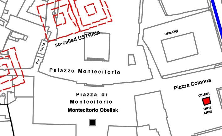
For the just-mentioned toponyms, cf. here Figs. 3.5; 3.7, labels: Palazzo Montecitorio; Piazza di Montecitorio; Montecitorio Obelisk; COLUMNA: MARCUS AURELIUS; COLUMNA: ANTONINUS PIUS; "ARAE CONSECRATIONIS"; so-called Ustrina; Via degli Uffici del Vicario; Via della Missione.
It is of interest to ask in this context, when exactly the artificial mound called Monte Citorio was created. Katharina Friedl (2012, 374-375) suggests the following: "Im Zuge der von 1907 bis 1910 laufenden Bauarbeiten für einen neuen Gebäudeflügel des Palazzo Montecitorio stieß man in der durch die Via dell'Impresa und die Via della Missione gebildeten Ecke, unter dem heutigen Sitzungssaal, auf Reste eines antiken Monuments [i.e., the so-called ustrinum or ara consecrationis of Marcus Aurelius], das in Folge größtenteils freigelegt werden konnte (Abb. 7) [with n. 109]. In der Typologie und Dimension von etwa 30 m x 30 m wies es große Ähnlichkeiten zum sog. Ustrinum des Antoninus Pius auf. Topographisch gab es allerdings einen entscheidenden Unterschied: Das Bauwerk unter dem Parlament wurde mitten auf einer Erhöhung, dem Montecitorio, gebaut und war vom Weiten [!] sichtbar. Das sog. Ustrinum des Antoninus Pius lag dagegen in der Ebene westlich unterhalb des Hügels und hatte somit einen weniger exponierten Platz (Abb. 4 [= detail of R. Lanciani, FUR, fol. 15]) [with n. 110]".
In her n. 109, K. Friedl (2012, 374) provides references, in her n. 110 on p. 375, she writes: "Beim Montecitorio handelt es sich um eine künstliche Aufschüttung unbekannter Zeit ([providing references]). m.[eines] E.[rachtens] muss der Hügel zum Zeitpunkt der Erbauung des sog. Ustrinum des Marc Aurel bereits existiert haben. Danti 1984, 144 zufolge wurden die heute noch in situ liegenden Fundamentblöcke 3,90 m unterhalb der Via della Missione entdeckt. Das wäre in etwa die Höhe, in der das Bodenniveau seit der Antike angestiegen ist (vgl. dazu den Sockel der Markussäule ... [with reference]). Somit könnte die Topographie für die frühere Entstehung des sog. Ustrinum des Marc Aurel sprechen, da sich ansonsten die Frage stellt, wieso nicht bereits für das sog. Ustrinum des Antoninus Pius der repräsentativere Platz gewählt wurde. Doch ist eine Aufschüttung speziell für das sog. Ustrinum des Marc Aurel nicht auszuschließen".
As we shall see below (cf. infra, pp. 233, 275-276), the Monte Citorio is much larger than indicated on Lanciani's FUR (fol. 15), and, in my opinion, much older than suggested by K. Friedl (op.cit.).
Obiger Text von Chrystina Häuber stammt aus FORTVNA PAPERS 2, ab Seite 50 hier ohne Fußnoten. Zu FORTVNA PAPERS 2 mit download des Originalbandes.The visibility of the shadows cast by the Montecitorio Obelisk (cf. here Fig. 1.1).
This question has been discussed in great detail by almost all contributors to Frischer's article.
In this context two problems have so far not attracted the interest they deserve: first of all we should remember that the area in question was perhaps usually very crowded, at least on sunny days when Augustus' solar spectacle would in theory have been visible, instead of being so completely `empty´ as in (almost) all reconstructions of `Augustus' solar park´ that have been published so far (cf. for example the recent reconstructions mentioned supra, n. 134). But there is an exception. Haselberger publishes an etching as his Fig. 3 which he attributes to James Stuart [cf. here Fig. 10.1]. The caption of this fig. reads: "James Stuart, reconstructive view of the Augustan-era Campus Martius, c.[irca] 1749. The gnomon-obelisk of the Horologium [by other scholars interpreted as Meridian device] stands in the center of a wide, paved square, with the Mausoleum of Augustus on the left side and the Pantheon, in its supposed Augustan form, on the right". Personally I am convinced that, in addition to this, the area in question was not so flat, as assumed in all recent reconstructions, and hope to pursue this question in the future, together with Franz Xaver Schütz. See the system of archaic streams, like the "Acqua Sallustiana", and/ or the hollow ways in the area in question (cf. supra, pp. 205-206, and Figs. 3.5; 3.7).
Concerning Augustus' meridian, Frischer and Fillwalk agree with some of Albèri Auber's hypotheses:
"The obelisk was used to support a sphere, which served as a gnomon only for a meridian, not for an entire horologium inscribed on a large pavement, for which no evidence has been found. The purpose of the obelisk-meridian device was scientific. Albèri Auber argues that it helped ensure the correct tracking of leap years through the observatio umbrarum (Pliny, NH 2.35). There is only one phase for the obelisk-meridian: The Augustan. Buchner's Flavian phase is a phantom based on interpreting two different quota levels as reflective of two phases: the lower Augustan, the higher Flavian. We follow Albèri Auber in interpreting the higher level of the meridian as evidence that the meridian was designed to rest atop an embankment, for two reasons: first, to provide easier access to the person charged with the responsibility for the observatio umbrarum, second, to protect it from periodic flooding of the Tiber". As mentioned before, Frischer and Fillwalk were also able to locate the excavated section of the meridian precisely.
Obiger Text von Chrystina Häuber stammt aus FORTVNA PAPERS 2, ab Seite 352 hier ohne Fußnoten. Zu FORTVNA PAPERS 2 mit download des Originalbandes.Datenschutzerklärung | Impressum


