
Veränderter Textauszug ohne Fußnoten aus:
Chrystina HÄUBER, Franz Xaver SCHÜTZ (2010): The Sanctuary Isis et Serapis in Regio III in Rome: Preliminary Reconstruction and Visualization of the ancient Landscape using 3/4D-GIS-Technology.Für den kompletten Originalartikel mit Fußnoten, vgl. download pdf hier
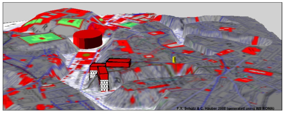
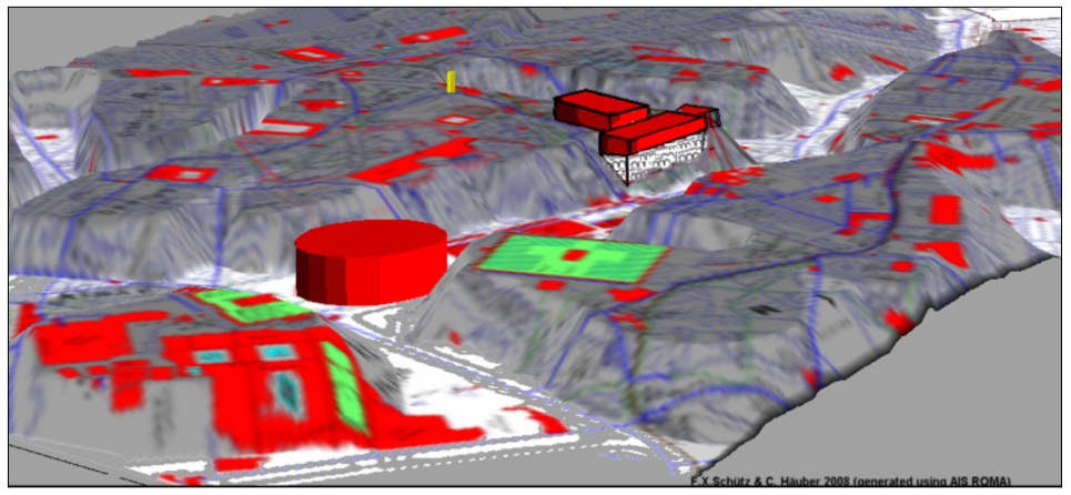
Für den Effekt, dass beim "Hochfalten" einer 2D Karte (= hier Fig. 1) in 3D (hier Fig. 2 und Fig. 3) die Grundrisse der antiken Gebäude (= die roten Flächen auf der 2D-Karte) wie "Dali-Uhren" aussehen; vgl. Chrystina HÄUBER (2014, Seite 27 mit Anmerkung 187).
Chrystina Häuber, Franz Xaver Schütz
The Sanctuary Isis et Serapis in Regio III in Rome: Preliminary Reconstruction and
Visualization of the ancient Landscape using 3/4D-GIS-Technology
Introduction
The findings presented here were obtained by applying new computer-based methods to already known material (old maps and excavation drawings as well as unpublished archival material). We used those data for the reconstruction of ancient buildings in plan and of the ancient landscape. Over the years our ideas concerning this area have matured, what follows is the current state of our knowledge.
The `Porticus with Piscina´ / the sanctuary Isis et Serapis in the Augustan Regio III
Rodolfo Lanciani labelled this structure, found while building the road Via Buonarroti in 1885 (later L. da Vinci, today: A. Poliziano; fig. 1) on his map Forma Urbis Romae (FUR, fol. 30) as "Tempio Egizio (Regio III) ISIS ET SERAPIS". At first we did not follow Lanciani and referred to this building as `Porticus with Piscina´. The reasons for our caution were three: within this building no Aegyptiaca were ever documented, the ground plan of this structure (measuring 122 x 93 m in our new reconstruction, fig. 1) does not show the characteristic eclecticism of Roman sanctuaries of the Egyptian cults, and there are no temples for Isis and Serapis. Because of the water channels and some water storage facilities found there we reconstruct the open area within this building as a garden. Unfortunately the `Porticus with Piscina´ was only vaguely dated by its excavators.
de Vos identifies the `Porticus with Piscina´ and several adjacent buildings with the sanctuary of the Egyptian cults, but she bases her hypothesis on some wrong assumptions. In this paper we will demonstrate that this building was in fact part of this sanctuary (fig. 1, label "ISIS ET SERAPIS, "Porticus with Piscina", FORUM: PETRONIUS MAXIMUS"). This is possible because of the new evidence published by Ingo Herklotz, who studied the finds made by Leonardo Agostini in the 1650s in this area. An analysis shows that some of the finds recorded by Agostini were still visible and described in the garden of the Capuchin monks by Friedrich Matz and Friedrich von Duhn8. As we shall see, this allows the identification of the `Porticus with Piscina´ as part of the sanctuary Isis et Serapis.
Nymphaea east of the `Porticus with Piscina´
East of the `Porticus with Piscina´ stood a circular, probably Republican structure and an Imperial one with rectangular groundplan. Because of their hydraulic installations both were surely correctly identified by their excavators as Nymphaea (fig. 1, labels: Round Nymphaeum; Nymphaeum). de Vos identifies the round building with the temple of Serapis, because she erroneously believes that Pirro Ligorio saw the `Cerbero del Bufalo´ of Villa Albani, a marble statue of a cerberos, there. Pirro Ligorio saw the `Cerbero del Bufalo´ in the ancient building called "Terme di Filippo" (fig. 1, label: "Terme di Filippo").
The forgotten Hadrianic building in Vigna Reinach
Lanciani described in 1880 an ancient brick building, measuring at least 130 x 40 m in plan, containing brick stamps of the year AD 123, in Vigna Reinach, which was located between Via R. Bonghi and modern Via Labicana (fig. 1, label: Vigna XII Apostoli / Reinach). This building, which was completely overlooked in recent studies, was perhaps a substructure or else a monumental staircase. Those scholars who support the reconstruction of the sanctuary Isis et Serapis by de Vos follow her suggestion that the `Porticus with Piscina´ was accessible over terraced ramps.
The Nymphaeum at Piazza Iside and the substructure on Via Pasquale Villari
East of the building in Vigna Reinach stood the Hadrianic Nymphaeum of Piazza Iside (fig. 1, label: Nymphaeum Piazza Iside). Adjacent to the east stood the partly extant substructure on Via P. Villari, Pirro Ligorio's "Terme di Filippo". It is built in opus reticulatum and has several building phases (late Republican, Augustan, Flavian and Hadrianic). We drew its ground plan after Nolli's map. That the complete structure as drawn by Nolli was ancient is proven inter alia by Giuseppe Magi's etching of the new church of SS. Pietro e Marcellino (1753). Some antiquaries believed that this substructure extended so far north, as to incorporate the ancient building which had contained the former church of S. Matteo in Merulana (fig. 1), only to be divided from the `Terme di Filippo´, when the modern road of Via Merulana was built (fig. 1). Based on a report datable to the 18th century, prior to Nolli's map, from which we learn that a great section of this building had recently been destroyed, we drew a pink area indicating the loss; the building stood at the time in Vigna Cicolini (fig. 1, label: Vigna Cicolini).
The Lucus Querquetulanae Virae, the Porta Querquetulana and the Servian city Wall
The Nymphaeum at Piazza Iside stood at the slope of the Oppian, above the valley of modern Via Labicana, which follows an unknown archaic road. The adjacent substructure on Via P. Villari, the ground floor of which is buried under modern street level, stood at a much lower level than the Nymphaeum; one phase of it was built under Domitian. Recently another substructure built under Domitian was excavated south of the church of SS. Pietro e Marcellino. Gianfranco de Rossi identifies this substructure tentatively as Horrea (fig. 1, labels: SS. Pietro e Marcellino; HORREA ?: the yellow dot marks the excavation area).
In this part of the Oppian remains of the Servian Wall were described in the 19th century, `leading through the Vigna Capaccini down towards SS. Pietro e Marcellino´ (fig. 1). We have, therefore, re-located the Porta Querquetulana at the ancient road underneath modern Via Labicana near the old church of SS. Pietro e Marcellino (fig. 1, the label "SS. Pietro e Marcellino" refers to both churches, the old one is indicated by a red area). As part of this hypothesis we suggest that the Nymphaeum at Piazza Iside replaced the natural spring within the sacred grove of the Querquetulanae Virae. The Lucus of those Nymphs `touched´ the Porta Querquetulana at its inner side (fig. 1, label: LUCUS QUERQUETULANAE VIRAE).
The area of the `Porticus with Piscina´ bordered on the Horti Maecenatiani. De Vos interprets a "cippo funerario aniconico", found at the junction of Via P. Verri with Via P. Villari as proof that Horace was right in saying that "la zona era occupata da una necropoli per schiavi". We conclude, therefore, that Maecenas, who had just cleared this graveyard, must have extended his Horti from the Porta Esquilina in the north to the Porta Querquetulana in the south (fig. 1). We know that Maecenas loved to sit with his poets in the shade of an oak tree, called "quercus" in this text, listening to "nymphas cadentes" (`falling waters´). We have, therefore, suggested that Maecenas sat under one of the oak trees of the former Lucus of the Querquetulanae Virae which he had incorporated into his Horti.
The Servian city Wall and the temple of `Minerva Medica´ / Fortuna Virgo
When ashlar masonry walls and a Republican votive deposit (datable between the 4th-2nd centuries BC), comprising dedications to Minerva were found in 1887 south of the former Via Curva/C. Botta, they were immediately attributed to the temple of Minerva Medica. Its location on plan is based on a drawing by the excavators (fig. 1).
Carlo Ludovico Visconti wrote that "the temple of Minerva Medica stood in front of a building shortly before inhabited by Capuchin monks", and "within the Servian Wall"; the latter statement is overlooked by most scholars. Data provided by Wolfgang Helbig, by Matz and von Duhn and Lanciani's FUR (fol. 30) allow the conclusions that this former Capuchin monastery occupied the Casino of the former Villa D'Aste and the adjacent estate and that the Casino stood on Via Curva (fig. 1, label: Capuchin monastery).
Considering also the sections of the Servian Wall found in situ in this area (fig. 1, labels: Esq. a; Esq. b / Via Mecenate 35), we conclude that the former Via Curva followed the course of the Servian Wall.
Since the shrine on Via Carlo Botta and its votives were found inside the Servian Wall, this was not the temple of Minerva Medica recorded by the Constantinian regionary catalogues for Regio V, because that Regio should be identified with the area outside the Servian city Wall (fig. 1, labels: REGIO III; R. V). We have, therefore, set the name of this Republican shrine in inverted commas (fig. 1, label: "MINERVA MEDICA").
Others have rejected the identification of this Republican shrine with the temple of Minerva Medica either also because of topographical problems, or because of doubts concerning its cult patron. The worshippers of this shrine attributed the cult patron(s) with power over health, marriage and the sphere of female reproduction, including the protection of infants.
One type of terracotta heads of very young, veiled women from the shrine on Via Carlo Botta shows the traditional headdress of brides, the sex crines. Considering the location of the shrine on Via Carlo Botta near a gate in the Servian Wall, and that some of its votives and one marble statue from this area represent brides, we identify this shrine with the temple of Fortuna Virgo. We also identify the round Nymphaeum or the one at Piazza Iside (fig. 1) with the "fons muscosus" described by Plutarch near the temple of Fortuna Virgo. Other middle- and late Republican Etrusco-Latial shrines, where rites of passage were performed, are also located near city gates.

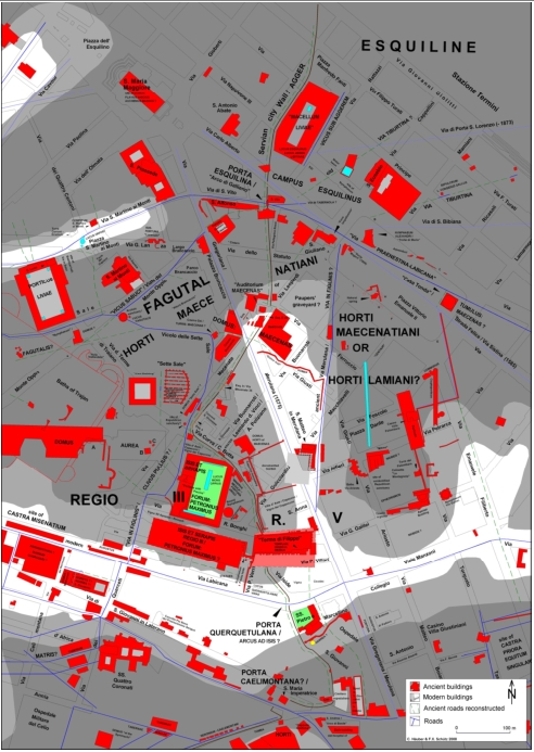
Fig. 1: The area of the sanctuary Isis et Serapis in Regio III in Rome and the adjacent Horti Maecenatiani. The current street plan was drawn after the photogrammetric data of the Comune di Rome. Integrated into this background is a shaded relief map, based on G.B. NollIi's Rome map (1748) and on modern studies. Ancient buildings, including many churches, are indicated with red areas, some are copied after NollIi's map, the light grey areas within them are courtyards, reconstructed courtyards are indicated with lighter grey areas, reconstructed ancient buildings with pink areas, the reconstructed extension of the plateau of the Oppian near Via A. Poliziano is indicated with a grey area bordered by a dotted line, the green areas indicate gardens, light blue areas water basins, ancient roads are indicated with dark blue lines (3 m wide), post-antique roads copied after Nolli's map with lighter blue lines (3 m wide), reconstructed ancient roads with green dotted lines, extant sections of the Servian city Wall with light brown lines (4 m wide), the reconstructed course of the Servian city Wall with dark brown lines (4 m wide). The map was created with the AIS ROMA 2008, Chrystina Häuber and Franz Xaver Schütz (preliminary reconstruction).

Fig. 2: The area of the sanctuary Isis et Serapis in Regio III in Rome and the adjacent Horti Maecenatiani, seen from east. `Three dimensional´ computer visualization on the basis of the map fig. 1. It was created with the AIS ROMA 2008, Franz Xaver Schütz and Chrystina Häuber (preliminary reconstruction).

Fig. 3: The area of the sanctuary Isis et Serapis in Regio III in Rome and the adjacent HortiMaecenatiani, seen from southwest. `Threedimensional´ computer visualization on the basis of the map fig. 1. It was created with the AIS ROMA 2008, Franz Xaver Schütz and Chrystina Häuber (preliminary reconstruction).
Für den kompletten Originalartikel mit Fußnoten, vgl. download pdf hier
Für neuere Forschungen und Publikationen zum Thema siehe:
HÄUBER, C. 2014, The Eastern Part of the Mons Oppius in Rome: the Sanctuary of Isis et Serapis in Regio III, the Temples of Minerva Medica, Fortuna Virgo and Dea Syria, and the Horti of Maecenas. With Contributions by Edoardo Gautier di Confiengo and Daniela Velestina, 22. Suppl. BullCom, Roma: <<L'ERMA>> di Bretschneider 2014.
HÄUBER, C. 2017, Augustus and the Campus Martius in Rome: the Emperor's rôle as Pharaoh of Egypt and Julius Caesar's Calendar Reform; the Montecitorio Obelisk, the Meridian Line, the Ara Pacis, and the Mausoleum Augusti in Honour of Eugenio La Rocca on the Occasion of His 70th Birthday, FORTVNA PAPERS II, herausgegeben von F.X. SCHÜTZ und C. HAUBER (München: Hochschule München, 2017). Online at: https://fortvna-research.org/FORTVNA/FP2.html
Links zu neuen und weiterführenden Karten:
Alle Stadtmauern Roms - Karte des archaischen Rom mit den späteren Stadtmauern (Servianische und Aurelianische Stadtmauern)Datenschutzerklärung | Impressum